Wancheng, Nanyang
This article needs additional citations for verification. (July 2007) |
Wancheng
宛城区 | |
|---|---|
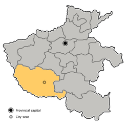
 Wancheng in Nanyang. Note the map does not include the sub-prefecture-level city of Dengzhou. | |
 Nanyang in Henan | |
| Coordinates: 33°00′14″N 112°32′23″E / 33.0038°N 112.5396°E / 33.0038; 112.5396 | |
| Country | People's Republic of China |
| Province | Henan |
| Prefecture-level city | Nanyang |
| Area [1] | |
| • Total | 880 km2 (340 sq mi) |
| Population (2019)[2] | |
| • Total | 938,200 |
| • Density | 1,100/km2 (2,800/sq mi) |
| Time zone | UTC+8 (China Standard) |
| Postal code | 473000 |
| Website | http://www.wancheng.gov.cn/ |
Wancheng District (simplified Chinese: 宛城区; traditional Chinese: 宛城區; pinyin: Wǎnchéng Qū) is one of two districts of the city of Nanyang, in the southwest of Henan province, People's Republic of China.
Administrative divisions
As 2012, this district is divided to 6 subdistricts, 4 towns and 6 townships.[3]
- Subdistricts
|
|
- Towns
|
|
- Townships
|
|
Education
Higher education
- Nanyang Institute of Technology[4](南陽理工學院)
- Henan Polytechnic Institute[5](河南工業職業技術學院)
See also
- Expressways of Henan
- China National Highways
- Expressways of China
- Henan
- Wolong District
- Nanyang, Henan
References
Wikimedia Commons has media related to Wancheng District.
Look up Wancheng in Wiktionary, the free dictionary.
- ^ 最新人口信息 www.hongheiku.com (in Chinese). hongheiku. Retrieved 2021-01-12.
- ^ 最新人口信息 www.hongheiku.com (in Chinese). hongheiku. Retrieved 2021-01-12.
- ^ 安阳市-行政区划网 www.xzqh.org (in Chinese). XZQH. Retrieved 2012-05-24.
- ^ "English-南阳理工学院". www.nyist.edu.cn. Archived from the original on 2018-02-27.
- ^ http://www.hnpi.cn/ (Chinese)