Wikipedia:WikiProject Maps/Conventions/Location maps
This page provides conventions for the creation of location maps.

Location maps are an extremely light and chartjunk-free style. They focus on the subject, most of the time a country, and its official borders and subdivisions borders. This style purposely uses soft and print-friendly colors to ease the superimposition of labels or dots, as well as non-CIA based colors.
Usage: These maps are used especially by Template:Location map which uses geolocalisations to add a location mark (like ![]() ) and/or a label onto the map in the browser. They are also used as background for locator maps to enlight the place and area of major subdivisions in a country, of a species range, etc. They may also be used as background for Exchanges maps, or as an administrative layer up on Topographic maps by keeping the borders only.
) and/or a label onto the map in the browser. They are also used as background for locator maps to enlight the place and area of major subdivisions in a country, of a species range, etc. They may also be used as background for Exchanges maps, or as an administrative layer up on Topographic maps by keeping the borders only.
Where: these maps can be found on commons, in the category Location_maps_(2008_standard).
Convention

| Subject | Colorimetry (RGB/hex) |
|---|---|
| Toponymes (names) | #000000
R:0 G:0 B:0 |
| Border. Labels (country/state/province's name) | #646464
R:100 G:100 B:100 |
| Subject's area (country, province) | #FEFEE9
R:254 G:254 B:233 |
| Other areas part of the same political unity | #F6E1B9
R:246 G:225 B:185 |
| Outside area | #E0E0E0
R:224 G:224 B:224 |
| Coasts of lakes, rivers, seas, and hydronyms (Temporary coastlines, color and ratio: opacity:0.6;dasharray:4, 4;stroke-width:1;) |
#0978AB
R:9 G:120 B:171 |
| Ocean, sea, lake (Temporary body, color and ratio: opacity:0.6;stroke-dasharray:4, 4;stroke-width:1;) |
#C6ECFF
R:198 G:236 B:255 |
|
Naming (upload):
and so on, but please focus your energy on countries first. | |
|
Further needs: | |
| SVG template: if you need some labels, please use Image:Maps_template-en.svg which provide further label conventions. | |
Purpose
This project focuses on making location maps for articles in the English Wikipedia, although map making is a cross-language effort coordinated across Wikipedias of various languages. A convention and set style is followed when constructing these maps.
Location maps are widely used with the {{Superimpose}} and {{Location map}} templates, to display the coordinates of a city, building, battle, etc. Accordingly, they are used in the infoboxes of many articles.
History and current work
- History
This convention takes its style from the Public Domain CIA World Factbook's maps previously uploaded on Wikipedia, but has evolved toward a more web-friendly, screen friendly, and wiki-specific style. User:STyx (fr) made the first basic proposal. Dozens of discussions on several wikipedias have eventually lead to this current style, with User:Sting (fr), NNW (de) & co helping a lot to spread the decided conventions by producing a large number of such maps. In 2008 the French and German cartographic labs —the two most productive organized teams— synchronized their styles.
- Interesting innovations
Traditionally, most atlases display borders, especially international ones, as bold lines, while neighboring countries' territories may be confusingly whitened and erased from the map. After discussions, the current consensus is to instead use doted lines for borders such —– – —– – —— or – – – (ex: Portugal_administrative_map-fr.svg), with the rationale that borders are not walls, people have always crossed them, and as an NGO and international community of volunteers, we do not support the nationalistic view that space stops at a country's border. Also, as a second consensus, neighboring countries or territories should NOT be “wiped off the map”. This is considered rude and doesn't make sense geographically.
- Leaders
Currently, the German team has initiated a large project (Europe 96% done, etc.), and work continent after continent and country after country, to provide a complete set of SVG location maps, respecting these conventions. NNW, Chumwa, Sting, TUBS are the main contributors, several German and non-German users also contribute actively. These users work using GIS software and GIS databases such Gadm.org. Recently (2012), there has been a push on commons for derived locator maps (example: File:New_York_in_United_States.svg). Further help is welcome!
Examples
Location maps
-
 English SVG Template to ease such map creation.
 -
 German SVG Template to ease such map creation.
 -
 1st: Portugal_location_map.svg
 -
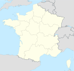 2th: France_location_map.svg
 -
 Another one, displaying a region (yellow), and another region of the same country (orange), and other countries (grey).


- Location maps in use
 Madrid Madrid (Spain) Map with up-to-date example of this style. > Madrid |
- Derivated usages
-
 nd: Portugal administrative map-fr.svg , derivation from Location map, expansion, annotations, dashed border. No color change since all Portugal is the subject, and Spain is not the same entity.
 -
 rd: other example of a labelled Location map


Maperitive style files
- https://wiki.openstreetmap.org/wiki/User:Nzeemin/Maperitive/WikiRegion
- https://wiki.openstreetmap.org/wiki/User:Nzeemin/Maperitive/WikiRegion2
See also
Map conventions and Map Project | |||
|---|---|---|---|
 | Conventions set |
| |
| Drafts | |||
| Others |
| ||