Wallace (lunar crater)
 Apollo 17 Mapping Camera image | |
| Coordinates | 20°18′N 8°42′W / 20.3°N 8.7°W / 20.3; -8.7 |
|---|---|
| Diameter | 26 km |
| Depth | 160 m |
| Colongitude | 9° at sunrise |
| Eponym | Alfred R. Wallace |


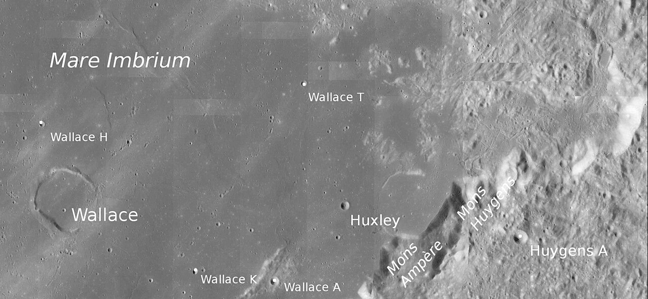
Wallace is the remains of a lunar impact crater that has been flooded by lava. It was named after British natural historian Alfred Russel Wallace.[1] It lies in the southeastern part of Mare Imbrium, to the northeast of the crater Eratosthenes. The crater rim forms a somewhat polygonal outline, and is broken in the southeast. The floor is flat and devoid of significant features, but it is overlain by ray material from Copernicus to the southwest. The rim ascends to an altitude of 0.4 km above the lunar mare.
Satellite craters
By convention these features are identified on Lunar maps by placing the letter on the side of the crater midpoint that is closest to Wallace.
| Wallace | Latitude | Longitude | Diameter |
|---|---|---|---|
| A | 19.2° N | 5.6° W | 4 km |
| C | 17.6° N | 6.4° W | 5 km |
| D | 17.9° N | 5.7° W | 4 km |
| H | 21.3° N | 9.1° W | 2 km |
| K | 19.3° N | 6.8° W | 3 km |
| T | 21.9° N | 5.1° W | 2 km |
The following craters have been renamed by the IAU.
- Wallace B — See Huxley (lunar crater).
View

References
- ^ "Wallace (lunar crater)". Gazetteer of Planetary Nomenclature. USGS Astrogeology Research Program.
- Andersson, L. E.; Whitaker, E. A. (1982). NASA Catalogue of Lunar Nomenclature. NASA RP-1097.
- Bussey, B.; Spudis, P. (2004). The Clementine Atlas of the Moon. New York: Cambridge University Press. ISBN 978-0-521-81528-4.
- Cocks, Elijah E.; Cocks, Josiah C. (1995). Who's Who on the Moon: A Biographical Dictionary of Lunar Nomenclature. Tudor Publishers. ISBN 978-0-936389-27-1.
- McDowell, Jonathan (July 15, 2007). "Lunar Nomenclature". Jonathan's Space Report. Retrieved 2007-10-24.
- Menzel, D. H.; Minnaert, M.; Levin, B.; Dollfus, A.; Bell, B. (1971). "Report on Lunar Nomenclature by the Working Group of Commission 17 of the IAU". Space Science Reviews. 12 (2): 136–186. Bibcode:1971SSRv...12..136M. doi:10.1007/BF00171763. S2CID 122125855.
- Moore, Patrick (2001). On the Moon. Sterling Publishing Co. ISBN 978-0-304-35469-6.
- Price, Fred W. (1988). The Moon Observer's Handbook. Cambridge University Press. ISBN 978-0-521-33500-3.
- Rükl, Antonín (1990). Atlas of the Moon. Kalmbach Books. ISBN 978-0-913135-17-4.
- Webb, Rev. T. W. (1962). Celestial Objects for Common Telescopes (6th revised ed.). Dover. ISBN 978-0-486-20917-3.
- Whitaker, Ewen A. (1999). Mapping and Naming the Moon. Cambridge University Press. ISBN 978-0-521-62248-6.
- Wlasuk, Peter T. (2000). Observing the Moon. Springer. ISBN 978-1-85233-193-1.
External links
Wikimedia Commons has media related to Wallace (lunar crater).
- Wallace at The Moon Wiki
- Wood, Chuck (March 27, 2004). "What is a Dome? (and Surroundings)". Lunar Photo of the Day. Archived from the original on 2007-11-13.
- Wood, Chuck (May 6, 2009). "A Museum Piece". Lunar Photo of the Day.