User:FudgeFury/Sandbox 2
| This is a Wikipedia user page. This is not an encyclopedia article or the talk page for an encyclopedia article. |
——————————————— FudgeFury ———————————————
|
|
| Sandboxes of Farjad0322 |
|
|
Pakistan has 25 protected areas known as national parks. As of 2009, 19 of these are under supervision of respective provincial governments and remaining are in private care.[1] Only some of these are under the conservation scope of International Union for Conservation of Nature (IUCN). Protection and conservation of the environment of Pakistan was included in the concurrent constitution of 1973. As a result, Environment Protection Ordinance was enacted in 1983, which was mainly regulated by the Environment and Urban Affairs Division. Later, a new system of 'Modern Protected Areas' legislation began at the provincial level which assigned the protected areas with designations such as national parks, wildlife sanctuaries and game reserves. Further recommendations of the national parks of the Indomalaya ecozone were highlighted in the IUCN review of 1986.[2] Nevertheless, the development of national parks was mainly carried out by National Conservation Strategy of 1992. Due to increased awareness about their importance in conservation of biodiversity, 10 national parks have been established during the time period from 1993 to 2005.[1]
According to the 'Modern Protected Areas' legislation, a national park is a protected area set aside by the government for the protection and conservation of its outstanding scenery and wildlife in a natural state. It is accessible to public for research, education and recreation. In order to promote public use, construction of roads and rest houses is permitted. Use of firearms, polluting water, cleaning of land for cultivation, destruction of wildlife is banned in these areas.[3] The oldest national park is Lal Suhanra in Bahawalpur District, established in 1972.[4] It is also the only biosphere reserve of Pakistan. Lal Suhanra is the only national park established before the independence of the nation in August 1947. The main purpose of this area was to protect the wildlife of Cholistan Desert.[3] The most recent addition is the Kala Chitta in Attock District, established in 2009.[4] Central Karakoram in Gilgit Baltistan is currently the largest national park in the country, spanning over a total approximate area of 1,390,100 ha (3,435,012 acres). The smallest national park is the Ayub, covering a total approximate area of 931 ha (2,301 acres).
| National Parks of Pakistan | |
 1 2 3 valley 4 5 6 7 8 9 10 11 12 13 14 15 16 17 18 19 20 21 22 23 24 25 26 27 28 Click on a 'mark' to open the article of the respective national park |
|
National parks
| National park | Picture | Established | Area | Location | Description |
|---|---|---|---|---|---|
| Ayub | —
|
931 ha (2,301 acres)[5] | Rawalpindi District Punjab 33°34′00″N 73°30′00″E / 33.566700°N 73.499998°E / 33.566700; 73.499998 (Ayub National Park) |
Originally known as 'Topi Park', it was renamed 'Ayub National Park' in honor of the late Ayub Khan in 1970. It is currently the smallest national park in Pakistan. The park is located along the Grand Trunk Road and also features a golf course and an animal theme park, Jungle World.[6] | |
| Ayubia | 1984[3] | 3,312 ha (8,184 acres)[7] | Abbottabad District Khyber Pakhtunkhwa 33°51′55″N 73°08′20″E / 33.865231°N 73.138768°E / 33.865231; 73.138768 (Ayubia National Park) |
Named after the constituent village of Ayubia, the park covers many galyat of the Himalayas. Highest point is the Miranjani. The park features temperate alpine and broadleaf coniferous forestry and is a refuge for Kalij and Koklass pheasants.[8] | |
| Central Karakoram | 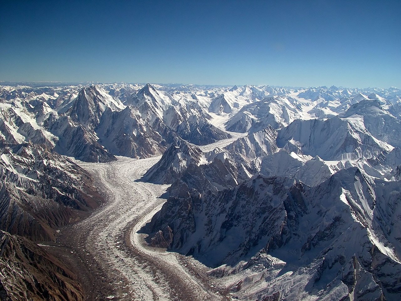
|
1993[3] | 1,390,100 ha (3,435,012 acres)[1] | Gilgit and Skardu Districts Gilgit Baltistan 36°53′52″N 75°05′37″E / 36.897708°N 75.093545°E / 36.897708; 75.093545 (Central Karakoram National Park) |
It is the largest national park in Pakistan and includes many glaciers like Baltoro and mountains like K2.[9] Central Karakoram National Park is also one of the most visited mountaineering areas on the globe. The park features temperate alpine and broadleaf coniferous forestry and is a refuge for markhor and snow leopard.[10] |
| Chinji | 1987[3] | 6,095 ha (15,061 acres)[1] | Chakwal District Punjab 33°00′37″N 72°29′31″E / 33.010242°N 72.491940°E / 33.010242; 72.491940 (Chinji National Park) |
The park is located close to the Salt Range and Soan River. It features xeric biome of Indus Valley Desert ecoregion[11] and is characterized to have many plant species of importance like Cynodon dactylon.[12] The park is also a refuge for Urial.[13] | |
| Chitral Gol | 
|
1984[3] | 7,750 ha (19,151 acres)[1] | Chitral District Khyber Pakhtunkhwa 35°55′59″N 71°40′14″E / 35.933082°N 71.670693°E / 35.933082; 71.670693 (Chitral Gol National Park) |
Originally created as a game reserve in 1880 by the Mehtar, it was declared a wildlife sanctuary in 1971 and a national park in 1984. Chitral Gol, located in Himalayas, is a narrow valley through which Kunar River flows. It features temperate alpine coniferous forestry and is a refuge for markhor and snow leopard.[14] |
| Deosai | 
|
1993[3] | 358,400 ha (885,626 acres)[1] | Skardu District Gilgit Baltistan 34°58′21″N 75°23′47″E / 34.972626°N 75.396423°E / 34.972626; 75.396423 (Deosai National Park) |
Deosai meadows and pastures are present around the Shoesar Lake of Skardu District. A jeep track has been developed for the sake of ecotourism.[15] The park features montane grassland biome of Karakoram-West Tibetan Plateau alpine steppe ecoregion and is a refuge for Himalayan brown bear.[16] |
| Deva Vatala | 
|
2009[4] | 2,993 ha (7,396 acres)[17] | Bhimber District Azad Kashmir 32°53′33″N 74°18′11″E / 32.892583°N 74.303172°E / 32.892583; 74.303172 (Deva Vatala National Park) |
The park is a refuge for hog deer and striped hyena.[17] |
| Dhrun | 1988[18] | 167,700 ha (414,396 acres)[18] | Awaran and Lasbela Districts Balochistan 25°41′25″N 66°12′15″E / 25.690405°N 66.204289°E / 25.690405; 66.204289 (Dhrun National Park) |
||
| Ghamot | 2004[19] | 27,271 ha (67,388 acres)[17] | Neelum District Azad Kashmir 35°00′25″N 74°12′01″E / 35.006943°N 74.200287°E / 35.006943; 74.200287 (Ghamot National Park) |
||
| Gurez | 
|
2009[20] | 52,815 ha (130,509 acres)[17] | Neelum District Azad Kashmir 34°43′53″N 74°47′12″E / 34.731456°N 74.786682°E / 34.731456; 74.786682 (Gurez National Park) |
The park is a refuge for musk deer. |
| Hazarganji-Chiltan | 1980[3] | 15,555 ha (38,437 acres)[1] | Quetta District Balochistan 30°17′09″N 67°12′08″E / 30.285695°N 67.202298°E / 30.285695; 67.202298 (Hazarganji-Chiltan National Park) |
||
| Hingol | 
|
1988[3] | 165,004 ha (407,734 acres)[1] | Awaran, Gwadar and Lasbela Districts Balochistan 25°31′34″N 65°05′10″E / 25.526246°N 65.085996°E / 25.526246; 65.085996 (Hingol National Park) |
|
| K2 | 
|
—
|
233,468 ha (576,912 acres)[21] | Gilgit District Gilgit Baltistan 35°47′17″N 76°10′58″E / 35.788171°N 76.182888°E / 35.788171; 76.182888 (K2 National Park) |
|
| Kala Chitta | 2009[4] | —
|
Attock District Punjab 33°38′34″N 72°24′03″E / 33.642685°N 72.400824°E / 33.642685; 72.400824 (Kala Chitta National Park) |
||
| Khunjerab | 1975[3] | 226,913 ha (560,714 acres)[1] | Gilgit District Gilgit Baltistan 36°30′03″N 75°38′37″E / 36.500805°N 75.643616°E / 36.500805; 75.643616 (Khunjerab National Park) |
||
| Kirthar | 
|
1974[3] | 308,733 ha (762,896 acres)[1] | Dadu District Sindh 25°39′29″N 67°32′56″E / 25.658107°N 67.548975°E / 25.658107; 67.548975 (Kirthar National Park) |
|
| Lal Suhanra | 1972[4] | 87,426 ha (216,034 acres)[1] | Bahawalpur District Punjab 29°23′51″N 72°01′33″E / 29.397409°N 72.025811°E / 29.397409; 72.025811 (Lal Suhanra National Park) |
||
| Lulusar-Dudipatsar | 
|
2003[3] | 30,375 ha (75,058 acres)[3] | Mansehra District Khyber Pakhtunkhwa 35°05′27″N 73°55′47″E / 35.090698°N 73.929749°E / 35.090698; 73.929749 (Lulusar-Dudipatsar National Park) |
|
| Machiara | 1996[3] | 13,532 ha (33,438 acres)[17] | Muzaffarabad District Azad Kashmir 34°30′24″N 73°33′55″E / 34.506557°N 73.565140°E / 34.506557; 73.565140 (Machiara National Park) |
||
| Margalla Hills | 1980[3] | 17,386 ha (42,962 acres)[1] | Rawalpindi District Punjab 33°45′16″N 72°57′23″E / 33.754317°N 72.956429°E / 33.754317; 72.956429 (Margalla Hills National Park) |
||
| Pir Lasura | 2005[3] | 5,625 ha (13,900 acres)[1] | Kotli District Azad Kashmir 33°38′21″N 73°50′48″E / 33.639204°N 73.846664°E / 33.639204; 73.846664 (Pir Lasura National Park) |
||
| Saiful Muluk | 
|
2003[3] | 4,867 ha (12,027 acres)[3] | Mansehra District Khyber Pakhtunkhwa 34°52′51″N 73°41′54″E / 34.880862°N 73.698349°E / 34.880862; 73.698349 (Saiful Muluk National Park) |
|
| Shandur-Hundrup | 
|
1993[3] | 164,000 ha (405,253 acres)[1] | Ghizer District Gilgit Baltistan 36°00′23″N 72°37′01″E / 36.006340°N 72.616882°E / 36.006340; 72.616882 (Shandur-Hundrup National Park) |
|
| Sheikh Buddin | 1993[3] | 15,540 ha (38,400 acres)[1] | Dera Ismail Khan District Khyber Pakhtunkhwa 32°22′56″N 70°56′59″E / 32.382281°N 70.949707°E / 32.382281; 70.949707 (Sheikh Buddin National Park) |
||
| Toli Pir | .jpg/1280px-Toli_Pir_landscape_(6).jpg)
|
2005[3] | 5,045 ha (12,466 acres)[1] | Poonch District Azad Kashmir 34°07′15″N 73°37′59″E / 34.12090°N 73.633118°E / 34.12090; 73.633118 (Toli Pir National Park) |
Pictures
-
Baltoro glacier is found in Central Karakoram National Park
-
Mountains at Chitral Gol National Park
-
Plain of Deosai National Park
-
Mud volcano in Hingol National Park
-
Hills of Toli Pir National Park

.jpg)
References
- ^ a b c d e f g h i j k l m n o p "Review of 'Protected Areas System' in Pakistan: Present status and problems concerning future development (Page 8, 9, 15)" (PDF). dergiler.ankara.edu.tr. Ankara University. 2010. Retrieved September 8, 2010.
- ^ "Pakistan Protected Areas: Meeting Proceedings" (PDF). iucn.pk. IUCN, Pakistan. 1994. Retrieved September 29, 2010.
- ^ a b c d e f g h i j k l m n o p q r s t u "Country Report on Plant Genetic Resources for Food and Agriculture – Pakistan" (PDF). parc.gov.pk. Pakistan Agricultural Research Council. Retrieved September 8, 2010.
- ^ a b c d e "Canadian Journal of Pure and Applied Sciences, an international journal: Current issue (Number: 4, Volume: 2, June 2010) Online ISSN 1920-3853" (PDF). cjpas.net. SENRA Academic Publishers, Burnaby, British Columbia. 2010. Retrieved September 8, 2010.
- ^ "Ayub National Park". wdpa.org. World Database on protected Areas. Retrieved September 8, 2010.
- ^ "About us". jungleworld.com.pk. Jungle World, Pakistan. Retrieved September 30, 2010.
- ^ "Improving Sub-Watershed Management and Environmental Awareness in the Ayubia National Park". wwf.panda.org. WWF -Pakistan. Retrieved September 15, 2010.
- ^ "Ayubia National Park". nathiagali.com. Nathiagali. Retrieved September 15, 2010.
- ^ "Central Karakoram National Park" (PDF). cknp.org.pk. Forest Department, Directorate of Parks and Wildlife. Retrieved September 30, 2010.
- ^ "Land Cover Mapping of the Central Karakoram National Park" (PDF). wwfpak.org. WWF, Pakistan. 2009. Retrieved September 30, 2010.
- ^ "Baluchistan xeric woodlands (PA1307)". worldwildlife.org. World Wildlife Fund (WWF). Retrieved September 22, 2010.
- ^ "Status of flora at Chinji Forest Preserves" (PDF). docsdrive.com. Pakistan Journal of Biological Sciences 3 (5). Page: 876-880. 2000. Retrieved September 22, 2010.
- ^ "Ovis orientalis". iucnredlist.org. The IUCN Red List of Threatened Species. 2010. Retrieved September 22, 2010.
- ^ Green, Michael (1990). IUCN directory of South Asian protected areas. The World Conservation Monitoring Unit, IUCN. p. 95. ISBN 2-8317-0030-2. Retrieved September 30, 2010.
- ^ Niaz, Mohammad (August 23, 2009). "Globetrotting: Deosai calling". dawn.com. DAWN News. Retrieved September 30, 2010.
{{cite web}}: CS1 maint: date and year (link) - ^ Nawaz, Ali (2007). "Status of the brown bear in Pakistan" (PDF). bearproject.info. Department of Ecology and Natural resource Management, Norwegian University of Life Sciences. Retrieved September 30, 2010.
- ^ a b c d e "Protected areas of AJK". forest.ajk.gov.pk. Government of Azad and Jammu Kashmir. 2009. Retrieved September 7, 2010.
- ^ a b "Dhrun National Park". wdpa.org. World Database on protected Areas. Retrieved September 8, 2010.
- ^ "(Fourth national report) Biodiversity of Pakistan: Status trends and threats" (PDF). cbd.int. Convention on Biological Diversity, International. Retrieved September 8, 2010.
- ^ "Musk Deer National Park, Guraiz (MDNPG) conflict: Who is responsible?". kashmirnewswatch.com. Kashmir News Watch. Retrieved September 8, 2010.
- ^ "K2 National Park". wdpa.org. World Database on protected Areas. Retrieved September 8, 2010.
Pakistan articles | |||||||||||||||||||
|---|---|---|---|---|---|---|---|---|---|---|---|---|---|---|---|---|---|---|---|
| |||||||||||||||||||
| |||||||||||||||||||
| |||||||||||||||||||
| |||||||||||||||||||
| |||||||||||||||||||
List of national parks of Asia | |
|---|---|
| Sovereign states |
|
| States with limited recognition |
|
| Dependencies and other territories |
|
ur:پاکستان کے نیشنل پارک