User:Farwestern
Welcome to Farwestern's user page. Farwestern shares the ongoing photography of Gregg M. Erickson. Here's some background: Gregg's an Industrial Technology graduate of Cal Poly, 2006 and is interested in anything technology, science and or cycling related. Farwestern is also his gmail.com address should you wish to correspond a little bit. Below you'll find a mini portfolio of Gregg's favorite works. Equipment: Nikon D50, Nikon D80, Nikkor 24mm 2.8, Nikkor 50mm 1.4 primes, Nikkor 18-55mm, 55-200mm, Tokina 11-16mm 2.8
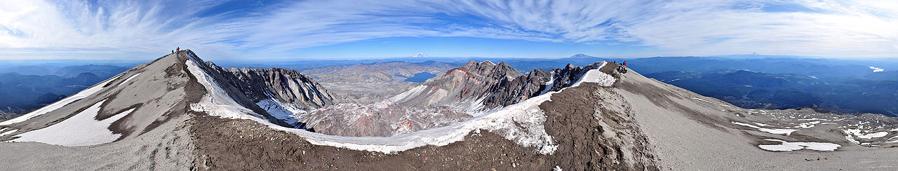
360° panorama from the summit of Mount St. Helens as seen on an early-October afternoon. In the foreground is the ice-covered crater rim. Visible in the lower center is the lava dome. Steam rises from several dome vents. Above the dome, in the upper center, lies Mount Rainier and Spirit Lake. Mount Adams appears to the right of Rainier on the horizon as well as Mount Hood and Mount Jefferson on the far right. Also on the far right are glimpses of the Swift Reservoir, Yale Lake, Lake Merwin and the Lewis River. Climbers stand on the crater rim and are visible along the Monitor Ridge climbing route.

360° panorama near the summit of Mount Ellinor in the Olympic Mountains of Washington State. Mount Washington appears prominently on the right-hand side as well as views of the Hood Canal, Lake Cushman and the Puget Sound.

120° panorama at Tenaya Lake on an early-November morning. Polly Dome is prominent center-left along with Medlicott Dome, center, and Tenaya Peak, right.

360° in the center of the New Idria ghost town.

360° panorama at Montaña de Oro State Park. Appearing on the far-left is Valencia Peak along with the setting sun. The center-right features view of Morro Rock and the stacks of the Morro Bay power plant. The near-full moon can be seen rising in the east

180° Panorama on Playa Santispac of Bahía Concepción, Baja California Sur. Several islands are visible in the bay: (left to right) Isla San Ramon, Isla Blanca, and Isla Coyote. On the right is Playa Concepcion with its associated developments visible.

360° panorama near the summit of Goat Peak in the William O. Douglas Wilderness of the northern Cascades in Washington State. Photographed on a September Afternoon, this photo includes sweeping views of the Methow River Valley and the greater Cascade Range including glaciated Silver Star Mountain. High ice clouds create sun dogs on either side of the September Sun. The Goat Peak Lookout is prominent on the righthand side.


360° panorama from the southwest slope of Mount Zion (Olympics) near the summit, Olympic National Forest.

360° panorama in the Red Canyon, Dixie National Forest, along Scenic Byway 12. Late March.

360° panorama of Mount Amery and the Alexandra River in the Icefields Parkway of Jasper and Banff national parks. Low clouds drift along as the morning sun rises over Mount Wilson.

Panorama looking West-Northwest to Northeast from Marmot Pass in the Buckhorn Wilderness. Buckhorn Mountain and Iron Mountain can be seen in the far right side.

180° panorama from the Wilson Creek Beach, Del Norte Coast Redwoods State Park on an early-September afternoon. On the right, HWY 101 crosses Wilson Creek via bridge. Offshore appear Wilson and False-Klamath Rocks

360° Panorama from Fort Worden State Park, Point Wilson on a sunny July evening at sunset. Batteries Kinzie and Vicars nearby.

270° Panorama of Echo Bay of Sucia Island, San Juan Islands, Washington. Photographed on the Summer Solstice at sunset during a small rain shower.

360° Panorama of the San Juan Islands from Eagle Cliff on Cypress Island.

Panorama showing typical views from Turn Point, Stuart Island, San Juan Islands.

Looking Eastward: 180° panorama at the crest of Marmot Pass in the Buckhorn Wilderness of the Olympic National Forest in Washington State. Iron Mountain appears on the left-hand side with the Puget Sound and Hood Canal visible in the middle.

360° panorama of Cal Poly and San Luis Obispo, CA taken from the top of Poly Canyon; Cerro San Luis (Madonna Mountain) and Bishop Peak in the middle with Cal Poly below.

360° panorama from the summit of Cerro San Luis Obispo. On the left appears Bishop Peak. In the left-center lies the Cal Poly campus. Laguna Lake appears on the right. Photographed on an early November morning.

90° panorama of the Astoria-Megler Bridge and twilight-shrouded Astoria, Oregon. Looking southward from Point Ellice on the Washington side of the Columbia River. On the left, the Astoria Column is visible lit with holiday lights. Just right of the column is Saddle Mountain. In the center, between the piers of Astoria-Megler, lies the Young Bay Bridge, discernible by its overhead lights and the blur of traffic from U.S. Route 26. The sky displays hues of pink and purple in this early-December photo

360° panorama in the courtyard of the Salk Institute for Biological Studies, La Jolla, California.

360° panorama in the courtyard of Stadium High School in Tacoma, Washington

360° panorama of downtown Tacoma as viewed from the Murray Morgan Bridge.

360° panorama of Tacoma Community College's south side.

360° panorama of Titlow Beach Park. This photograph features the Titlow Beach, ruins of an old ferry terminal, and the Tacoma Narrows Bridges.

360° panorama of the Temple of Justice and the Legislative Building of the Washington State Capitol on an August afternoon.

360° panorama of the Wright Park Arboretum in downtown Tacoma, Washington as seen on a summer afternoon.

360° panorama on the campus of Saint Martin's University, Lacey, Washington on a sunny August afternoon.

360° panorama inside the Maryhill Stonehenge replica. Plaques commemorating WWI soldiers can be seen as well as glimpses of the Columbia River

270° panorama overlooking La Jolla Shores as seen from the Martin Johnson House, Scripps Institute of Oceanography, during a late August sunset.

360° panorama of Leavenworth, Washington and the Wenatchee River from a western foothill overlook at 3000 feet.


120° panorama of the Grand Coulee Dam

360° panorama from the site of the San Gorgonio Pass Wind Farm

Half sphere (360° x 180°) Mercator Projection panorama from inside an incomplete nuclear cooling tower, part of the unfinished Satsop Nuclear Power Plant, now the Satsop Development Park, Washington State.

180° panorama from Ruby Beach, Olympic National Park, late in the afternoon of a Sunny September afternoon.

360° panorama overlooking Lulworth Cove, Dorset, England, as seen on an October afternoon.


360° Panorama of Corfe Castle, Dorset, England, as seen on an overcast October afternoon

180° panorama of the Edinburgh skyline at dusk in early October from Calton Hill, Dugald Stewart Monument

270° panorama inside the ruins of the Montgomery Castle, Montgomery, Wales. This panorama shows the castle walls and grassy interior courtyards as well as views of the Welsh countryside as seen on a rainy October afternoon.

360° of the Calton Hill park as seen from the National Monument, Edinburgh. Nelson's Monument is also visible in between columns in the center. To the right side are views of Firth of Forth. To the left rises Arthur's Seat and Holyrood Park.

360° Panorama of the interior of St. Giles' Cathedral, Edinburgh


270° Panorama of a river-carved canyon in the Sierra de San Francisco mountain range of Baja California Sur. The canyon valley and river falls towards the village Santa Teresita. The far right leads to the mountain village San Francisco de la Sierra; the site of numerous prehistoric rock art paintings.

100° panorama on the waterfront of Santa Rosalía, Baja California Sur.

North side exterior of Misión San Francisco Javier de Viggé-Biaundó. The mission appears on the left amongst its oasis surroundings of palm trees and mountain ranges. 270° Panorama

120° night panorama from Sherwin Summit, 5-minute timed-exposure. Looking west, this 120° panorama features the Sierra Nevada range including Round Valley Peak. The constellation Orion is clearly visible in the top-center-left.

180° panorama from a western cliff overlook in Point Defiance Park. Appearing on the left is the Tacoma Narrows Bridge as well as the towers of Tacoma Power's Cushman Dam transmission line. The right side features silhouette views of the Olympic Mountains above Gig Harbor along with a tugboat and barge. A late-autumn sun sets over the Kitsap Peninsula casting golden light on a Pacific Madrone forest framing the image on both sides.
Retrieved from "https://en.wikipedia.org/w/index.php?title=User:Farwestern&oldid=361292599"