Urmia County
Urmia County
Persian: شهرستان ارومیه | |
|---|---|
County | |
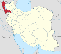
 Location of Urmia County in West Azerbaijan province (center, green) | |
 Location of West Azerbaijan province in Iran | |
| Coordinates: 37°45′N 45°03′E / 37.750°N 45.050°E / 37.750; 45.050[1] | |
| Country | |
| Province | West Azerbaijan |
| Capital | Urmia |
| Districts | Central, Anzal, Nazlu, Silvaneh, Sumay-ye Beradust |
| Population (2016)[2] | |
| • Total | 1,040,565 |
| Time zone | UTC+3:30 (IRST) |
| Urmia County can be found at GEOnet Names Server, at this link, by opening the Advanced Search box, entering "9205903" in the "Unique Feature Id" form, and clicking on "Search Database". | |
Urmia County (Persian: شهرستان ارومیه) is in West Azerbaijan province, Iran. Its capital is the city of Urmia.[3] The county is mainly populated by Kurds and Azeris.
At the 2006 census, the county's population was 856,914 in 215,342 households.[4] The following census in 2011 counted 963,738 people in 272,439 households.[5] At the 2016 census, the county's population was 1,040,565 in 304,306 households.[2]
Administrative divisions
The population history of Urmia County's administrative divisions over three consecutive censuses is shown in the following table. The latest census shows five districts, 20 rural districts, and five cities.[2]
| Administrative Divisions | 2006[4] | 2011[5] | 2016[2] |
|---|---|---|---|
| Central District | 702,376 | 806,861 | 879,709 |
| Bakeshluchay RD | 22,672 | 28,864 | 34,683 |
| Baranduz RD | 11,502 | 11,088 | 12,008 |
| Baranduzchay-ye Jonubi RD | 10,068 | 9,416 | 11,408 |
| Baranduzchay-ye Shomali RD | 7,466 | 7,529 | 8,486 |
| Bash Qaleh RD | 9,862 | 9,994 | 10,043 |
| Dul RD | 8,524 | 7,530 | 7,487 |
| Nazlu-ye Jonubi RD | 8,350 | 7,538 | 7,510 |
| Rowzeh Chay RD | 36,556 | 47,510 | 41,843 |
| Torkaman RD | 10,069 | 9,893 | 10,017 |
| Urmia (city) | 577,307 | 667,499 | 736,224 |
| Anzal District | 25,252 | 25,729 | 25,599 |
| Anzal-e Jonubi RD | 19,482 | 20,605 | 20,560 |
| Anzal-e Shomali RD | 2,938 | 2,598 | 2,252 |
| Qushchi (city) | 2,832 | 2,526 | 2,787 |
| Nazlu District | 36,732 | 39,495 | 39,701 |
| Nazlu-ye Shomali RD | 16,373 | 15,538 | 15,316 |
| Nazluchay RD | 10,624 | 14,455 | 13,727 |
| Tala Tappeh RD | 3,004 | 2,319 | 2,278 |
| Nushin (city) | 6,731 | 7,183 | 8,380 |
| Silvaneh District | 52,752 | 55,437 | 60,368 |
| Dasht RD | 8,647 | 9,012 | 10,199 |
| Margavar RD | 34,862 | 37,170 | 40,174 |
| Targavar RD | 7,893 | 7,765 | 8,381 |
| Silvaneh (city) | 1,350 | 1,490 | 1,614 |
| Sumay-ye Beradust District | 39,802 | 36,216 | 35,183 |
| Beradust RD | 13,766 | 11,593 | 11,361 |
| Sumay-ye Jonubi RD | 13,915 | 13,075 | 12,452 |
| Sumay-ye Shomali RD | 10,613 | 10,018 | 9,570 |
| Serow (city) | 1,508 | 1,530 | 1,800 |
| Total | 856,914 | 963,738 | 1,040,565 |
| RD: Rural District | |||
Wikimedia Commons has media related to Urmia County.
References
- ^ OpenStreetMap contributors (16 February 2024). "Urmia County" (Map). OpenStreetMap. Retrieved 16 February 2024.
- ^ a b c d "Census of the Islamic Republic of Iran, 1395 (2016)". AMAR (in Persian). The Statistical Center of Iran. p. 04. Archived from the original (Excel) on 30 August 2022. Retrieved 19 December 2022.
- ^ Habibi, Hassan (7 July 1369). "Approval of the organization and chain of citizenship of the elements and units of the country divisions of West Azerbaijan province, centered in the city of Urmia". Lamtakam (in Persian). Ministry of Interior, Council of Ministers. Archived from the original on 20 December 2023. Retrieved 20 December 2023.
- ^ a b "Census of the Islamic Republic of Iran, 1385 (2006)". AMAR (in Persian). The Statistical Center of Iran. p. 04. Archived from the original (Excel) on 20 September 2011. Retrieved 25 September 2022.
- ^ a b "Census of the Islamic Republic of Iran, 1390 (2011)". Syracuse University (in Persian). The Statistical Center of Iran. p. 04. Archived from the original (Excel) on 20 January 2023. Retrieved 19 December 2022.
