Tectonics of the Tian Shan

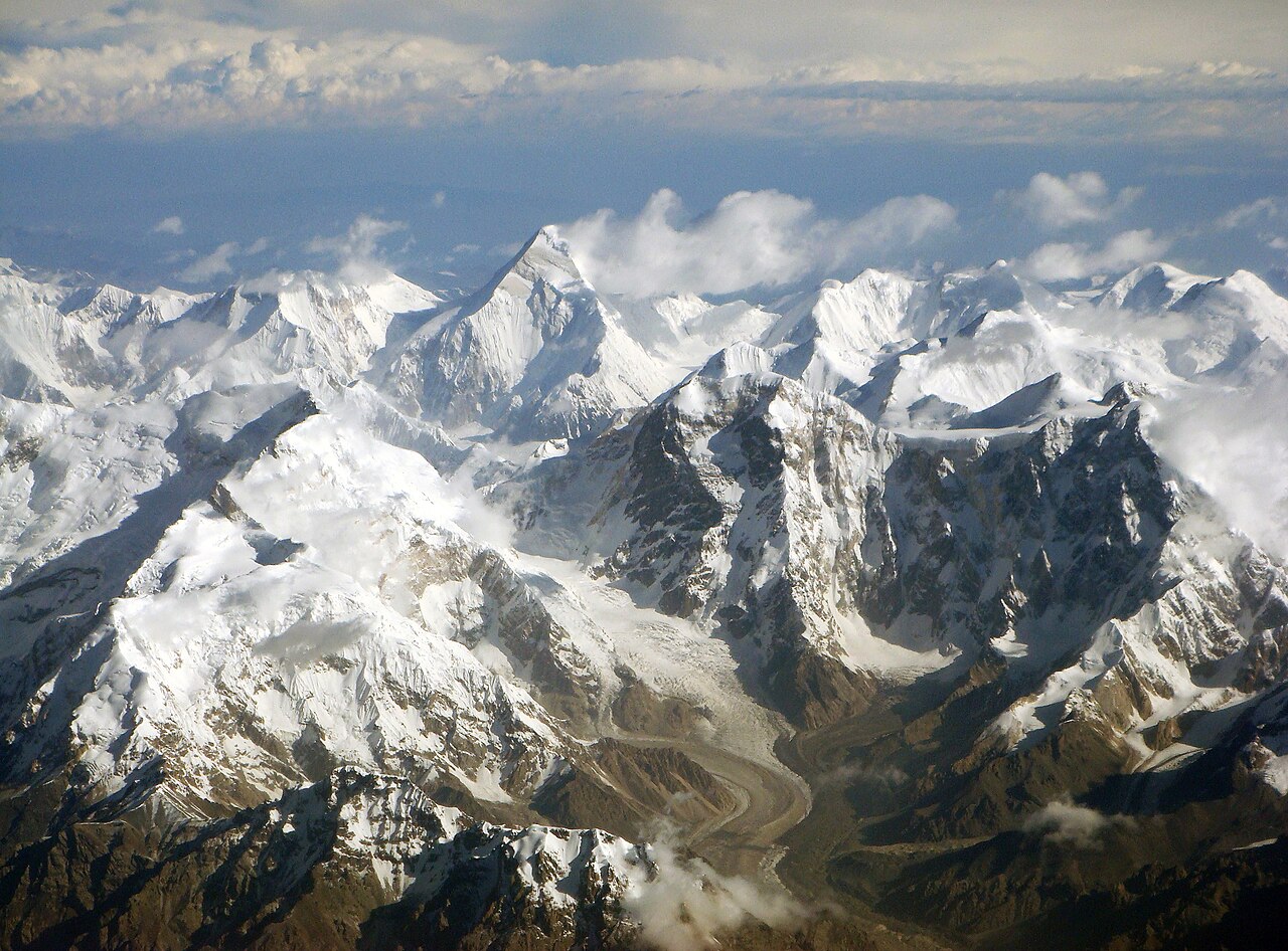
The Tian Shan is a mountain range in central Asia that extends through western China, Kazakhstan, and Kyrgyzstan.[1] The Tian Shan is 2,800 kilometres (1,700 mi) long, and up to 7,400 metres (24,300 ft) high. Throughout the Tian Shan there are several intermontane basins separated by high ranges.[1] Plate tectonic theory makes the assumption that deformation is concentrated along plate boundaries. However, active deformation is observed in the Tian Shan, far from plate boundaries. This apparent contradiction of plate tectonic theory makes the Tian Shan a key place to study the dynamics of intracontinental deformation.[2]
Tectonic history

The intracontinental weakness of Asia's interior has caused deformation in the Tian Shan Range after the collision of India into Asia.[4] However, the Tian Shan was uplifted prior to the Cenozoic Indo-Asia collision.
Paleozoic
The Tian Shan contains two late Paleozoic sutures.[3] The older, southern suture marks the collision of a passive margin at the north of the Tarim block and an active continental margin; subduction under the latter was to the north.[3] The late Paleozoic continent-continent collision along Tarim's northern margin created an orogenic belt along the southern part of the Tian Shan.[5] The younger, northern suture separates a northern Carboniferous island arc from an active continental margin developed over a south-dipping subduction zone.[3]
Mesozoic
Several fragments and island arcs collided with Asia's southern margin in the Mesozoic, creating deformation and uplift in the Tian Shan and Kunlun Shan, respectively to the north and south of the Tarim Basin.[6] Mesozoic deformation was minor or absent in most of the basin interior of the Tarim.[6]
Cenozoic
The collision of India with Asia is the latest major tectonic event to affect deformation in the Tian Shan.[7] Thrust faulting is the predominant style of Cenozoic deformation in the Tian Shan,[8] which propagated outward and rose progressively as a wedge-shaped block.[9] Dextral NW-SE trending strike slip faults either merge with or crosscut east-west trending thrust systems. The Talas-Fergana Fault is the longest of these structures.[10] Active deformation in the Tian Shan is the result of compressional stresses generated at the Indo-Asia collisional zone, where the Himalayas formed and continue to grow. Active deformation is observed in the Tian Shan, which is within Asia's continental interior, because Asia is not as internally rigid as the continental crust is expected to be.
Velocity field
Using geodetic techniques, GPS networks have been used in research to constrain the velocity field throughout the Tian Shan. This type of analysis helps illustrate the distribution of shortening rates throughout the region. Most of the convergence between the Tarim Basin and the Kazakh Platform is absorbed within the Tian Shan, with localized zones of shortening at rates of ~2 mm/yr to 6 mm/yr.[11] The total amount of convergence in the Tian Shan is not uniformly distributed across the range, with 80–90% of the North-South shortening absorbed along the southern and northern edges, and relatively little deformation accommodated within the interior.[9] The Chinese Tian Shan displays lateral variations in magnitudes of deformation, estimates range from 2.12 to 21 km of crustal shortening.[12] Slip rates on NW-SE trending strike-slip faults range from 1–4 mm/yr.[9] Slip rates on WE-SN trending gently-dipping detachment fault vary from 10–13 mm/yr for the southwest Tian Shan to 2–5 mm/y for eastern Tian Shan.[9] The velocity field indicates that the Tarim Basin is thrusting beneath the Tian Shan at ~4–7 mm/yr.[11] The velocity field also places a bound of ~4 mm/yr on the rate of crustal shortening across the Chatkal and neighboring ranges on the northwest margin of the Ferghana Valley, and they limit the present day slip rate on the right lateral Talas-Ferghana Fault to less than ~2 mm/yr[11]
Geologic subdivisions

Kuqa Foreland
The Kuqa Basin is bounded by the Tarim Basin to the south and the Tian Shan orogenic belt to the north. The Kuqa depression was probably part of the north Tarim continental margin at the Paleozoic time.[13] Under compressive tectonic loading and gravitational loading, the Kuqa depression became an intra-continental foreland basin. The cross-section of the basin is asymmetric and its depositional center lies close to the Tian Shan orogenic belt, the sediment thickness thins towards the Tarim craton.[13]
Borohoro Range
To the north, the Borohoro Range separates the Yili Basin from the North Tian Shan piedmont in the Junggar Basin.[14] On the southern and northern sides of the range, the basement is capped by Permian sediments, mainly carbonates.[1] The Borohoro Range is itself separated in two compartments by the small, elongated Hexilagen basin in which Early Jurassic coal series are exposed.[1]
Yili Basin
The Yili basin lies south of the Borohoro Range and is bordered by sutures and fault zones in the western Chinese Tian Shan belt.[15] During the Late Paleozoic, the northern boundary of the Yili basin was an active continental margin related to the southward subduction of the North Tianshan oceanic basin; this boundary is represented by Late Carboniferous turbidite and ophiolitic melange.[15] The southern and northern boundaries have been both reworked by Permian strike-slip faults.[15]
Issyk-Kul and Fergana Basins
The general strike of the Tian Shan ranges is East-Northeast, but there are significant deviations, especially near the major Talas-Fergana fault.[16] A striking feature of western Tian Shan is the large number of basins containing Cenozoic rocks, prominent basins include the Fergana Basin in the southwest, the Issyk-Kul Basin in the east and Naryn Basin in the south.[16] On the edges of the Tian Shan, there are foreland basins with Cenozoic sediments several kilometers thick. The Talas-Fergana fault is an active strike slip fault in which Quaternary offset is about 10 km and the total offset since the Paleozoic is about 200 km.[16]
References
- ^ a b c d e Jolivet, M.; Dominguez, S.; Charreau, J.; Chen, Y.; Li, Yongan; Wang, Qingchen (2010). "Mesozoic and Cenozoic Tectonic History of the Central Chinese Tian Shan: Reactivated Tectonic Structures and Active Deformation" (PDF). Tectonics. 29 (6): 1–30. Bibcode:2010Tecto..29.6019J. doi:10.1029/2010TC002712.
- ^ Wang, Bo; Shu, Liangshu; Faure, Michel; Jahn, Bor-ming; Cluzel, Dominique; Charvet, Jacques; Chung, Sun-lin; Meffre, Sébastien (16 November 2011). "Paleozoic tectonics of the southern Chinese Tianshan: Insights from structural, chronological and geochemical studies of the Heiyingshan ophiolitic mélange (NW China)" (PDF). Tectonophysics. 497 (1–4): 85–104. Bibcode:2011Tectp.497...85W. doi:10.1016/j.tecto.2010.11.004. S2CID 129664701.
- ^ a b c d Windley, B.F.; Allen, Mark B.; Zhang, Chi; Zhao, Z-Y; Wang, G-R (February 1990). "Paleozoic accretion and Cenozoic Redeformation of the Chinese Tien Shan Range, Central Asia". Geology. 18 (2): 128–131. Bibcode:1990Geo....18..128W. doi:10.1130/0091-7613(1990)018<0128:PAACRO>2.3.CO;2.
- ^ Molnar, Peter; Tapponnier, Paul (8 August 1975). "Cenozoic Tectonics of Asia: Effects of a Continental Collision". Science. 189 (4201): 419–426. Bibcode:1975Sci...189..419M. doi:10.1126/science.189.4201.419. JSTOR 1740465. PMID 17781869.
- ^ Allen, Mark B.; Windley, B. F.; Zhang, Chi (1992). "Palaeozoic collisional tectonics and magmatism of the Chinese Tien Shan, central Asia". Tectonophysics. 220 (1–4): 89–115. Bibcode:1993Tectp.220...89A. doi:10.1016/0040-1951(93)90225-9.
- ^ a b Allen, Mark B.; Windley, B. F.; Zhang, Chi (1994). "Cenozoic tectonics in the Urumqi-Korla region of the Chinese Tien Shan". Active Continental Margins — Present and Past. Vol. 83. pp. 406–416. doi:10.1007/978-3-662-38521-0_15. ISBN 978-3-662-37709-3.
{{cite book}}:|journal=ignored (help) - ^ Hendrix, Marc S.; Graham, Stephan A.; Carroll, Alan R.; Sobel, Edward R.; Mcknight, Cleavy L.; Schulein, Benjamin J.; Wang, Zuoxun (1992). "Sedimentary Record and Climatic Implications of Recurrent Deformation in the Tian Shan: Evidence from Mesozoic strata of the north Tarim, south Junggar, and Turpan basins, northwest China". Geological Society of America Bulletin. 104 (1): 53–79. Bibcode:1992GSAB..104...53H. doi:10.1130/0016-7606(1992)104<0053:SRACIO>2.3.CO;2.
- ^ Yin, A.; Nie, S.; Craig, P.; Harrison, T. M.; Ryerson, F. J.; Xianglin, Qian; Geng, Yang (February 1998). "Late Cenozoic Tectonic Evolution of the Southern Chinese Tian Shan". Tectonics. 17 (1): 1–27. Bibcode:1998Tecto..17....1Y. doi:10.1029/97TC03140.
- ^ a b c d Yang, Shao Min; Li, Jie Li and Qi Wang; Wang, Qi (August 2008). "Deformation Pattern and Fault Rate in the Tianshan Mountains Inferred from GPS Observations". Science in China Series D: Earth Sciences. 51 (8): 1064–1080. Bibcode:2008ScChD..51.1064Y. doi:10.1007/s11430-008-0090-8. S2CID 130813076.
- ^ Allen, Mark B.; Vincent, Stephen J.; Wheeler, Paul J. (August 1999). "Late Cenozoic tectonics of the Kepingtage Thrust Zone". Tectonics. 18 (4): 639–654. Bibcode:1999Tecto..18..639A. doi:10.1029/1999TC900019. S2CID 129437304.
- ^ a b c Zubovich, Alexander V.; Wang, Xiao-qiang; Scherba, Yuri G.; Schelochkov, Gennady G.; Reilinger, Robert; Reigber, Christoph; Mosienko, Olga I.; Molnar, Peter; Michajljow, Wasili; Makarov, Vladimir I.; Li, Jie; Kuzikov, Sergey I.; Herring, Thomas A.; Hamburger, Michael W.; Hager, Bradford H.; Dang, Ya-min; Bragin, Vitaly D.; Beisenbaev, Rinat T. (December 2010). "GPS Velocity Field for the Tien Shan and Surrounding Regions". Tectonics. 29 (6): n/a. Bibcode:2010Tecto..29.6014Z. doi:10.1029/2010TC002772. hdl:1721.1/75344. S2CID 2607826.
- ^ Burchfiel, B. C.; Brown, E. T.; Deng, Qidong; Feng, Xianyue; Li, Jun; Molnar, Peter; Shi, Jianbang; Wu, Zhangming; You, Huichuang (1999). "Crustal Shortening on the Margins of the Tien Shan, Xinjiang, China". International Geology Review. 41 (8): 665–700. Bibcode:1999IGRv...41..665B. doi:10.1080/00206819909465164.
- ^ a b Jia, Dong; Lu, Huafu; Cai, Dongsheng; Wu, Shimin; Shi, Yangshen; Chen, Chuming (1998). "Structural Features of Northern Tarim Basin: Implications for Regional Tectonics and Petroleum Traps". AAPG Bulletin. 81 (1): 147–159. doi:10.1306/1d9bc3b3-172d-11d7-8645000102c1865d.
- ^ Zhou, Da; Graham, Stephan A.; Chang, Edmund Z.; Wang, Baoyu; Hacker, Bradley (2001). "Paleozoic tectonic amalgamation of the Chinese Tian Shan: Evidence from a transect along the Dushanzi-Kuqa Highway". Paleozoic and Mesozoic tectonic evolution of central Asia: from continental assembly to intracontinental deformation. Vol. 194. pp. 71–99. doi:10.1130/0-8137-1194-0.23. ISBN 978-0-8137-1194-2.
{{cite book}}:|periodical=ignored (help) - ^ a b c Wang, Bo; Faure, Michel; Shu, Liangshu; Cluzel, Dominique; Charvet, Jacques; De Jong, Koen; Chen, Yan (September 2008). "Paleozoic tectonic evolution of the Yili Block, western Chinese Tianshan". Bulletin de la Société Géologique de France. 179 (5): 483–490. doi:10.2113/gssgfbull.179.5.483.
- ^ a b c Cobbold, P.R.; Sadybakasov, E.; Thomas, J.C. (1994). "Cenozoic Transpression and Basin Development, Kyrghyz Tienshan Central Asia". In Roure, F.; Ellouz, N.; Shein, V. S.; et al. (eds.). Geodynamic Evolution of Sedimentary Basins. International Symposium. Moscow, May 18–23, 1992: Éditions Technip, Paris. pp. 181–202. ISBN 2-7108-0692-4.
{{cite conference}}: CS1 maint: location (link)