Sylva (river)
| Sylva | |
|---|---|
 River Sylva in the Urals | |
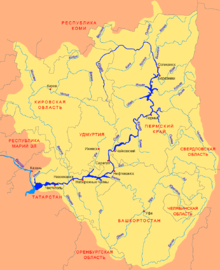
 Scheme of the Kama River Basin. | |
| Location | |
| Country | Russia |
| Physical characteristics | |
| Source | |
| • location | Middle Urals |
| Mouth | |
• location | Chusovaya |
• coordinates | 58°06′28″N 56°38′16″E / 58.10778°N 56.63778°E / 58.10778; 56.63778 |
| Length | 493 km (306 mi) |
| Basin size | 19,700 km2 (7,600 sq mi) |
| Discharge | |
| • average | 139 m3/s (4,900 cu ft/s) |
| Basin features | |
| Progression | Chusovaya→ Kama→ Volga→ Caspian Sea |
The Sylva (Russian: Сылва) is a river in Sverdlovsk Oblast and Perm Krai in Russia. It is 493 kilometres (306 mi) in length.[1] The area of the basin is 19,700 square kilometres (7,600 sq mi).[2] The Sylva flows into the Chusovoy Cove of the Kama Reservoir. It freezes up in November and stays under the ice until April. Principal tributaries: Iren, Babka, Irgina, Vogulka (left); Barda, Shakva (right).[2] Main port: Kungur.
Every year hundreds of tourists come to Kungur, through routes down the Sylva, Iren and Shakva rivers. The Sylva River flows leisurely over a flat plateau, across Preduraliye Nature Preserve, and past abrupt cliffs, fossilized remnants of coral reefs left by the long-disappeared Great Permian Sea, which at some places rise up to 100 metres (330 ft) above the level of the river, covered with pine and fir groves.
Inhabited localities
References
- ^ Сылва (река) in the Great Soviet Encyclopedia, 1969–1978 (in Russian)
- ^ a b "Государственный водный реестр РФ: Сылва".
