Rural Municipality of Portage la Prairie
Rural Municipality of Portage la Prairie | |
|---|---|
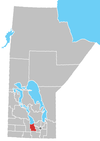
 Location of the RM of Portage la Prairie in Manitoba | |
| Coordinates: 50°02′56″N 98°12′58″W / 50.04889°N 98.21611°W / 50.04889; -98.21611 | |
| Country | Canada |
| Province | Manitoba |
| Area [1] | |
| • Land | 1,961.97 km2 (757.52 sq mi) |
| Population (2016)[1] | |
| • Total | 6,975 |
| Time zone | UTC-6 (CST) |
| • Summer (DST) | UTC-5 (CDT) |
| Area codes | 204 and 431 |
Portage la Prairie is a rural municipality (RM) in the province of Manitoba in Western Canada. It surrounds the city of Portage la Prairie, Manitoba's fifth-largest city. Also within the borders of the municipality are the Dakota Plains First Nation and most of the Long Plain First Nation Indian reserves.
Communities
- Bloom
- Curtis
- Delta Beach
- Edwin
- Fortier
- Fulton
- High Bluff
- Layland
- Longburn
- Macdonald
- Newton
- Oakland
- Oakville
- Poplar Point
- Rignold
- St. Ambroise
- Southport
Demographics
In the 2021 Census of Population conducted by Statistics Canada, Portage la Prairie had a population of 6,888 living in 2,167 of its 2,456 total private dwellings, a change of -1.2% from its 2016 population of 6,975. With a land area of 1,973.45 km2 (761.95 sq mi), it had a population density of 3.5/km2 (9.0/sq mi) in 2021.[2]
References
- ^ a b "Population and dwelling counts, for Canada, provinces and territories, and census subdivisions (municipalities), 2016 and 2011 censuses – 100% data (Manitoba)". Statistics Canada. February 7, 2018. Retrieved January 15, 2022.
- ^ "Population and dwelling counts: Canada, provinces and territories, and census subdivisions (municipalities), Manitoba". Statistics Canada. February 9, 2022. Retrieved February 20, 2022.
External links
- Official website
- Map of Portage la Prairie R.M. at Statcan
