Rupat
This article needs additional citations for verification. (June 2014) |
Native name: Palau Rupat (Indonesian) | |
|---|---|
 Ketapang Beach | |
| Geography | |
| Location | Strait of Malacca |
| Coordinates | 1°54′N 101°36′E / 1.900°N 101.600°E / 1.900; 101.600 |
| Area | 1,523.7 km2 (588.3 sq mi) |
| Administration | |
Indonesia | |
| Demographics | |
| Population | 50,195 (2022) |
| Pop. density | 33/km2 (85/sq mi) |
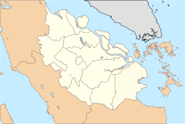
Rupat (Indonesian: Pulau Rupat) is an island in the Strait of Malacca, and forms part of Bengkalis Regency within Riau, Indonesia. It lies just off the eastern coast of Sumatra, across from Dumai city, from which it is separated by the Rupat Strait (Indonesian: Selat Rupat). Its area is 1,523.7 km2 (588.3 sq mi). The island is sparsely populated (50,195 in mid-2022), with a population density of 33 per km2. Rupat was one of thousands of abandoned islands, but its population is growing yearly, which has made the government expand the area for the settlement.
There is a proposal by the Malaysian government with Chinese financial backing to build a bridge from Melaka to Rupat and thence to Dumai, to be called the Malacca Strait Bridge, though Jakarta seems to prefer to build the Sunda Strait Bridge first.
Raptor bird migration
Together with the Sangihe Islands, Rupat is located in the East Asian-Australasian Flyway, a corridor used by bird of prey for migration. 24 of the 56 kinds of Asian raptors can be found in both locations. From September to November, up to 2,000 raptors migrate to Rupat every day, while migration out happens from February to April.[1]
References
- ^ "Pulau Rupat Habitat Penting Raptor Asia". December 29, 2013.
1°54′N 101°36′E / 1.900°N 101.600°E / 1.900; 101.600

