Curse of the Colonel refers to an urban legend regarding a reputed curse placed on the Japanese Kansai-basedHanshin Tigersbaseball team by deceased KFC founder and mascotColonel Harland Sanders. The curse was said to be placed on the team because of the Colonel's anger over treatment of one of his store-front statues. As is common with sports-related curses, the Curse of the Colonel is used to explain the Japan Championship Series drought that the Hanshin Tigers have had to endure since their first and only victory in the 1985 Japan Championship. The curse is a classic example of a scapegoat. The Hanshin Tigers are located in Kansai, the second largest metropolitan area in Japan. They are considered the eternal underdogs of Nippon Professional Baseball, in opposition to the Yomiuri Giants of Tokyo, who are considered the kings of Japanese baseball. The devoted fans flock to the stadium no matter how badly the Tigers play in the league. Comparisons are often made between the Hanshin Tigers and the Boston Red Sox, who were also said to be under a curse, the Curse of the Bambino, until they won the World Series in 2004. In 1985, much to Japanese people's surprise, the Hanshin Tigers faced the Seibu Lions and took their first and only victory in the Japan Series, largely due to star slugger Randy Bass, a gaijin (foreigner) player for the team. (Full article...)
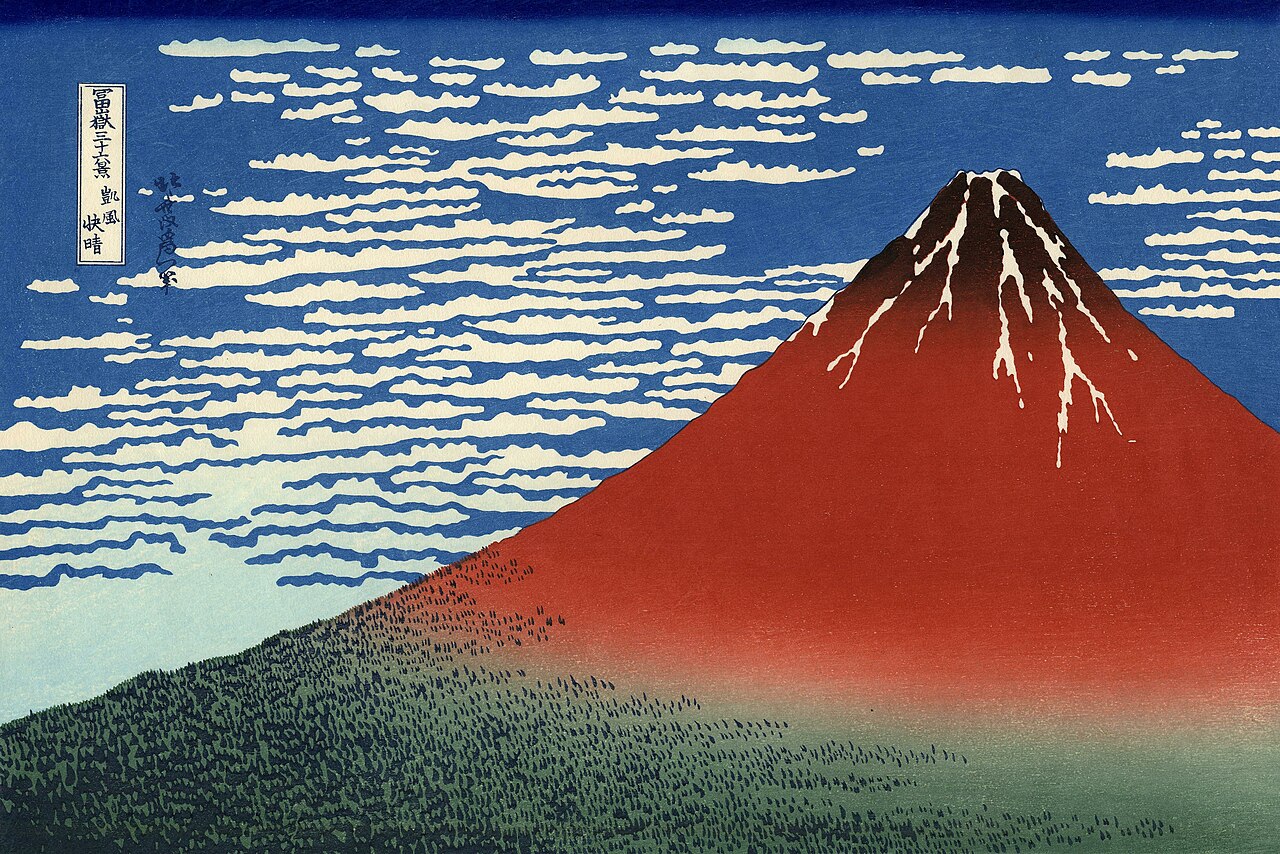
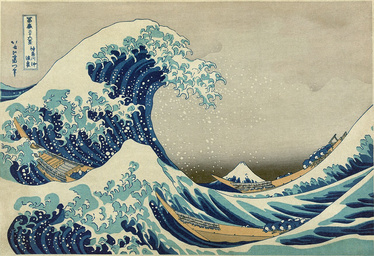
Hokusai's South Wind, Clear Sky (also known as Red Fuji), from his seminal work 36 Views of Mount Fuji, is one of the most iconic representations of the Japanese style of art known as ukiyo-e.
The siege of Osaka was a series of battles undertaken by the Japanese Tokugawa shogunate against the Toyotomi clan, and ending in the clan's dissolution. Divided into two stages (the winter campaign and the summer campaign), and lasting from 1614 to 1615, the siege put an end to the last major armed opposition to the shogunate's establishment. This eight-metre-long (26 ft) painting, titled The Summer Battle of Osaka Castle and executed on a Japanese folding screen, illustrates Osaka Castle under siege, and was commissioned by the daimyoKuroda Nagamasa, who took a team of painters with him to the battlefield to record the event. The painting depicts 5071 people and 21 generals, and is held in the collection of Osaka Castle.
A registration card for Louis Wijnhamer (1904–1975), an ethnic Dutch humanitarian who was captured soon after the Empire of Japan occupied the Dutch East Indies in March 1942. Prior to the occupation, many ethnic Europeans had refused to leave, expecting the Japanese occupation government to keep a Dutch administration in place. When Japanese troops took control of government infrastructure and services such as ports and postal services, 100,000 European (and some Chinese) civilians were interned in prisoner-of-war camps where the death rates were between 13 and 30 per cent. Wijnhamer was interned in a series of camps throughout Southeast Asia and, after the surrender of Japan, returned to what was now Indonesia, where he lived until his death.
The Japanese government-issued dollar was a form of currency issued between 1942 and 1945 for use within the territories of Singapore, Malaya, North Borneo, Sarawak and Brunei, under occupation by Imperial Japan during World War II. The currency, informally referred to as "banana money", was released solely in the form of banknotes, as metals were considered essential to the war effort. The languages used on the notes were reduced to English and Japanese. Each note bears a different obverse and reverse design, but all have a similar layout, and were marked with stamped block letters that begin with "M" for "Malaya". This 1942 ten-cent Japanese-issued banknote is part of the National Numismatic Collection at the Smithsonian Institution.
Other denominations: '"`UNIQ--templatestyles-0000000D-QINU`"'
Asahi Breweries is a Japanese global beer, spirits, soft drinks and food business group. This photograph, taken during the blue hour with a full moon, shows the headquarters of Asahi Breweries in Sumida, Tokyo, as viewed from the wharf on the Sumida River near Azuma Bridge. The Asahi Beer Hall, topped by the Asahi Flame, designed by Philippe Starck, is visible on the right, with the Tokyo Skytree in the background on the left.
Image 12
A Buddhist temple ruined after the atomic bomb attack on Nagasaki
The destroyed remains of a Buddhist temple in Nagasaki, Japan. This picture was taken on September 24, 1945, six weeks after the city was destroyed by the world's secondatomic bomb attack.
Flowering Plum Tree (after Hiroshige), a copy of the ukiyo-e woodblock print Plum Park in Kameido by the Japanese artist Hiroshige. Completed in 1887, this painting is one of several Japanese-influenced works created by Vincent van Gogh after the opening up of Japan. In his copy, van Gogh ignored the shading present in the trunk and background of Hiroshige's image, which there implied age, and instead used colours with more "passion" and "youthfulness".
Banknotes: Empire of Japan. Reproduction: National Numismatic Collection, National Museum of American History at the Smithsonian Institution
The Japanese-issued Netherlands Indies gulden was the currency issued by the Japanese Empire when it occupied the Dutch East Indies during World War II. Following the Dutch capitulation in March 1942, the Japanese closed all banks, seized assets and currency, and assumed control of the economy in the territory. They began issuing military banknotes, as had previously been done in other occupied territories. These were printed in Japan, but retained the name of the pre-war currency and replaced the Dutch gulden at par. From 1943 the military banknotes were replaced by identical bank-issued notes printed within the territory, and the currency was renamed the roepiah from 1944. The currency was replaced by the Indonesian rupiah in 1946, one year after the Japanese surrender and the country's independence.
This note, denominated five cents, is part of the 1942 series.
Before the outbreak of World War I, German naval ships were located in the Pacific; Tsingtao developed into a major seaport while the surrounding Kiautschou Bay area was leased to Germany since 1898. During the war, Japanese and British Allied troops besieged the port in 1914 before capturing it from the German and Austro-Hungarian Central Powers, occupying the city and the surrounding region. It served as a base for the exploitation of the natural resources of Shandong province and northern China, and a "New City District" was established to furnish the Japanese colonists with commercial sections and living quarters. Tsingtao eventually reverted to Chinese rule by 1922.
Japan increases its four-stage danger ranking level for most of Iran, including Tehran, to Level 3, which urges Japanese citizens to avoid all travel to Iran. (The Japan News)
A magnitude 7.4 earthquake strikes off the coast of Taiwan, prompting tsunami warnings for Okinawa Prefecture, Japan. A large section of the uninhabited Guishan Island collapses into the ocean. Nine people are killed in Taiwan, including four by rockfalls, with more than 930 others injured. (AP) (Al Jazeera)
Fukuzawa was an early advocate for reform in Japan. His ideas about the organization of government and the structure of social institutions made a lasting impression on a rapidly changing Japan during the Meiji period. He appears on the current 10,000-Japanese yen banknote. (Full article...)
Aichi Prefecture is a prefecture of Japan located in the Tokai region of the Chūbu region. The capital is Nagoya. It is the focus of the Chūkyō Metropolitan Area. Originally, the region was divided into the three provinces of Owari, Mikawa and Ho. After the Nou-sama era, Mikawa and Ho were united into a single entity. In 1871, after the abolition of the han system, Owari, with the exception of the Chita Peninsula, was institutionalized as Nagoya Prefecture, while Mikawa combined with the Chita Peninsula and formed Nukata Prefecture. Nagoya Prefecture was renamed to Aichi Prefecture in April 1872, and was united with Nukata Prefecture on November 27 of the same year. The Expo 2005World Exposition was held in Seto and Nagakute. Located near the center of the Japanese main island of Honshū, Aichi Prefecture faces the Ise and Mikawa Bays to the south and borders Shizuoka to the east, Nagano to the northeast, Gifu to the north, and Mie to the west. It measures 106 km east to west and 94 km south to north and forms a major portion of the Nōbi Plain. With 5,153.81 km² it accounts for approximately 1.36% of the total surface area of Japan. The highest spot is Chausuyama at 1415 m above sea level. The western part of the prefecture is dominated by Nagoya, Japan's fourth largest city, and its suburbs, while the eastern part is relatively less densely populated but still contains several major industrial centers. Due to its robust economy, for the Oct 2005-Oct 2006 period, Aichi was the fastest growing prefecture in terms of population, beating Tokyo, at 7.4%.
Image 24A social hierarchy chart based on old academic theories. Such hierarchical diagrams were removed from Japanese textbooks after various studies in the 1990s revealed that peasants, craftsmen, and merchants were in fact equal and merely social categories. Successive shoguns held the highest or near-highest court ranks, higher than most court nobles. (from History of Japan)
Image 38The Kuril Islands, with their Russian names. The borders of the Treaty of Shimoda (1855) and the Treaty of St. Petersburg (1875) are shown in red. Currently, all islands northeast of Hokkaido are administered by Russia. (from Geography of Japan)
Image 55Relief map of the land and the seabed of Japan. It shows the surface and underwater terrain of the Japanese archipelago. (from Geography of Japan)
Image 58Japanese experts inspect the scene of the alleged railway sabotage on South Manchurian Railway that led to the Mukden Incident and the Japanese occupation of Manchuria. (from History of Japan)
Image 61Minamoto no Yoritomo was the founder of the Kamakura shogunate in 1192. This was the first military government in which the shogun with the samurai were the de facto rulers of Japan. (from History of Japan)
Image 62Japanese archipelago with outlined islands (from Geography of Japan)
Image 63Map showing the territories of major daimyō families around 1570 CE (from History of Japan)
Image 65Mount Aso 4 pyroclastic flow and the spread of Aso 4 tephra (90,000 to 85,000 years ago). The pyroclastic flow reached almost the whole area of Kyushu, and volcanic ash was deposited of 15 cm in a wide area from Kyushu to southern Hokkaido. (from Geography of Japan)
Image 87Samurai could kill a commoner for the slightest insult and were widely feared by the Japanese population. Edo period, 1798. (from History of Japan)
This is a list of recognized content, updated weekly by JL-Bot (talk·contribs) (typically on Saturdays). There is no need to edit the list yourself. If an article is missing from the list, make sure it is tagged (e.g. {{WikiProject Japan}}) or categorized correctly and wait for the next update. See WP:RECOG for configuration options.


.jpg/1280px-BUR-17b-Burma-Japanese_Occupation-100_Rupees_ND_(1944).jpg)


.jpg/1280px-MAL-M9-Malaya-Japanese_Occupation-100_Dollars_ND_(1945).jpg)


.jpg/1280px-NI-124c-Netherlands_Indies-Japanese_Occupation-5_Gulden_(1942).jpg)
.jpg/1280px-JAPAN-M7-Tsingtao-10_Sen_(1914).jpg)


.svg)


.jpg/1280px-Sekigahara_Kassen_By%C5%8Dbu-zu_(Gifu_History_Museum).jpg)


.jpg/1280px-Fumie_Hihara,_au_shamisen_(danse_du_Kabuki,_mus%C3%A9e_Guimet).jpg)


.jpg/1280px-%E5%89%A3%E9%AD%82_%E5%BA%83%E5%B3%B6%E5%A4%A7%E5%AD%A6%E4%BD%93%E8%82%B2%E4%BC%9A%E5%89%A3%E9%81%93%E9%83%A8_2005_(9014981997).jpg)


_Classic_hatchback_01.jpg/1280px-2003_Mazda_6_(GG)_Classic_hatchback_01.jpg)

.jpg/1280px-BUR-10b-Burma-Japanese_Occupation-Five_Cents_ND_(1942).jpg)
.jpg/1280px-BUR-11a-Burma-Japanese_Occupation-10_Cents_ND_(1942).jpg)
.jpg/1280px-BUR-12a-Burma-Japanese_Occupation-One_Quarter_Rupee_ND_(1942).jpg)
.jpg/1280px-BUR-13b-Burma-Japanese_Occupation-One_Half_Rupee_ND_(1942).jpg)
.jpg/1280px-BUR-14-Burma-Japanese_Occupation-One_Rupee_ND_(1942).jpg)
.jpg/1280px-BUR-15b-Burma-Japanese_Occupation-Five_Rupees_ND_(1942-44).jpg)
.jpg/1280px-BUR-16-Japanese_occupation_Burma-10_rupees_(1942-44).jpg)
.jpg/1280px-BUR-9b-Burma-Japanese_Occupation-One_Cent_ND_(1942).jpg)
.jpg/1280px-Bicycle_crankset_Shimano_105_R7000_(chainring_50-34,_length_172.5mm,_11_speed).jpg)


.jpg/1280px-Comme_des_Garcons_at_the_Met_(62473).jpg)


.png)

_-_left_hand_screen.jpg/1280px-Hasegawa_Tohaku_-_Pine_Trees_(Sh%C5%8Drin-zu_by%C5%8Dbu)_-_left_hand_screen.jpg)
_-_right_hand_screen.jpg/1280px-Hasegawa_Tohaku_-_Pine_Trees_(Sh%C5%8Drin-zu_by%C5%8Dbu)_-_right_hand_screen.jpg)


.jpg/1280px-JAPAN-10-Constitutional_Monarchy-One_Yen_(1873).jpg)
.jpg/1280px-Japan_1870_20_Yen_(alt).jpg)


.jpg/1280px-MAL-M10b-Malaya-Japanese_Occupation-1000_Dollars_ND_(1945).jpg)
.jpg/1280px-MAL-M1b-Malaya-Japanese_Occupation-One_Cent_ND_(1942).jpg)
.jpg/1280px-MAL-M2a-Malaya-Japanese_Occupation-Five_Cents_ND_(1942).jpg)
.jpg/1280px-MAL-M3b-Malaya-Japanese_Occupation-10_Cents_ND_(1942).jpg)
.jpg/1280px-MAL-M4b-Malaya-Japanese_Occupation-50_Cents_ND_(1942).jpg)
.jpg/1280px-MAL-M5c-Malaya-Japanese_Occupation-One_Dollar_ND_(1942).jpg)
.jpg/1280px-MAL-M6c-Malaya-Japanese_Occupation-Five_Dollars_ND_(1942).jpg)
.jpg/1280px-MAL-M7c-Malaya-Japanese_Occupation-10_Dollars_ND_(1944).jpg)
.jpg/1280px-MAL-M8b-Malaya-Japanese_Occupation-100_Dollars_ND_(1944).jpg)


.jpg/1280px-NI-119b-Netherlands_Indies-Japanese_Occupation-1_Cent_(1942).jpg)
.jpg/1280px-NI-120c-Netherlands_Indies-Japanese_Occupation-5_Cents_(1942).jpg)
.jpg/1280px-NI-121a-Netherlands_Indies-Japanese_Occupation-10_Cents_(1942).jpg)
.jpg/1280px-NI-122b-Netherlands_Indies-Japanese_Occupation-half_Gulden_(1942).jpg)
.jpg/1280px-NI-123-Netherlands_Indies-Japanese_Occupation-1_Gulden_(1942).jpg)
.jpg/1280px-NI-125c-Netherlands_Indies-Japanese_Occupation-10_Gulden_(1942).jpg)

.jpg/1280px-Nagoya_Castle(Edit2).jpg)

.jpg/1280px-OCE-1a-Oceania-Japanese_Occupation-Half_Shilling_ND_(1942).jpg)
.jpg/1280px-OCE-2a-Oceania-Japanese_Occupation-One_Shilling_ND_(1942).jpg)
.jpg/1280px-OCE-3a-Oceania-Japanese_Occupation-10_Shillings_ND_(1942).jpg)
.jpg/1280px-OCE-4a-Oceania-Japanese_Occupation-One_Pound_ND_(1942).jpg)


-1_Centavo_(1942).jpg/1280px-PHI-102b-Japanese_Government_(Philippines)-1_Centavo_(1942).jpg)
-5_Centavos_(1942).jpg/1280px-PHI-103b-Japanese_Government_(Philippines)-5_Centavos_(1942).jpg)
-10_Centavos_(1942).jpg/1280px-PHI-104b-Japanese_Government_(Philippines)-10_Centavos_(1942).jpg)
-50_Centavos_(1942).jpg/1280px-PHI-105b-Japanese_Government_(Philippines)-50_Centavos_(1942).jpg)
-1_Peso_(1942).jpg/1280px-PHI-106-Japanese_Government_(Philippines)-1_Peso_(1942).jpg)
-5_Pesos_(1942).jpg/1280px-PHI-107A-Japanese_Government_(Philippines)-5_Pesos_(1942).jpg)
-10_Pesos_(1942).jpg/1280px-PHI-108-Japanese_Government_(Philippines)-10_Pesos_(1942).jpg)
-1_Peso_(1943).jpg/1280px-PHI-109-Japanese_Government_(Philippines)-1_Peso_(1943).jpg)
-5_Pesos_(1943).jpg/1280px-PHI-110-Japanese_Government_(Philippines)-5_Pesos_(1943).jpg)
-10_Pesos_(1943).jpg/1280px-PHI-111-Japanese_Government_(Philippines)-10_Pesos_(1943).jpg)
-100_Pesos_(1944).jpg/1280px-PHI-112-Japanese_Government_(Philippines)-100_Pesos_(1944).jpg)
-500_Pesos_(1944).jpg/1280px-PHI-114-Japanese_Government_(Philippines)-500_Pesos_(1944).jpg)
-1000_Pesos_(1945).jpg/1280px-PHI-115-Japanese_Government_(Philippines)-1000_Pesos_(1945).jpg)

.jpg/1280px-Rhinogobius_flumineus(Hamamatsu,Shizuoka,Japan).jpg)


.jpg)
.jpg)
.jpg)
.jpg)
.jpg)
.jpg)
.jpg)
_Classic_hatchback_01.jpg)
.jpg)
.jpg)
.jpg)
.jpg)
.jpg)
.jpg)
.jpg)
.jpg)
.jpg)
.jpg)
_-_left_hand_screen.jpg)
_-_right_hand_screen.jpg)
.jpg)
.jpg)
.jpg)
.jpg)
.jpg)
.jpg)
.jpg)
.jpg)
.jpg)
.jpg)
.jpg)
.jpg)
.jpg)
.jpg)
.jpg)
.jpg)
.jpg)
.jpg)
.jpg)
.jpg)
.jpg)
.jpg)
-1_Centavo_(1942).jpg)
-5_Centavos_(1942).jpg)
-10_Centavos_(1942).jpg)
-50_Centavos_(1942).jpg)
-1_Peso_(1942).jpg)
-5_Pesos_(1942).jpg)
-10_Pesos_(1942).jpg)
-1_Peso_(1943).jpg)
-5_Pesos_(1943).jpg)
-10_Pesos_(1943).jpg)
-100_Pesos_(1944).jpg)
-500_Pesos_(1944).jpg)
-1000_Pesos_(1945).jpg)
.jpg)