Portal:Geography/Featured picture archive/2007
2007 Selected pictures
Week 1
 |
|
Pressure release of granite in the Enchanted Rock State Natural Area of Texas, United States. The photo shows the geological exfoliation of granite dome rock. Photo credit: Taken by Wing-Chi Poon on 2nd April 2005 |
Week 2
 |
|
The trail of underwater mountains created as the tectonic plate moved across the Hawaii hotspot over millions of years, known as the Hawaiian-Emperor seamount chain, or the Emperor Seamounts. Photo credit: NOAA |
Week 3
 |
|
Generation of a tsunami. Image credit: Anthony Liekens, Koba-chan |
Week 4
 |
|
Cumulonimbus capillatus incus cloud, floating over Swifts Creek, Victoria in Australia. Image credit: Fir0002 |
Week 5
 |
|
A hygrometer is used to measure the relative humidity. Image credit: José Cruz/Agência Brasil |
Week 6
 |
|
Tonoshō port in Shodoshima Island Kagawa Prefecture, Japan at night. Photo credit: 663highland 2006.10.28 |
Week 7
 |
|
Drake Park, Bend, Oregon, United States on 27 December 2004. Photo credit: Erik Swanson |
Week 8
 |
|
Mount Hood reflected in Mirror Lake, Oregon. Photo credit: Oregon's Mt. Hood Territory |
Week 9
 |
|
Great Wall of China at Mutianyu. Photo credit: Ofol |
Week 10
 |
|
Photo credit: Júlio Reis and João David Tereso |
Week 11
 |
|
Whale watching ships in Húsavík, Iceland. Photo credit: Andreas Tille |
Week 12
 |
|
The Earth's tectonic plates. Image credit: AzaToth, USGS |
Week 13
 |
|
Mouth of the glacier Schlatenkees, near Innergschlöß and Alte Prager Hütte, Austria. Image credit: SehLax |
Week 14
 |
|
Winter scene at Shipka Pass in Bulgaria. Image credit: Psy guy |
Week 15
 |
|
Cyclone Catarina. Note the clockwise circulation of Southern Hemisphere cyclones, the well-defined banding features, and the eyewall of at least a Category 1 system. The coastline is visible under the clouds in the upper left corner of the image. Image credit: Astronaut photograph ISS008-E-19646 was taken March 7, 2004 on the International Space Station, provided by the Earth Observations Laboratory, Johnson Space Center. |
Week 16
 |
|
Northern shore meadows of Sihlsee, an artificial lake near Einsiedeln in the Canton of Schwyz, Switzerland. Image credit: Markus Bernet |
Week 17
|
Thirty-three arch bridge aka. Si-o-se Pol, built over the Zayandeh River in Isfahan, Iran. Image credit: Marmoulak |
Week 18
|
Colorful reef fish, Pennant coralfish, Pyramid and Milletseed butterflyfish, school in great numbers at Rapture Reef, French Frigate Shoals of the Northwestern Hawaiian Islands. Image credit: U.S. National Oceanic and Atmospheric Administration |
Week 19
 |
|
Landscape produced by a receding glacier. Image credit: Luis María Benítez, Lycaon (vectorisation) |
Week 20
 |
|
Husum harbour, North Germany in March 2005. Image credit: Atelier Joly |
Week 21
Week 22
 |
|
Burnt forest 15th June 2004 along Rocky Point Trail, McDonald Lake region, Glacier National Park, Montana, USA. This photo vividly shows a burnt forest. The forest fire happened one year ago in summer 2003. Some rare woodpeckers only inhabit recently burnt forest; the burnt forest also provides a chance for botanist to study plant succession in a dramatically altered ecosystem, and for geologists to study the landscape without being covered by vegetation. Image credit: Wing-Chi Poon |
Week 23
 |
|
Sunset in the Namib-Naukluft National Park in Namibia. Image credit: Patrick Giraud |
Week 24
 |
|
Bathymetric map of Indian Ocean. Image credit: NASA |
Week 25
 |
|
Smog in Beijing, China in August 2005. The photo on the right was taken during a sunny, otherwise clear day, the photo on the left was taken on another day, after it had rained for approximately 2 days. Both of these photos were taken in the morning around the 07:00-08:00 hour. Image credit: Bobak Ha'Eri |
Week 26
 |
|
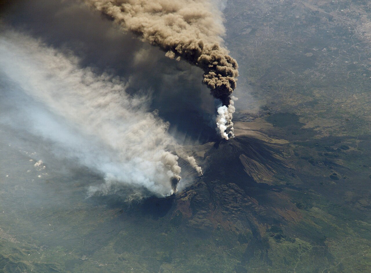
The 30 October, 2002 Mount Etna eruption as seen from the International Space Station. Image credit: NASA |
Week 27
 |
|
Bridge across the Volga River near Ulyanovsk, Russia. Image credit: Olegivvit |
Week 28
 |
|
A massive sand storm cloud is close to enveloping a military camp as it rolls over Al Asad, Iraq, just before nightfall on April 27, 2005. Image credit: Corporal Alicia M. Garcia, U.S. Marine Corps. |
Week 29
 |
|
Mountain road with hairpin turns in the French Alps. Image credit: Ericd |
Week 30
 |
|
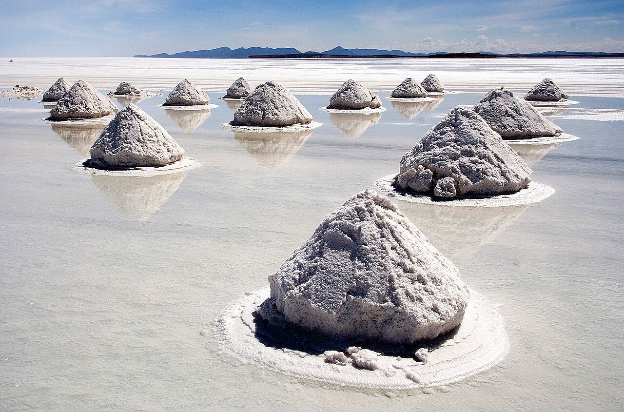
Salt mounds in Salar de Uyuni, Bolivia. Image credit: Luca Galuzzi |
Week 31
 |
|
Interstate 80, the Eastshore Freeway, near Berkeley, California on a Saturday afternoon. Image credit: Minesweeper |
Week 32
 |
|
View of Mount Herschel (3,335 m) from Cape Hallett. It lies in the Admiralty Mountains, Victoria Land, Antarctica. Image credit: Luca Galuzzi |
Week 33
 |
|
Course and watershed of the Nile with topography shading and political boundaries. Image credit: Imagico |
Week 34
 |
|
Aerial view of the transport links passing though Heavitree Gap in Alice Springs, Northern Territory, Australia. Image credit: Codrington, Stephen; Planet Geography, 3rd edition |
Week 35
 |
|
Diagram of a marine sextant. Image credit: Joaquim Alves Gaspar |
Week 36
 |
|
A train crossing the Landwasser Viaduct in Switzerland. Image credit: LosHawlos |
Week 37
 |
|
Synthetic Bismuth crystal, discolorations due to a thin oxide layer. Image credit: Dschwen |
Week 38
 |
|
Kawaguchi town and Mount Fuji from the Kawaguchiko station. Image credit: Andy king50 |
Week 39
 |
|
Map of the Mergui Archipelago in Myanmar. Image credit: Kelisi |
Week 40
 |
|
Mansfield Hollow Lake in Windham County, Connecticut, United States. The U.S. Army Corps of Engineers constructed the dam as a flood control measure. It impounds the waters of the Natchaug River. Image credit: U.S. Army Corps of Engineers |
Week 41
 |
|
The Athabasca River railroad track at the mouth of Brule Lake in Alberta, Canada. Image credit: Anomity |
Week 42
 |
|
Radar animation of Tropical Storm Barry passing through Florida, United States from 07Z to 16Z June 2, 2007. Image credit: NOAA |
Week 43
 |
|
Kaindy Lake in south-east of Kazakhstan. The mountain lakes like this form after the landslide blocks the mountain river. The sticks are dead Picea schrenkiana trees. Image credit: Jonas Satkauskas |
Week 44
 |
|
A barograph of the type used by the Meteorological Service of Canada. Image credit: CambridgeBayWeather |
Week 45
 |
|
The M2 tidal constituent. Amplitude is indicated by color, and the white lines are cotidal differing by 1 hr. The curved arcs around the amphidromic points show the direction of the tides, each indicating a synchronized 6 hour period. Image credit: NASA |
Week 46
 |
|
Illustration of echo sounding. Image credit: US Navy |
Week 47
 |
|
Cross-section of a hydroelectric dam. Image credit: Tennessee Valley Authority |
Week 48
 |
|
A panorama of central Wellington, in New Zealand. It was taken from the summit of Mount Victoria at night. Image credit: Geocachernemesis |
Week 49
 |
|
Llamas and alpacas at Lauca National Park, with Parinacota Volcano in the background. Image credit: mtchm |
Week 50
 |
|
Kommunal'nyjj most, the bridge over the Yenisei River in Krasnoyarsk, Russia, view from the Otdykha island. Image credit: Anatoliy Semyonov |
Week 51
 |
|
The Mattertal, a valley in the Alps, Switzerland. On the western slope a large alluvial fan, deposited by a landslide in the 1990s, can be seen above the village of Randa. Image credit: Woudloper |
Week 52
 |
|
A view on Balsthal (Switzerland) in winter. Image credit: Benjamin Baumgartner |