Nela (river)
| Nela | |
|---|---|
 A natural arch carved by the Nela River in Puentedey, Burgos Province | |
 | |
| Location | |
| Country | Spain |
| Physical characteristics | |
| Source | |
| • location | Montes del Somo, Merindad de Valdeporres |
| • elevation | ca 1,200 m (3,900 ft) |
| Mouth | |
• location | Ebro River |
| Length | 75 km (47 mi)[1] |
| Basin size | 1,081.20 km2 (417.45 sq mi) |
| Discharge | |
| • average | 16.70 m3/s (590 cu ft/s) |
| Basin features | |
| Progression | Ebro→ Balearic Sea |
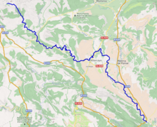
The Nela is a river in northeastern Castile-Leon, Spain, one of the tributaries of the Ebro River. It has a watershed of 1.081,20 km², with a total length of 75 km (47 mi).
The river has its source in the karstic hills of Montes del Somo, near Merindad de Valdeporres. Most of the Nela's water is drawn by the Trasvase Cerneja-Ordunte to supply water to Bilbao, as well as irrigation.[2] There are fishfarms in Busnela and Pedrosa de Valdeporres, as well as a hydroelectric complex in Nofuentes. Finally the Nela flows into the Ebro near Trespaderne.
The amphibian Discoglossus galganoi, the fish Chondrostoma toxostoma and the snail Elona quimperiana are among the most common animal species found in the Nela river's waters.[3]
References
- ^ Datos físicos de las corrientes clasificadas por el C.E.H. Confederación Hidrográfica del Ebro. 1965. p. 151.
- ^ Confederación Hidrográfica del Ebro; Plan Hidrológico
- ^ Minmisterio de Ambiente y Medio Rural y Marino:Biodiversidad:Red Natura 2000:Red Natura
External links
 Media related to Nela River at Wikimedia Commons
- Junta de Castilla y León, Servicio de Espacios Naturales
- Environment - Nature & Biodiversity, Página de la Comisión Europea sobre conservación de la naturaleza y biodiversidad
- Environment - LIFE,Instrumento de financiación para el medio ambiente de la Unión Europea.
43°00′38″N 003°44′24″W / 43.01056°N 3.74000°W / 43.01056; -3.74000