National Register of Historic Places listings in South and Southeast Baltimore
NRHP listings in South and Southeast Baltimore
The locations of the National Register properties and districts listed below (at least for all showing latitude and longitude coordinates below) may be seen in a map by clicking on "Map of all coordinates".[1]
This National Park Service list is complete through NPS recent listings posted April 12, 2024.[2]
Main:List of RHPs in Baltimore
Current listings
| [3] | Name on the Register | Image | Date listed[4] | Location | District[5] | Description |
|---|---|---|---|---|---|---|
| 1 | Bagby Furniture Company Building |  |
October 22, 1998 (#98001263) |
509 S. Exeter St. 39°17′05″N 76°36′00″W / 39.284722°N 76.6°W / 39.284722; -76.6 (Bagby Furniture Company Building) | Southeast | |
| 2 | BALTIMORE (tug) | ,_Baltimore,_Maryland.jpg/1280px-Baltimore_(tugboat),_Baltimore,_Maryland.jpg) |
November 4, 1993 (#93001613) |
1415 Key Highway 39°16′28″N 76°36′01″W / 39.274444°N 76.600278°W / 39.274444; -76.600278 (BALTIMORE (tug)) | South | |
| 3 | Baltimore and Ohio Locust Point Grain Terminal Elevator |  |
December 23, 2004 (#04001379) |
1700 Beason St. 39°16′19″N 76°35′20″W / 39.271944°N 76.588889°W / 39.271944; -76.588889 (Baltimore and Ohio Locust Point Grain Terminal Elevator) | South | |
| 4 | Baltimore and Ohio Transportation Museum and Mount Clare Station | .jpg/1280px-B&O_Mount_Clare_Station_(Baltimore).jpg) |
October 15, 1966 (#66000906) |
Pratt and Poppleton Sts. 39°17′07″N 76°37′57″W / 39.285278°N 76.6325°W / 39.285278; -76.6325 (Baltimore and Ohio Transportation Museum and Mount Clare Station) | South | |
| 5 | BANCROFT (motor vessel) | March 27, 1980 (#80001780) |
Fell's Point 39°16′54″N 76°35′30″W / 39.281667°N 76.591667°W / 39.281667; -76.591667 (BANCROFT (motor vessel)) | Southeast | ||
| 6 | Bankard-Gunther Mansion |  |
August 6, 1980 (#80001781) |
2102 E. Baltimore Street 39°17′31″N 76°35′14″W / 39.291944°N 76.587222°W / 39.291944; -76.587222 (Bankard-Gunther Mansion) | Southeast | |
| 7 | Barre Circle Historic District |  |
January 10, 1983 (#83002926) |
Roughly bounded by Scott St., Ramsey St., Boyd St., and Harbor City Boulevard./S. Fremont St. 39°17′08″N 76°37′43″W / 39.285556°N 76.628611°W / 39.285556; -76.628611 (Barre Circle Historic District) | South | |
| 8 | Building at 239 North Gay Street |  |
October 7, 1994 (#94001202) |
239 N. Gay St. 39°17′38″N 76°36′29″W / 39.293889°N 76.608056°W / 39.293889; -76.608056 (Building at 239 North Gay Street) | Southeast | SW corner of Gay and Front. Iron front, Italianate style. |
| 9 | Butchers Hill Historic District |  |
December 28, 1982 (#82001582) |
Roughly bounded by Patterson Park Ave. and Fayette, Pratt, Chapel, Washington, and Chester Sts. 39°17′29″N 76°35′13″W / 39.291389°N 76.586944°W / 39.291389; -76.586944 (Butchers Hill Historic District) | Southeast | |
| 10 | Canton Historic District |  |
January 29, 1980 (#80001784) |
Eastern Ave. and Waterfront, Conklin, and Chester Sts. 39°16′53″N 76°34′34″W / 39.281389°N 76.576111°W / 39.281389; -76.576111 (Canton Historic District) | Southeast | |
| 11 | Carroll Mansion |  |
May 25, 1973 (#73002182) |
800 E. Lombard St. 39°17′19″N 76°36′17″W / 39.288611°N 76.604722°W / 39.288611; -76.604722 (Carroll Mansion) | Southeast | |
| 12 | Carrollton Viaduct |  |
November 11, 1971 (#71001032) |
Gwynn's Falls near Carroll Park 39°16′31″N 76°39′19″W / 39.275278°N 76.655278°W / 39.275278; -76.655278 (Carrollton Viaduct) | South | |
| 13 | Chizuk Amuno Synagogue |  |
April 19, 1978 (#78003141) |
27–35 Lloyd St. 39°17′24″N 76°36′04″W / 39.29°N 76.601111°W / 39.29; -76.601111 (Chizuk Amuno Synagogue) | Southeast | |
| 14 | Coca-Cola Baltimore Branch Factory |  |
May 4, 2001 (#01000407) |
1215 E. Fort Ave. 39°16′07″N 76°35′53″W / 39.268611°N 76.598056°W / 39.268611; -76.598056 (Coca-Cola Baltimore Branch Factory) | South | |
| 15 | Douglass Place |  |
September 15, 1983 (#83004214) |
516–524 S. Dallas St. 39°17′06″N 76°35′47″W / 39.285°N 76.596389°W / 39.285; -76.596389 (Douglass Place) | Southeast | |
| 16 | Dorguth Memorial United Methodist Church |  |
August 14, 1979 (#79003216) |
Scott and Carroll St. 39°16′56″N 76°37′44″W / 39.282222°N 76.628889°W / 39.282222; -76.628889 (Dorguth Memorial United Methodist Church) | South | |
| 17 | Dundalk Historic District |  |
December 8, 1983 (#83003630) |
Roughly bounded by Liberty Parkway, Dunman, Willow Spring, and Sunship Rds., and Chesapeake and Patapsco Aves. 39°15′35″N 76°31′26″W / 39.259722°N 76.523889°W / 39.259722; -76.523889 (Dundalk Historic District) | Southeast | |
| 18 | Eastern Female High School |  |
September 10, 1971 (#71001035) |
249 Aisquith St. 39°17′40″N 76°36′06″W / 39.294444°N 76.601667°W / 39.294444; -76.601667 (Eastern Female High School) | Southeast | |
| 19 | Equitable Gas Works |  |
December 29, 2003 (#03001322) |
1401 Severn St. 39°16′31″N 76°37′56″W / 39.275278°N 76.632222°W / 39.275278; -76.632222 (Equitable Gas Works) | South | |
| 20 | Federal Hill Historic District |  |
April 17, 1970 (#70000859) |
Bounded by Baltimore Harbor and Hughes, Hanover, and Cross Sts. 39°16′44″N 76°36′36″W / 39.278889°N 76.61°W / 39.278889; -76.61 (Federal Hill Historic District) | South | |
| 21 | Federal Hill South Historic District |  |
December 22, 2003 (#03001331) |
Roughly bounded by Cross St., Olive St., Marshall St., Ostend St., Fort Ave., and Covington St. 39°16′33″N 76°36′39″W / 39.275833°N 76.610833°W / 39.275833; -76.610833 (Federal Hill South Historic District) | South | |
| 22 | Fells Point Historic District |  |
March 28, 1969 (#69000319) |
Bounded on the north by Aliceanna St., on the east by Wolfe St., on the south by Baltimore Harbor, and on the west by Dallas St. 39°16′59″N 76°35′34″W / 39.283056°N 76.592778°W / 39.283056; -76.592778 (Fells Point Historic District) | Southeast | Includes later boundary increase. |
| 23 | Flag House |  |
December 3, 1969 (#69000320) |
844 E. Pratt St. 39°17′15″N 76°36′13″W / 39.2875°N 76.603611°W / 39.2875; -76.603611 (Flag House) | Southeast | |
| 24 | Fort McHenry National Monument and Historic Shrine |  |
October 15, 1966 (#66000907) |
Locust Point, at the eastern end of Fort Ave. 39°15′49″N 76°34′48″W / 39.263611°N 76.58°W / 39.263611; -76.58 (Fort McHenry National Monument and Historic Shrine) | TBD | |
| 25 | Gay Street Historic District |  |
November 21, 2003 (#03001173) |
Bounded by N. Gay, Fallsway, Low and N. Exeter Sts. 39°17′35″N 76°36′26″W / 39.293056°N 76.607222°W / 39.293056; -76.607222 (Gay Street Historic District) | Southeast | |
| 26 | Hendler Creamery |  |
December 20, 2007 (#07001032) |
1100 E. Baltimore St. and 1107 E. Fayette St. 39°17′28″N 76°36′08″W / 39.291111°N 76.602222°W / 39.291111; -76.602222 (Hendler Creamery) | Southeast | |
| 27 | Holy Cross Roman Catholic Church |  |
December 30, 2002 (#02001578) |
106–112 E. West St. 39°16′34″N 76°36′40″W / 39.276111°N 76.611111°W / 39.276111; -76.611111 (Holy Cross Roman Catholic Church) | South | |
| 28 | House at 9 North Front Street |  |
June 14, 1979 (#79003217) |
9 N. Front St. 39°17′26″N 76°36′19″W / 39.290556°N 76.605278°W / 39.290556; -76.605278 (House at 9 North Front Street) | Southeast | |
| 29 | SS JOHN W. BROWN (Liberty Ship) |  |
November 17, 1997 (#97001295) |
Pier 1, Clinton St. 39°16′04″N 76°34′12″W / 39.267778°N 76.57°W / 39.267778; -76.57 (SS JOHN W. BROWN (Liberty Ship)) | Southeast | |
| 30 | Johns Hopkins Hospital Complex |  |
February 24, 1975 (#75002094) |
601 N. Broadway 39°17′50″N 76°35′37″W / 39.297222°N 76.593611°W / 39.297222; -76.593611 (Johns Hopkins Hospital Complex) | Southeast | |
| 31 | Leadenhall Street Baptist Church |  |
March 16, 1979 (#79003218) |
1021–1023 Leadenhall St. 39°16′38″N 76°37′03″W / 39.277222°N 76.6175°W / 39.277222; -76.6175 (Leadenhall Street Baptist Church) | South | |
| 32 | Little Montgomery Street Historic District |  |
April 15, 1982 (#82004748) |
W. Montgomery and Leadenhall Sts. 39°16′48″N 76°37′00″W / 39.28°N 76.616667°W / 39.28; -76.616667 (Little Montgomery Street Historic District) | South | |
| 33 | Lloyd Street Synagogue |  |
April 19, 1978 (#78003142) |
11 Lloyd St. 39°17′26″N 76°36′05″W / 39.290556°N 76.601389°W / 39.290556; -76.601389 (Lloyd Street Synagogue) | Southeast | A part of the Jewish Museum of Maryland. |
| 34 | Locust Point Historic District |  |
December 26, 2012 (#12001084) |
Roughly bounded by Fort Ave., B & O RR., Woodall & Reynolds Sts. 39°16′13″N 76°35′35″W / 39.270404°N 76.593035°W / 39.270404; -76.593035 (Locust Point Historic District) | South | |
| 35 | Loft Historic District North |  |
January 3, 1985 (#85000016) |
Roughly bounded by Paca, Redwood, Eutaw, and Lombard Sts. 39°17′18″N 76°37′19″W / 39.288333°N 76.621944°W / 39.288333; -76.621944 (Loft Historic District North) | South | |
| 36 | Loft Historic District South |  |
January 3, 1985 (#85000017) |
Along the 500 block of W. Pratt St., bounded by Green St. and the 100 block of S. Paca St. 39°17′10″N 76°37′23″W / 39.286111°N 76.623056°W / 39.286111; -76.623056 (Loft Historic District South) | South | |
| 37 | Lord Baltimore Hotel |  |
December 2, 1982 (#82001587) |
20 West Baltimore St. 39°17′23″N 76°36′58″W / 39.289722°N 76.616111°W / 39.289722; -76.616111 (Lord Baltimore Hotel) | South | |
| 38 | Maryland White Lead Works |  |
December 27, 2002 (#02001604) |
921–979 E. Fort Ave. 39°16′14″N 76°36′04″W / 39.270643°N 76.601018°W / 39.270643; -76.601018 (Maryland White Lead Works) | South | |
| 39 | McKim's School |  |
March 30, 1973 (#73002190) |
1120 E. Baltimore St. 39°17′28″N 76°36′04″W / 39.291111°N 76.601111°W / 39.291111; -76.601111 (McKim's School) | Southeast | McKim Community Center |
| 40 | H.L. Mencken House |  |
July 28, 1983 (#83004384) |
1524 Hollins Rd. 39°17′15″N 76°38′29″W / 39.2875°N 76.641389°W / 39.2875; -76.641389 (H.L. Mencken House) | South | |
| 41 | Montgomery Ward Warehouse and Retail Store |  |
September 14, 2000 (#00001085) |
1000 S. Monroe St. 39°16′34″N 76°38′41″W / 39.276111°N 76.644722°W / 39.276111; -76.644722 (Montgomery Ward Warehouse and Retail Store) | South | |
| 42 | Mount Auburn Cemetery |  |
September 7, 2001 (#01000456) |
2614 Annapolis Rd. 39°15′34″N 76°38′23″W / 39.259444°N 76.639722°W / 39.259444; -76.639722 (Mount Auburn Cemetery) | South | |
| 43 | Mount Clare |  |
April 15, 1970 (#70000860) |
Carroll Park 39°16′44″N 76°38′37″W / 39.278889°N 76.643611°W / 39.278889; -76.643611 (Mount Clare) | South | |
| 44 | National Brewing Company |  |
December 30, 2002 (#02001579) |
3601–3901 Dillon St. 39°16′51″N 76°33′53″W / 39.280833°N 76.564722°W / 39.280833; -76.564722 (National Brewing Company) | Southeast | |
| 45 | National Enameling and Stamping Company |  |
December 27, 2002 (#02001583) |
1901 Light St. 39°16′04″N 76°36′38″W / 39.267778°N 76.610556°W / 39.267778; -76.610556 (National Enameling and Stamping Company) | South | |
| 46 | Old Town Friends' Meetinghouse |  |
March 30, 1973 (#73002192) |
1201 E. Fayette St. 39°17′31″N 76°36′04″W / 39.291944°N 76.601111°W / 39.291944; -76.601111 (Old Town Friends' Meetinghouse) | Southeast | |
| 47 | Parker Metal Decoration Company Plant |  |
November 22, 2000 (#00001391) |
333 W. Ostend St. 39°16′31″N 76°37′18″W / 39.275278°N 76.621667°W / 39.275278; -76.621667 (Parker Metal Decoration Company Plant) | South | |
| 48 | Patterson Park-Highlandtown Historic District |  |
December 27, 2002 (#02001623) |
Roughly bounded by Patterson Park Ave., E. Fayette St., and Pulaski Highway, Grundy St., Eastern Ave., Patterson Park 39°17′30″N 76°34′23″W / 39.291667°N 76.573056°W / 39.291667; -76.573056 (Patterson Park-Highlandtown Historic District) | Southeast | |
| 49 | Pigtown Historic District |  |
December 28, 2006 (#06001177) |
Roughly bounded by McHenry St. and Ramsay St., W. Barre, S. Paca, Ostend and Wicomico Sts., Bush and Bayard Sts, and the railroad line 39°16′49″N 76°37′56″W / 39.280278°N 76.632222°W / 39.280278; -76.632222 (Pigtown Historic District) | South | |
| 50 | Polish Home Hall |  |
December 26, 2007 (#07001311) |
4416 Fairhaven Ave. 39°13′31″N 76°35′25″W / 39.225278°N 76.590278°W / 39.225278; -76.590278 (Polish Home Hall) | South | |
| 51 | Poppleton Fire Station |  |
September 8, 1983 (#83002938) |
756–760 W. Baltimore St. 39°17′20″N 76°37′44″W / 39.288889°N 76.628889°W / 39.288889; -76.628889 (Poppleton Fire Station) | South | |
| 52 | Procter and Gamble Baltimore Plant |  |
October 28, 1999 (#99001280) |
1422 Nicholson St. 39°16′30″N 76°35′30″W / 39.275°N 76.591667°W / 39.275; -76.591667 (Procter and Gamble Baltimore Plant) | South | |
| 53 | Public School No. 25 |  |
September 25, 1979 (#79001111) |
S. Bond St. 39°17′06″N 76°35′43″W / 39.285°N 76.595278°W / 39.285; -76.595278 (Public School No. 25) | Southeast | |
| 54 | Ridgely's Delight Historic District |  |
June 6, 1980 (#80001790) |
Roughly bounded by S. Fremont Ave. and W. Pratt, Conway, and Russell Sts. 39°17′08″N 76°37′31″W / 39.285556°N 76.625278°W / 39.285556; -76.625278 (Ridgely's Delight Historic District) | South | |
| 55 | Riverside Historic District |  |
April 30, 2008 (#08000358) |
Bounded by Race St. from the west, south to Winder, east to Webster, north to Heath, east to Boyle and north to Fort, then west to Marshall 39°16′13″N 76°36′33″W / 39.270253°N 76.609264°W / 39.270253; -76.609264 (Riverside Historic District) | South | |
| 56 | Rombro Building |  |
May 26, 2005 (#94001172) |
22–24 S. Howard St. 39°17′18″N 76°37′12″W / 39.288333°N 76.62°W / 39.288333; -76.62 (Rombro Building) | South | |
| 57 | St. Alphonsus' Church, Rectory, Convent and Halle |  |
May 23, 1973 (#73002195) |
112–116, 125–127 W. Saratoga St. 39°17′35″N 76°37′04″W / 39.293056°N 76.617778°W / 39.293056; -76.617778 (St. Alphonsus' Church, Rectory, Convent and Halle) | Southeast | |
| 58 | St. Brigid's School and Convent | December 27, 2016 (#16000909) |
900 S. East Ave. 39°16′56″N 76°34′17″W / 39.282222°N 76.571329°W / 39.282222; -76.571329 (St. Brigid's School and Convent) | |||
| 59 | St. Elizabeth of Hungary |  |
November 4, 1994 (#94001278) |
Junction of E. Baltimore St. and Lakewood Ave. 39°17′33″N 76°34′45″W / 39.2925°N 76.579167°W / 39.2925; -76.579167 (St. Elizabeth of Hungary) | Southeast | |
| 60 | St. Leo's Church |  |
July 28, 1983 (#83002939) |
221 S. Exeter St. 39°17′15″N 76°36′03″W / 39.2875°N 76.600833°W / 39.2875; -76.600833 (St. Leo's Church) | Southeast | |
| 61 | St. Michael's Church Complex |  |
May 17, 1989 (#89000383) |
1900–1920 E. Lombard St. 39°17′26″N 76°35′24″W / 39.290556°N 76.59°W / 39.290556; -76.59 (St. Michael's Church Complex) | Southeast | |
| 62 | St. Paul's Cemetery |  |
June 30, 1988 (#88000746) |
Redwood St. and Martin Luther King Boulevard 39°17′15″N 76°37′41″W / 39.2875°N 76.628056°W / 39.2875; -76.628056 (St. Paul's Cemetery) | South | |
| 63 | St. Peter the Apostle Church and Buildings |  |
October 14, 1976 (#76002184) |
11 and 13 S. Poppleton St. and 848 Hollins St. 39°17′17″N 76°37′56″W / 39.288056°N 76.632222°W / 39.288056; -76.632222 (St. Peter the Apostle Church and Buildings) | South | |
| 64 | St. Vincent De Paul Roman Catholic Church |  |
February 12, 1974 (#74002215) |
120 N. Front St. 39°17′29″N 76°36′24″W / 39.291389°N 76.606667°W / 39.291389; -76.606667 (St. Vincent De Paul Roman Catholic Church) | Southeast | |
| 65 | SAVANNAH (nuclear ship) | 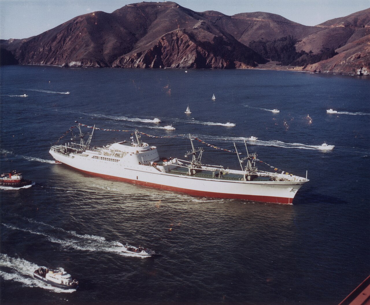 |
November 14, 1982 (#82001518) |
Patapsco River, Port of Baltimore 39°15′31″N 76°33′20″W / 39.258611°N 76.555556°W / 39.258611; -76.555556 (SAVANNAH (nuclear ship)) | South | Previously in York County, Virginia |
| 66 | Shot Tower |  |
October 1, 1969 (#69000373) |
Southeastern corner of Fayette and Front Sts. 39°17′26″N 76°36′20″W / 39.290556°N 76.605556°W / 39.290556; -76.605556 (Shot Tower) | Southeast | Also known as Phoenix Shot Tower. |
| 67 | School No. 27 (Commodore John Rodgers Elementary School) | March 21, 1986 (#86000613) |
2031 E. Fayette St. 39°17′38″N 76°35′16″W / 39.293889°N 76.587778°W / 39.293889; -76.587778 (School No. 27 (Commodore John Rodgers Elementary School)) | Southeast | ||
| 68 | Sonneborn Building |  |
October 29, 1982 (#82001588) |
110 S. Paca St. 39°17′11″N 76°37′21″W / 39.286389°N 76.6225°W / 39.286389; -76.6225 (Sonneborn Building) | South | |
| 69 | South Central Avenue Historic District |  |
November 11, 2001 (#01001213) |
Approximately 8 blocks centering on Central Ave. between Pratt and Fleet Sts. 39°17′12″N 76°35′58″W / 39.286667°N 76.599444°W / 39.286667; -76.599444 (South Central Avenue Historic District) | Southeast | |
| 70 | Southern District Police Station |  |
December 28, 2001 (#01001373) |
28 E. Ostend St. 39°16′30″N 76°36′47″W / 39.275°N 76.613056°W / 39.275; -76.613056 (Southern District Police Station) | South | |
| 71 | Turner-White Casket Co. Building |  |
January 26, 1995 (#94001553) |
509–511 W. Lombard St. 39°17′14″N 76°37′21″W / 39.287222°N 76.6225°W / 39.287222; -76.6225 (Turner-White Casket Co. Building) | South | |
| 72 | U.S. Post Office and Courthouse |  |
March 25, 1977 (#77001530) |
111 N. Calvert St. 39°17′27″N 76°36′44″W / 39.290833°N 76.612222°W / 39.290833; -76.612222 (U.S. Post Office and Courthouse) | South | |
| 73 | Union Bros. Furniture Company | February 7, 2018 (#100001959) |
1120 S Hanover St. 39°16′34″N 76°36′57″W / 39.276117°N 76.615727°W / 39.276117; -76.615727 (Union Bros. Furniture Company) | |||
| 74 | Union Square-Hollins Market Historic District |  |
September 15, 1983 (#83002941) |
Roughly bounded by Fulton, Fayette, Pratt, and Schroeder Sts. 39°17′13″N 76°38′25″W / 39.286944°N 76.640278°W / 39.286944; -76.640278 (Union Square-Hollins Market Historic District) | South | See Union Square and Hollins Market |
| 75 | WHEC-37 |  |
June 7, 1988 (#88001826) |
Pier 6 39°17′09″N 76°36′23″W / 39.285833°N 76.606389°W / 39.285833; -76.606389 (WHEC-37) | South | |
| 76 | Walters Bath No. 2 |  |
June 19, 1979 (#79003220) |
900 Washington Boulevard 39°16′59″N 76°37′52″W / 39.283056°N 76.631111°W / 39.283056; -76.631111 (Walters Bath No. 2) | South | |
| 77 | Wilkens-Robins Building |  |
December 3, 1980 (#80001792) |
308–312 W. Pratt St. 39°17′11″N 76°37′12″W / 39.286389°N 76.62°W / 39.286389; -76.62 (Wilkens-Robins Building) | South |
,_Baltimore,_Maryland.jpg)
.jpg)
See also
References
- ^ The latitude and longitude information provided in this table was derived originally from the National Register Information System, which has been found to be fairly accurate for about 99% of listings. Some locations in this table may have been corrected to current GPS standards.
- ^ National Park Service, United States Department of the Interior, "National Register of Historic Places: Weekly List Actions", retrieved April 12, 2024.
- ^ Numbers represent an alphabetical ordering by significant words. Various colorings, defined here, differentiate National Historic Landmarks and historic districts from other NRHP buildings, structures, sites or objects.
- ^ The eight-digit number below each date is the number assigned to each location in the National Register Information System database, which can be viewed by clicking the number.
- ^ Official Baltimore neighborhoods, defined here
| Topics |  | |
|---|---|---|
| Lists by county | ||
| Lists by city |
| |
| Other lists | ||