Mingan Archipelago National Park Reserve
| Mingan Archipelago National Park Reserve | |
|---|---|
 Niapiskau island, boats at anchor in a bay, limestone monoliths, Gulf of St. Lawrence | |
| Location | Havre-Saint-Pierre / Longue-Pointe-de-Mingan, Minganie Regional County Municipality, Quebec, Canada |
| Nearest city | Sept-Îles, Quebec |
| Coordinates | 50°13′N 63°10′W / 50.217°N 63.167°W / 50.217; -63.167 |
| Area | 151 km2 (58 sq mi) |
| Established | 1984 |
| Visitors | 28,862 (in 2007) |
| Governing body | Parks Canada |
| Official name | Site patrimonial de l'Archipel-de-Mingan |
| Type | Declared heritage site |
| Designated | 1978-11-15 |


Mingan Archipelago National Park Reserve or Mingan Archipelago Heritage Site bathes in the waters of the Gulf of St. Lawrence, in the administrative region of Côte-Nord, in the municipality of Havre-Saint -Pierre, facing Anticosti Island.
Accessible by sea or by air, the reserve protects a thousand islands, islets of rocks, cays and limestone reefs in a mosaic of several ecosystems coexisting on small island surfaces.
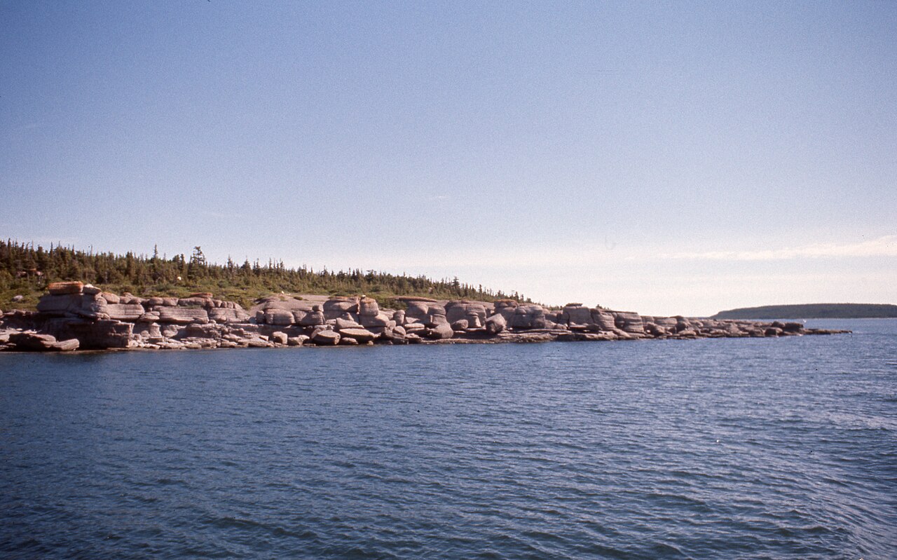
The reserve is home to the largest concentration of erosion monoliths in Canada, important fossil sites, unique ecological environments, alpine arctic flora, including the Mingan thistle, seabirds with the largest concentrations of Arctic terns, Common terns and Common eiders of the St. Lawrence.[1][2][3][4]
Geology
The area of the Mingan islands and part of the mainland to the north of them is underlain by Ordovician sedimentary rocks. The Mingan Islands sequence is composed of two formations — the Romaine below and the Mingan above.
The exposed parts of the Romaine formation consist of dolomite and a little shale. There may be a sandstone at the base. Beds are generally thick and more or less rough in appearance, and in some places they appear kneaded together. The thickness is placed at about 260 feet.
The Mingan formation is composed of conglomerate, sandstone, and shale. These clastic strata are overlain by limestones. These strata contain much fragmentary fossil material and locally are poorly cemented. The larger part of the formation consists of finegrained limestones of which some have semi-lithographic texture. Fossils are locally common and frequently abundant. The exposed thickness is estimated not to exceed 155 feet.[5][6][7][8]
The Mingan Archipelago is a major historical heritage site in Quebec; It is also a mid-Nordic natural environment with some original bio-physical elements: Ordovician limestone, cuestas, morphogenesis associated with the sea, subarctic vegetation cover and varied bird fauna. The construction of Highway 138 in 1976 opened up this fragile and unprotected land. In 1979, the author of The Mingan Archipelago: A Mid-Nordic Space Between Exploitation and Conservation, proposed that this archipelago become a park for conservation and extensive recreation, which was done in 1984.
Flora
With the exception of the covered area just behind the village, the area of Havre Saint-Pierre is mainly covered by large spruce forests and a few laricinin farms. White spruce, Dwarf birch, Rough alder, Quaking aspen can also be seen.
Brothers Marie-Victorin and Rolland Germain F.E.C. explored the region from 1924 to 1928. Their work has raised awareness in the scientific community of the enormous value of the Mingan Archipelago. Since then, other scientists have added to the ecology and phytogeography knowledge of this sector.
The vegetation of the Mingan Islands belongs to the Chibougamau-Natashquan boreal forest region, which is dominated by Black spruce. The high latitude and low altitude, combined with the proximity of the cold currents of Labrador, explain the subarctic vegetation specific to the Minganie.
The entirely calcareous nature of the horizontal stratified rocks, which make up the Anticosti - Minganie, exerts a profound influence on the structure of the flora and on the choice of species.
Remarkable for its richness, the flora includes 350 vascular plants including the presence of two rare taxa: Cirsium foliosum var. Minganense and Cypripedium passerinum var. Minganense. Sixty species are new to the list of Minganie harvests compiled by Marie-Victorin and Rolland-Germain (1969). There were also 150 bryophytes and 152 lichens, 29 of which were additions to the Nouveau Catalogue des lichens, published by Lepage (1972).[9][10] '[11][12]
-
Calypso bulbosa (L.) Oakes, Calypso d’Amérique, Calypso bulbeux. Plant of mossy woods, limestone regions of Quebec (Gaspésie, Minganie, Anticosti), rare elsewhere
-
Nordic flora at our feet on Niapiskau island
-
Frère Marie-Victorin (1885-1944), Mingan archipelago 1928, in hand, the C. minganense (large pale plant, with flower heads gathered in a mass surpassed by the leaves
_(8051428953).jpg/1280px-Fairy_slipper_(Calypso_bulbosa)_(8051428953).jpg)


Fauna
The sea and the land are two worlds intimately related. Strictly speaking, the park's territory consists only of the Mingan islands and not the sea. But how to dissociate the islands from the surrounding blue immensity?
Nearly 200 species of bird can be observed in the field
- Warblers, Terns, Ospreys, Passerines, Razorbills, many waders
- Haliaeetus leucocephalus. -Bald Eagle. -Pygargue à tête blanche
- Somateria mollissima. -Common Eider. -Eider à duvet
- Fratercula arctica. Macareux moine. -Atlantic Puffin
- Bucephala islandica. -Barrow's Goldeneye. -Garrot d'Islande
The large number of habitats here has provided refuge to many different mammals
- Castor canadensis. -Castor du Canada -North American Beaver.
- Lontra canadensis. – Loutre du Canada. -North American river otter
- Ondatra zibethicus L. – Rat musqué. -Muskrat
- Vulpes vulpes L. -Renard roux. -Red fox
- Tamiasciurus hudsonicus. -Écureil roux - American red squirrel
- Lepus americanus. – Snowhoe hare. Lièvre d’Amérique
- Mustela erminea L. – Stoat. -Hermine
- Certain species of bats and a number of small rodents
- Occasionally, Black bears and Moose can be found on certain islands near the coast.
There are three types of seal living around the Mingan Archipelago
- Halichoerus grypus. -Phoque gris. -Grey Seal
- Phoca vitulina. Phoque commun. -Harbour Seal
- Pagophilus groenlandicus. -Phoque du Groenland. -Harp Seal
The waters of and beyond the Mingan archipelago are the hunting grounds of the cetaceans attracted by the huge shoals of plankton and fish that abound in the cold waters of the Gulf of St. Lawrence.
- Lagenorhynchus acutus. -Dauphin à nez blanc. -White-beaked dolphin
- Phocoena phocoena. -Marsouin commun. -Harbor Porpoise
- Balaenoptera acutorostrata. -Petit rorqual. -Minke whale
- Megaptera novaeangliae. -Baleine à bosse. -Humpback whales
- Balaenoptera physalus. - Rorqal commun. -Fin whale
Woodland animals live side by side with those whose habitat is the coast or the cold salty water of the Gulf of St. Lawrence.[13][14][15][16][17]
-
Vulpes vulpes L. -Renard roux. -Red fox
-
Phoca vitulina. -Phoque commun. -Harbour Seal
-
Somateria mollissima. -Common Eider. -Eider à duvet
-
Bucephala islandica. -Barrow's Goldeneye. -Garrot d'Islande
-
Balaenoptera acutorostrata. -Petit rorqual. -Minke whale


.jpg/1280px-Barrows_Goldeneye_6790_(24366489917).jpg)

History
St Lawrence River
The river that the Native Americans called "the way that walks" is feared, and rightly so. On the route of conquerors, explorers, fishermen, hunters, adventurers, and other navigators, it is by entering the waters of the river that the most difficult operation of the journey begins. Shallow channels, estuary reefs, shoals, diagonal currents, fog and narrow, winding channels, winter and ice are the challenges that must be overcome.
In North America, during the French regime (1534-1763), several shipwrecks marked the history of navigation on the St. Lawrence River.
A path of discovery, a route of transport and settlement, an axis of trade and development, a privileged navigable route, little known, perilous and difficult, sailors did not venture on the St. Lawrence at nightfall, neither before the beginning of May nor after the end of November.[18][19]
The Mingan Archipelago
Human occupation of the Mingan Archipelago dates back at least 2000 years. The First Nations, were attracted to the marine resources of this part of the gulf and engaged in molluscs harvesting, salmon fishing and seal hunting, among other activities.
Since the 16th century, the Spaniards, Portuguese and Basques have exploited the marine wealth of the coasts, the gulf and the estuary, the Basques have fished for cod and hunted whales in the Mingan archipelago.
Excavations carried out in 1986 by the Parks Canada, Quebec Region, on Mingan Island Nue and Mingan Harbour Island revealed the remains of a stone oven used by the Basques to melt the blubber of marine mammals. Historical documentation and artifacts suggest that this kiln was built and used by Basques in the seventeenth and eighteenth centuries.[20][21] [2]
Route 138, from Moisie River to Havre-Saint-Pierre

At the beginning of the 20th century, the first routes of what would become Route 138 (formerly Route 15) were laid in the vicinity of Sept-Îles. In 1961, a section was added from the Franquelin region to the tip of the Moisie River, some 20 kilometres east of Sept-Îles.
On the north shore of the Gulf of St. Lawrence, until 1976, there was no continuous route to go further east than the Moisie River. Only bits of paths here and there connect a few coastal villages to each other, Natashquan connects to Aguanish by a dirt road (1959).
Route 138, from Moisie River to Havre-Saint-Pierre, opened in the spring of 1976, from there access to the islands of the Mingan Archipelago by sea.
In 1984, to commemorate the 450th anniversary of Jacques Cartier's arrival in New France, the Commission de toponymie gave this name to the part of Route 138 located east of the Saguenay River, that is, the part that extends from Tadoussac to Havre-Saint-Pierre.[18]' [22]
Photos
- Mingan Archipelago National Park Reserve 1976 - 2003
-
Children playing in the water, bay in an island
-
Monoliths on Niapiskau Island, visitors
-
Monolith on Niapiskau Island, beach, Gulf of St. Lawrence
-
Monoliths on Niapiskau Island
-
Stop at Niapiskau, limestone monoliths, boreal forest, Gulf of St. Lawrence


- Mingan Archipelago National Park Reserve 1976
-
South Quarry Island, monoliths, limestone formations, boreal forest
-
Monolith on Niapiskau, Bay
-
Islands, islets, rocks, cays, reefs
-
La Grande-Île, monoliths, St Lawrence Golf


- Mingan Archipelago National Park Reserve from a seaplane 1976
-
Gulf of St. Lawrence, Mingan Archipelago, islands, monoliths, vegetation of cold shores
-
Ile du Fantôme
-
Gulf of St. Lawrence, Mingan Archipelago, islands, monoliths, cold shoreline vegetation
-
Gulf of St. Lawrence, Mingan Islands
-
Havre-Saint-Pierre, Gulf of St. Lawrence, Mingan Archipelago Islands, mainland


_(8051428953).jpg)
.jpg)
See also
References
- ^ "Mingan Archipelago National Park Reserve". The Canadian Encyclopedia. 2015-01-03. Retrieved 2024-01-12.
Oddly shaped rock pillars sculpted by wind and sea create the unique islandscape of the natural reserve
- ^ a b "Mingan Archipelago National Park Reserve". Government of Canada. 2022-11-19. Retrieved 2024-01-10.
Several animal and plant species present on the islands of the Mingan Archipelago and the surrounding landscape are endangered or at risk
- ^ Michael Melford photograph. "Mingan Archipelago National Park Reserve". Quebec, Canada: National Geographic. Retrieved 2024-01-10.
close to a thousand islands and islets sprinkled along 93 miles from east to west, 24,711 acres
- ^ Zach Baranowski, photograph. "The Mingan Archipelago". St Lawrence golf: Canadian Geographic. Retrieved 2024-01-10.
the shoreline at low tide reveals seemingly endless tide pools full of barnacles, green sea urchins, sea stars and other small invertebrates.
- ^ G. W. Waddington (1950). "Limestone deposits of the Mingan Islands area, Saguenay county" (PDF). Énergie et Ressources naturelles Québec. Geological surveys branch. Retrieved 2024-01-15.
On the west side of Niapisca island there is a good exposure of limestone in a cliff along the south shore of a small bay
- ^ Frederick C. Shaw and Thomas E. Bolton (14 July 2015). "Ordovician trilobites from the Romaine and Mingan formations (Ibexian-late Whiterockian), Mingan Islands, Quebec" (abs). Cambridge University Press. Retrieved 2024-01-15.
Mingan trilobites provide critical information on late Whiterockian trilobite distributions in Laurentia
- ^ D. LAVOIE, G. CHI, P. BRENNAN-ALPERT, A. DESROCHERS, R. BERTRAND (December 2005). "Hydrothermal dolomitization in the Lower Ordovician Romaine Formation" (PDF). Bulletin of Canadian Petroleum Geology. p. 19. Retrieved 2024-01-15.
This study deals with the diagenetic evolution of dolostones of the Romaine Formation, from cores and outcrops on Anticosti and Mingan islands
{{cite web}}: CS1 maint: multiple names: authors list (link) - ^ "Mingan Islands and Adjacent Coast" (PDF). Geology and economie minerals of Canada. 1947. pp. 190 of 370. Retrieved 2014-01-15.
Anticosti Island was visited in 1856 by H.Richardson, who collected many fossils. Geology of Canada, 1863, contains the result of Logan's observations on the island.
- ^ Ministry of Natural Resources and Wildlife, Forêt Québec, Forest Inventory Branch (July 2007). "Guide to the Recognition of Ecological Types: Ecological Region Anticosti Island, Mingan Islands" (PDF) (in French). Quebec Gouvernement. Retrieved 19 January 2024.
an ecological region is a homogeneous unit in relation to the dynamics of vegetation and variables in the physical environment
{{cite web}}: CS1 maint: multiple names: authors list (link) - ^ Marie-Victorin (1885-1944) (2003). "Avant-pays Anticosti-Minganie". florelaurentienne.com (in French). pp. 56 of 920. Retrieved 19 January 2024.
Because of the importance and biological autonomy of this archipelago, we have given it the name of Minganie
{{cite web}}: CS1 maint: numeric names: authors list (link) - ^ "Flora of a thousand faces". Mingan Archipelago National Park Reserve. Gouvernement of Canada. Retrieved 19 January 2024.
The woodlands of the Mingan Islands are made up of Balsam Fir ( Abies balsamea ), Black Spruce ( Picea mariana ) and White Spruce ( Picea glauca ).
- ^ Line Couillard and Pierre Grondin (3 January 2023). "The rare plants of Mingan archipelago" (PDF). Environnement Canada Parks. Retrieved 19 January 2024.
picking of all plants is strictly prohibited in national parks.
- ^ Parks Canada (2022-11-19). "Mingan Archipelago National Park Reserve". Government of Canada. Retrieved 2024-01-16.
Seabirds, Seals, Whales, Land Mammals, occasionally, Black Bears and Moose
- ^ Government of Canada (2020-12-24). "Marine Birds". Parks Canada. Retrieved 2024-01-18.
In order to ensure the reproductive success of these birds, certain islands or sectors of the islands are closed to public during the nesting period
- ^ "Mingan Island Cetacean Study (MICS)". International Whaling Commission. 2024. Retrieved 19 January 2024.
Two to three programmes are offered each year accommodating a total of 25-50 participants in varying locations.
- ^ "Whale Research Expeditions". Mingan Island Cetacean Study. 2024. Retrieved 19 January 2024.
This is a unique educational experience and adventure for nature lovers
- ^ "Mingan Island Cetacean Interpretation Center". Lonely Planet. Retrieved 19 January 2024.
museum gives as many insights into the science of studying whales
- ^ a b The Ages of Exploration. "Jacques Cartier". The Mariners' Museum and ParK. Retrieved 2024-01-13.
Jacques Cartier is credited with discovering and claiming the land now known as Canada for France.
- ^ Morgan Lowrie, The Canadian Press (2016-09-19). "Quebec researchers work to document lost shipwrecks of the St. Lawrence". CTV News. Retrieved 2024-01-16.
To create a list of all the shipwrecks on the St. Lawrence's north shore between Tadoussac and Anticosti Island, a 500-kilometre stretch of shoreline where she believes more than 800 boats went down.
- ^ "The Blue Whale a Fragile Giant" (PDF). Fischeries and Oceans Canada. 2004. Retrieved 2024-01-16.
The dramatic decline in the number of blue whales is mainly due to commercial hunting, which reduced their population by more than 70% during the first half of the 20th century
- ^ Thomas Doniol-Valcroze (October 2001). "Spatial distribution of rorqual whales in the Strait of Jacques Cartier, Gulf of St. Lawrence, Quebec, Canada" (PDF). Department of Natural Resource Sciences McGill University, Montreal. p. 78. Retrieved 2024-01-16.
The study area was located on the North Shore of the Gulf of St. Lawrence, between the Mingan Islands and the northern side of Anticosti Island
- ^ Pierre Frenette (2009). "North Shore, a land of convergence" (PDF) (in French). Les Éditions Histoire Québec. p. 8. Retrieved 14 January 2024.
Logger-farmers swapped axes, harrows, and horses for saws, truck steering wheels, and bulldozer levers
External links
- Mingan Archipelago was represented in the 2011 documentary film series National Parks Project, with its film directed by Catherine Martin and scored by Sebastien Grainger, Jennifer Castle and Dan Werb.
- Number 27: Mingan Archipelago, Quebec, This is where to travel in 2024, according to the New York Times, Liev Kelly, Tuesday 9 January 2024
- 52 Places to Go in 2024, Mingan Archipelago, a national park reserve on the Gulf of St. Lawrence, classify # 27 best Travel Destinations, The New York Times, January 9, 2024
- Official site, North Coast, between nature and excess (French)
- Information from Great Canadian Parks
| Administrative units |
| ||||
|---|---|---|---|---|---|
| Protected areas |
| ||||
| Major river basins | |||||
| Significant lakes | |||||
| Transport infrastructure | |||||
| |||||