List of tripoints
This article needs additional citations for verification. (June 2020) |
This is a list of all three-country tripoints on land or internal waters. Many of the coordinates listed below are only approximate. As of 2020, there are 175 international tripoints. Africa has 61 international tripoints (the highest number of international tripoints), followed by Asia with 51, Europe with 48, South America with 13, and North America with two. Oceania has no international tripoints by virtue of being almost entirely island countries with no land borders.
List
Africa
| Name / description | Country 1 | Country 2 | Country 3 | Coordinates | Region | Image |
|---|---|---|---|---|---|---|
| 23°31′N 12°00′E / 23.517°N 12.000°E / 23.517; 12.000 | Africa - North | |||||
| 30°14′N 9°32′E / 30.233°N 9.533°E / 30.233; 9.533 | Africa - North | |||||
| 25°00′N 4°50′W / 25.000°N 4.833°W / 25.000; -4.833 | Africa - North | |||||
| 19°9′N 4°16′E / 19.150°N 4.267°E / 19.150; 4.267 | Africa - North | |||||
| 27°18′N 8°40′W / 27.300°N 8.667°W / 27.300; -8.667 | Africa - North | |||||
| 27°40′N 8°40′W / 27.667°N 8.667°W / 27.667; -8.667 | Africa - North | |||||
| 4°41′S 13°6′E / 4.683°S 13.100°E / -4.683; 13.100 | Africa - West/Central | |||||
| 10°53′S 23°59′E / 10.883°S 23.983°E / -10.883; 23.983 | Africa - South/East | |||||
| 17°38′S 23°28′E / 17.633°S 23.467°E / -17.633; 23.467 | Africa - South/East | |||||
| 11°54′N 2°24′E / 11.900°N 2.400°E / 11.900; 2.400 | Africa - West/Central | |||||
| 11°0′N 0°55′E / 11.000°N 0.917°E / 11.000; 0.917 | Africa - West/Central | |||||
| 11°42′N 3°36′E / 11.700°N 3.600°E / 11.700; 3.600 | Africa - West/Central | |||||
| Union's End (Nossob River/20°E) | 24°46′S 20°0′E / 24.767°S 20.000°E / -24.767; 20.000 | Africa - South/East | ||||
| near Kasane (four corners) | 17°47′16″S 25°15′24″E / 17.78778°S 25.25667°E / -17.78778; 25.25667 | Africa - South/East | ||||
| Limpopo–Shashe confluence | 22°12′S 29°22′E / 22.200°S 29.367°E / -22.200; 29.367 | Africa - South/East | ||||
| Kasane (Four corners) | 17°47′56″S 25°16′13″E / 17.79889°S 25.27028°E / -17.79889; 25.27028 | Africa - South/East | ||||
| 9°29′N 2°41′W / 9.483°N 2.683°W / 9.483; -2.683 | Africa - West/Central | |||||
| 10°26′N 5°31′W / 10.433°N 5.517°W / 10.433; -5.517 | Africa - West/Central | |||||
| west of Senkase | 11°8′N 0°8′W / 11.133°N 0.133°W / 11.133; -0.133 | Africa - West/Central | ||||
| 15°0′N 0°14′E / 15.000°N 0.233°E / 15.000; 0.233 | Africa - West/Central | |||||
| Ruzizi River | 2°45′S 29°2′E / 2.750°S 29.033°E / -2.750; 29.033 | Africa - South/East | ||||
| Lake Tanganyika | 4°27′S 29°25′E / 4.450°S 29.417°E / -4.450; 29.417 | Africa - South/East | ||||
| 2°24′S 30°34′E / 2.400°S 30.567°E / -2.400; 30.567 | Africa - South/East | |||||
| 7°32′N 15°30′E / 7.533°N 15.500°E / 7.533; 15.500 | Africa - West/Central | |||||
| 2°13′N 16°12′E / 2.217°N 16.200°E / 2.217; 16.200 | Africa - West/Central | |||||
| Lake Tchad | 13°5′N 14°5′E / 13.083°N 14.083°E / 13.083; 14.083 | Africa - West/Central | ||||
| 2°10′N 13°18′E / 2.167°N 13.300°E / 2.167; 13.300 | Africa - West/Central | |||||
| 2°10′N 11°20′E / 2.167°N 11.333°E / 2.167; 11.333 | Africa - West/Central | |||||
| 10°56′N 22°52′E / 10.933°N 22.867°E / 10.933; 22.867 | Africa - West/Central | |||||
| near Betoukoumba | 3°28′N 18°37′E / 3.467°N 18.617°E / 3.467; 18.617 | Africa - West/Central | ||||
| near Nabiapai | 5°1′N 27°27′E / 5.017°N 27.450°E / 5.017; 27.450 | Africa - West/Central | ||||
| 8°38.75′N 24°14.15′E / 8.64583°N 24.23583°E / 8.64583; 24.23583 | Africa - West/Central | |||||
| 23°N 15°E / 23°N 15°E / 23; 15 | Africa - North | |||||
| 19°30′N 24°00′E / 19.5°N 24°E / 19.5; 24 | Africa - North | |||||
| Lake Tchad | 13°42′N 13°38′E / 13.700°N 13.633°E / 13.700; 13.633 | Africa - West/Central | ||||
| 7°34′N 8°28′W / 7.567°N 8.467°W / 7.567; -8.467 | Africa - West/Central | |||||
| 10°10′N 7°58′W / 10.167°N 7.967°W / 10.167; -7.967 | Africa - West/Central | |||||
| 12°28′N 42°24′E / 12.467°N 42.400°E / 12.467; 42.400 | Africa - North | |||||
| 10°59′N 42°58′E / 10.983°N 42.967°E / 10.983; 42.967 | Africa - North | |||||
| Mount Sabyinyo | 1°23′S 29°36′E / 1.383°S 29.600°E / -1.383; 29.600 | Africa - South/East | 
| |||
| Salia Musala, near Oraba | 3°30′N 30°52′E / 3.500°N 30.867°E / 3.500; 30.867 | Africa - South/East | ||||
| Lake Tanganyika | 8°12′S 30°46′E / 8.200°S 30.767°E / -8.200; 30.767 | Africa - South/East | ||||
| near Gabal El Uweinat | 22°N 25°E / 22°N 25°E / 22; 25 | Africa - North | ||||
| 14°15′N 36°34′E / 14.250°N 36.567°E / 14.250; 36.567 | Africa - North | |||||
| Mandera triangle | 3°59′N 41°54′E / 3.983°N 41.900°E / 3.983; 41.900 | Africa - South/East | ||||
| Ilemi Triangle | 5°24′N 35°18′E / 5.4°N 35.3°E / 5.4; 35.3 (disputed) | Africa - South/East | ||||
| 9°30′N 34°6.4′E / 9.500°N 34.1067°E / 9.500; 34.1067 | Africa - North | |||||
| 12°41′N 13°43′W / 12.683°N 13.717°W / 12.683; -13.717 | Africa - West/Central | |||||
| 8°29′N 10°16′W / 8.483°N 10.267°W / 8.483; -10.267 | Africa - West/Central | |||||
| 12°25′N 11°22′W / 12.417°N 11.367°W / 12.417; -11.367 | Africa - West/Central | |||||
| 4°13′N 34°0′E / 4.217°N 34.000°E / 4.217; 34.000 | Africa - South/East | |||||
| Lake Victoria | 1°0′S 33°55′E / 1.000°S 33.917°E / -1.000; 33.917 | Africa - South/East | ||||
| Lake Malawi | 11°34′S 34°58′E / 11.567°S 34.967°E / -11.567; 34.967 (disputed) | Africa - South/East | ||||
| 14°1′S 33°13′E / 14.017°S 33.217°E / -14.017; 33.217 | Africa - South/East | |||||
| 9°24′S 32°58′E / 9.400°S 32.967°E / -9.400; 32.967 | Africa - South/East | |||||
| 14°46′N 12°15′W / 14.767°N 12.250°W / 14.767; -12.250 | Africa - West/Central | |||||
| Mpundweni Beacon | north: 25°57′S 31°58′E / 25.950°S 31.967°E / -25.950; 31.967 | Africa - South/East | ||||
| Abercorn Drift, Maputo River | south: 26°50′S 32°8′E / 26.833°S 32.133°E / -26.833; 32.133 | Africa - South/East | ||||
| Crook's Corner, Pafuri Triangle (Limpopo–Luvuvhu confluence) |
22°25′17″S 31°18′32″E / 22.42139°S 31.30889°E / -22.42139; 31.30889 | Africa - South/East | ||||
| 15°37′S 30°25′E / 15.617°S 30.417°E / -15.617; 30.417 | Africa - South/East | |||||
| 1°4′S 30°29′E / 1.067°S 30.483°E / -1.067; 30.483 | Africa - South/East |
Americas
| Name / description | Country 1 | Country 2 | Country 3 | Coordinates | Region | Image |
|---|---|---|---|---|---|---|
| Zapaleri | 22°48′30″S 67°10′40″W / 22.80833°S 67.17778°W / -22.80833; -67.17778 (Argentina/Bolivia/Chile) | South | 
| |||
| Hito Esmeralda | 22°14′S 62°39′W / 22.233°S 62.650°W / -22.233; -62.650 | South | ||||
| Triple Frontier | 25°35′33″S 54°35′37″W / 25.59250°S 54.59361°W / -25.59250; -54.59361 (Argentina/Brazil/Paraguay at Triple Frontier) | South | ||||
| Brazilian Island | 30°12′S 57°39′W / 30.200°S 57.650°W / -30.200; -57.650 (Argentina/Brazil/Uruguay at Brazilian Island) | South | ||||
| Aguas Turbias | 17°48′47″N 89°8′54″W / 17.81306°N 89.14833°W / 17.81306; -89.14833 | Central | ||||
| 20°10′S 58°10′W / 20.167°S 58.167°W / -20.167; -58.167 | South | |||||
| Assis Brasil / Iñapari / Bolpebra | 10°56′27″S 69°34′1″W / 10.94083°S 69.56694°W / -10.94083; -69.56694 | South | ||||
| Visviri | 17°30′S 69°29′W / 17.500°S 69.483°W / -17.500; -69.483 | South | ||||
| Tres Fronteras | 04°13′00″S 69°56′00″W / 4.21667°S 69.93333°W / -4.21667; -69.93333 | South | ||||
| 1°14′N 66°51′W / 1.233°N 66.850°W / 1.233; -66.850 | South | |||||
| 2°20′N 54°33′W / 2.333°N 54.550°W / 2.333; -54.550 (disputed) | South | |||||
| 1°57′N 56°29′W / 1.950°N 56.483°W / 1.950; -56.483 (disputed) | South | |||||
| Monte Roraima | 5°12′N 60°44′W / 5.200°N 60.733°W / 5.200; -60.733 | South | 
| |||
| 0°7′S 75°15′W / 0.117°S 75.250°W / -0.117; -75.250 | South | |||||
| Cerro de Montecristo | 14°25′18″N 89°21′2″W / 14.42167°N 89.35056°W / 14.42167; -89.35056 | Central |
Asia
| Name / description | Country 1 | Country 2 | Country 3 | Coordinates | Region | Image |
|---|---|---|---|---|---|---|
| Chinese: 5587山峰[1] India claims this portion of Pakistan. | 37°2′N 74°34′E / 37.033°N 74.567°E / 37.033; 74.567 (disputed) | Asia - East/Central |  | |||
| Povalo-Shveikovskogo Peak[2][3] (Chinese: 波万洛什维科夫斯基峰[4]; pinyin: Bōwànluò Shíwéikēfūsījī Fēng) / Kokrash Kol Peak (Kekelaqukaole Peak; Chinese: 克克拉去考勒峰[1]; pinyin: Kèkèlāqùkǎolè Fēng)[5] |
37°14′N 74°53′E / 37.233°N 74.883°E / 37.233; 74.883 | Asia - East/Central | | |||
| west of the Godzareh depression | 29°51′40″N 60°52′58″E / 29.8610°N 60.8828°E / 29.8610; 60.8828 (Afghanistan/Iran/Pakistan) | Asia - West | ||||
| 35°37′N 61°17′E / 35.617°N 61.283°E / 35.617; 61.283 | Asia - West | |||||
| 37°10′N 67°47′E / 37.167°N 67.783°E / 37.167; 67.783 | Asia - East/Central | |||||
| 37°21′N 66°33′E / 37.350°N 66.550°E / 37.350; 66.550 | Asia - East/Central | |||||
| 41°18′07″N 45°00′14″E / 41.30194°N 45.00389°E / 41.30194; 45.00389 | Asia - West | |||||
| east: 38°52′N 46°32′E / 38.867°N 46.533°E / 38.867; 46.533 west: 38°51′N 46°9′E / 38.850°N 46.150°E / 38.850; 46.150 |
Asia - West | |||||
| 39°43′N 44°46′E / 39.717°N 44.767°E / 39.717; 44.767 | Asia - West | |||||
| 41°8′N 43°28′E / 41.133°N 43.467°E / 41.133; 43.467 | Asia - West | |||||
| 41°54′44″N 46°25′33″E / 41.91222°N 46.42583°E / 41.91222; 46.42583 | Asia - West | |||||
| 39°38′N 44°49′E / 39.633°N 44.817°E / 39.633; 44.817 | Asia - West | |||||
| Caspian Sea | 38°42′N 51°24′E / 38.7°N 51.4°E / 38.7; 51.4 (disputed) | Asia - West | ||||
| Caspian Sea | 42°48′N 49°54′E / 42.8°N 49.9°E / 42.8; 49.9 (disputed) | Asia - West | ||||
| Caspian Sea | 41°30′N 51°00′E / 41.5°N 51°E / 41.5; 51 (disputed) | Asia - West | ||||
| Tin Mukh | 21°58′N 92°36′E / 21.967°N 92.600°E / 21.967; 92.600 | Asia - East/Central | ||||
| west: 27°20′N 88°55′E / 27.333°N 88.917°E / 27.333; 88.917 | Asia - East/Central | |||||
| east: 27°46′N 91°39′E / 27.767°N 91.650°E / 27.767; 91.650 (disputed) | Asia - East/Central | |||||
| Chong Bok | 14°20′N 105°13′E / 14.333°N 105.217°E / 14.333; 105.217 | Asia - East/Central | ||||
| 14°41′N 107°33′E / 14.683°N 107.550°E / 14.683; 107.550 | Asia - East/Central | |||||
| UN Buffer Zone (de facto) | east: 35°4′N 33°54′E / 35.067°N 33.900°E / 35.067; 33.900 west: 35°1′N 33°41′E / 35.017°N 33.683°E / 35.017; 33.683 |
Asia - West | ||||
| near Kerem Shalom, Gaza Strip | 31°13′N 34°16′E / 31.217°N 34.267°E / 31.217; 34.267 (disputed) | Asia - West | ||||
| near Diphu Pass mountain pass | 28°13′N 97°21′E / 28.217°N 97.350°E / 28.217; 97.350 (disputed) | Asia - East/Central | ||||
| west: 30°12′N 81°2′E / 30.200°N 81.033°E / 30.200; 81.033 (disputed) | Asia - East/Central | |||||
| Jongsong Peak | east: 27°53′N 88°8′E / 27.883°N 88.133°E / 27.883; 88.133 | Asia - East/Central | ||||
| Siachen Glacier (de facto) Under Pakistan's claim, this tripoint would be at 32°32.2′N 78°23.6′E / 32.5367°N 78.3933°E / 32.5367; 78.3933. Under India's claim there would instead be an Afghanistan-India-Pakistan tripoint at 36°54.7′N 73°40.3′E / 36.9117°N 73.6717°E / 36.9117; 73.6717. |
35°36′N 76°48′E / 35.6°N 76.8°E / 35.6; 76.8 (disputed) | Asia - East/Central | ||||
| 37°9′N 44°47′E / 37.150°N 44.783°E / 37.150; 44.783 | Asia - West | |||||
| 32°9′N 39°12′E / 32.150°N 39.200°E / 32.150; 39.200 | Asia - West | |||||
| Al-Tanf[6] | 33°22′N 38°48′E / 33.367°N 38.800°E / 33.367; 38.800 | Asia - West | ||||
| 29°6′N 46°33′E / 29.100°N 46.550°E / 29.100; 46.550 | Asia - West | |||||
| 37°06′42″N 42°21′48″E / 37.1116°N 42.3633°E / 37.1116; 42.3633 | Asia - West | |||||
| Golan Heights | 32°45′N 35°45′E / 32.750°N 35.750°E / 32.750; 35.750 (disputed) | Asia - West | ||||
| north: 32°23′N 35°33′E / 32.383°N 35.550°E / 32.383; 35.550 south: 31°30′N 35°29′E / 31.500°N 35.483°E / 31.500; 35.483 (disputed) |
Asia - West | |||||
| Golan Heights | 33°20′N 35°46′E / 33.333°N 35.767°E / 33.333; 35.767 (disputed) | Asia - West | ||||
| Khan Tengri | 42°13′N 80°10′E / 42.217°N 80.167°E / 42.217; 80.167 | Asia - East/Central | ||||
| 42°16′N 70°57′E / 42.267°N 70.950°E / 42.267; 70.950 | Asia - East/Central | |||||
| 49°05′59″N 87°18′44″E / 49.0998°N 87.3123°E / 49.0998; 87.3123 | Asia - East/Central | |||||
| 41°19′N 56°0′E / 41.317°N 56.000°E / 41.317; 56.000 | Asia - West | |||||
| near Kurumdy Mountain | 39°28′N 73°36′E / 39.467°N 73.600°E / 39.467; 73.600 | Asia - East/Central | ||||
| near Zar-Tash | 40°14′N 70°59′E / 40.233°N 70.983°E / 40.233; 70.983 | Asia - East/Central | ||||
| 21°34′N 101°9′E / 21.567°N 101.150°E / 21.567; 101.150 | Asia - East/Central | |||||
| Golden Triangle, middle of the Mekong at confluence with Ruak River | 20°21′N 100°5′E / 20.350°N 100.083°E / 20.350; 100.083 | Asia - East/Central | 
| |||
| Shiceng Dashan | 22°24′N 102°9′E / 22.400°N 102.150°E / 22.400; 102.150 | Asia - East/Central | ||||
| Tarbagan-Dakh (Ta'erbagan Dahu, Tarvagan Dakh)[7] | east: 49°50′42.3″N 116°42′46.8″E / 49.845083°N 116.713000°E / 49.845083; 116.713000[7] | Asia - East/Central | ||||
| Tavan-Bogdo-Ula (Mt Kuitun 奎屯山, Tavan Bogd Uul)[8] | west: 49°10′13.5″N 87°48′56.3″E / 49.170417°N 87.815639°E / 49.170417; 87.815639[8] | Asia - East/Central | ||||
| China–North Korea–Russia tripoint in the middle of the Tumen River near Khasan and Tumangang[9] | 42°25′N 130°38′E / 42.417°N 130.633°E / 42.417; 130.633[9] | Asia - East/Central | ||||
| 22°42′N 55°13′E / 22.700°N 55.217°E / 22.700; 55.217 | Asia - West | |||||
| 19°N 52°E / 19°N 52°E / 19; 52 | Asia - West |
Europe
| Name / description | Country 1 | Country 2 | Country 3 | Coordinates | Region | Image |
|---|---|---|---|---|---|---|
| in Lake Prespa | 40°51′06″N 20°59′00″E / 40.85167°N 20.98333°E / 40.85167; 20.98333 (Albania/Greece/Macedonia) | Europe - Central | 
| |||
| 41°52′39″N 20°35′40″E / 41.87750°N 20.59444°E / 41.87750; 20.59444 | Europe - Central | |||||
| Tromedja | 42°33′22″N 20°04′43″E / 42.55611°N 20.07861°E / 42.55611; 20.07861 | Europe - Central | ||||
| Pic de Médécourbe (west) | west: 42°36′07″N 01°26′32″E / 42.60194°N 1.44222°E / 42.60194; 1.44222 (Andorra/France/Spain (West)) | Europe - West | ||||
| east: 42°30′09″N 01°43′28″E / 42.50250°N 1.72444°E / 42.50250; 1.72444 (Andorra/France/Spain (East)) | Europe - West | |||||
| Šumava National Park / near Nová Pec | 48°46′16″N 13°50′22″E / 48.77111°N 13.83944°E / 48.77111; 13.83944 (Austria/Czech Republic/Germany) | Europe - West | 
| |||
| near Hohenau an der March, in the river Morava | 48°36′59″N 16°56′24″E / 48.61639°N 16.94000°E / 48.61639; 16.94000 (Austria/Czech Republic/Slovakia) | Europe - Central | 
| |||
| in Lake Constance | Undecided location, approximately 47°33′N 09°33′E / 47.550°N 9.550°E / 47.550; 9.550 (Austria/Germany/Switzerland at Lake Constance) See Lake Constance#International borders |
Europe - West | 
| |||
| near Rajka, Deutsch Jahrndorf, and Čunovo | 48°00′24″N 17°09′38″E / 48.00667°N 17.16056°E / 48.00667; 17.16056 (Austria/Hungary/Slovakia) | Europe - Central | 
| |||
| near Trdkova | 46°52′9″N 16°6′49″E / 46.86917°N 16.11361°E / 46.86917; 16.11361 | Europe - Central | 
| |||
| Ofen Mountain, near Arnoldstein, or Tromeja | 46°31′22″N 13°42′51″E / 46.52278°N 13.71417°E / 46.52278; 13.71417 (Austria/Italy/Slovenia at Arnoldstein) | Europe - Central | 
| |||
| near Reschen Pass and Piz Lad | 46°51′16″N 10°28′08″E / 46.85444°N 10.46889°E / 46.85444; 10.46889 (Austria/Italy/Switzerland) | Europe - West | ||||
| Feldkirch, in river Rhine | north: 47°16′11″N 09°31′49″E / 47.26972°N 9.53028°E / 47.26972; 9.53028 (Austria/Liechtenstein/Switzerland (North)) | Europe - West | ||||
| Naafkopf | south: 47°3′35″N 09°36′24″E / 47.05972°N 9.60667°E / 47.05972; 9.60667 (Austria/Liechtenstein/Switzerland (South) at Naafkopf) | Europe - West | 
| |||
| Dreiländereck | 55°40′45″N 26°38′0″E / 55.67917°N 26.63333°E / 55.67917; 26.63333 | Europe - North/East | ||||
| Draudzibas kurgans | 56°09′43″N 28°09′26″E / 56.16194°N 28.15722°E / 56.16194; 28.15722 | Europe - North/East | ||||
| in the river Marycha | 53°57′17″N 23°31′00″E / 53.95472°N 23.51667°E / 53.95472; 23.51667 | Europe - North/East | ||||
| in the river Bug, near Tamašoŭka | 51°30′17″N 23°37′29″E / 51.50472°N 23.62472°E / 51.50472; 23.62472 | Europe - North/East | ||||
| Senkivka | 52°06′58″N 31°46′50″E / 52.11611°N 31.78056°E / 52.11611; 31.78056 | Europe - North/East | ||||
| Athus/Rodange | 49°32′46″N 05°49′05″E / 49.54611°N 5.81806°E / 49.54611; 5.81806 | Europe - West | 
| |||
| Ouren, in the river Our | 50°07′47″N 06°08′15″E / 50.12972°N 6.13750°E / 50.12972; 6.13750 | Europe - West | 
| |||
| Vaalserberg | 50°45′16″N 06°01′15″E / 50.75444°N 6.02083°E / 50.75444; 6.02083 | Europe - West | 
| |||
| near Grab | 42°33′44″N 18°27′00″E / 42.56222°N 18.45000°E / 42.56222; 18.45000 | Europe - Central | ||||
| Bijeljina / Jamena, in the river Sava | 44°51′09″N 19°00′38″E / 44.85250°N 19.01056°E / 44.85250; 19.01056 | Europe - Central | ||||
| Zelena Glava | 43°31′N 19°13′E / 43.517°N 19.217°E / 43.517; 19.217 | Europe - Central | ||||
| Tumba Peak (Belasica) | 41°20′37″N 22°56′40″E / 41.34361°N 22.94444°E / 41.34361; 22.94444 | Europe - Central | 
| |||
| On the Maritsa south of Kapitan Andreevo–Kapıkule | 41°42′43″N 26°21′03″E / 41.71194°N 26.35083°E / 41.71194; 26.35083 | Europe - Central | ||||
| Shulep Kamak Peak | 42°19′N 22°22′E / 42.317°N 22.367°E / 42.317; 22.367 | Europe - Central | ||||
| Timok Mouth into river Danube | 44°13′N 22°41′E / 44.217°N 22.683°E / 44.217; 22.683 | Europe - Central | ||||
| 45°55′N 18°49′E / 45.917°N 18.817°E / 45.917; 18.817 | Europe - Central | |||||
| 46°28′N 16°37′E / 46.467°N 16.617°E / 46.467; 16.617 | Europe - Central | |||||
| in the river Neisse near Hrádek nad Nisou / Zittau / Porajów | 50°52′13″N 14°49′22″E / 50.87028°N 14.82278°E / 50.87028; 14.82278 (Czech Republic/Germany/Poland at Hrádek nad Nisou/Zittau/Porajów) | Europe - West | 
| |||
| Hrčava/Čierne | 49°31′03″N 18°50′56″E / 49.51750°N 18.84889°E / 49.51750; 18.84889 | Europe - Central | 
| |||
| Võru / Alūksne / Pskov districts, in the Pededze river | 57°31′05″N 27°21′05″E / 57.51806°N 27.35139°E / 57.51806; 27.35139 | Europe - North/East | ||||
| Muotkavaara / Øvre Pasvik / Nautsi (Treriksrøysa) | 69°3′10″N 28°56′00″E / 69.05278°N 28.93333°E / 69.05278; 28.93333 (Finland/Norway/Russia at Øvre Pasvik) | Europe - North/East | 
| |||
| Treriksröset | 69°03′35″N 20°32′49″E / 69.05972°N 20.54694°E / 69.05972; 20.54694 (Finland/Norway/Sweden at Treriksröset) | Europe - North/East | 
| |||
| in river Moselle near Schengen | 49°28′10″N 06°22′02″E / 49.46944°N 6.36722°E / 49.46944; 6.36722 (France/Germany/Luxembourg at Schengen) | Europe - West | 
| |||
| in the river at Basel | 47°35′23″N 07°35′20″E / 47.58972°N 7.58889°E / 47.58972; 7.58889 (France/Germany/Switzerland at Basel) | Europe - West | .jpg/1280px-Tripoint_Basel_(ws).jpg)
| |||
| Mont Dolent | 45°55′21″N 07°02′39″E / 45.92250°N 7.04417°E / 45.92250; 7.04417 (France/Italy/Switzerland at Mont Dolent) | Europe - West | 
| |||
| Kübekháza / Beba Veche / Majdan | 46°8′N 20°16′E / 46.133°N 20.267°E / 46.133; 20.267 | Europe - Central | 
| |||
| Garbolc | 47°57′15″N 22°53′46″E / 47.95417°N 22.89611°E / 47.95417; 22.89611 (Hungary/Roumania/Ukraine) | Europe - North/East | 
| |||
| 48°24′12″N 22°09′19″E / 48.40333°N 22.15528°E / 48.40333; 22.15528 | Europe - North/East | 
| ||||
| 42°16′N 21°35′E / 42.267°N 21.583°E / 42.267; 21.583 | Europe - Central | |||||
| 42°50′N 20°21′E / 42.833°N 20.350°E / 42.833; 20.350 | Europe - Central | |||||
| at Wiżajny, Suwałki County | 54°21′45″N 22°47′26″E / 54.36250°N 22.79056°E / 54.36250; 22.79056 | Europe - North/East | ||||
| north: 48°15′35″N 26°37′49″E / 48.25972°N 26.63028°E / 48.25972; 26.63028 | Europe - North/East | |||||
| south: 45°28′00″N 28°12′48″E / 45.46667°N 28.21333°E / 45.46667; 28.21333 | Europe - North/East | |||||
| Kremenec | 49°05′14″N 22°33′47″E / 49.08722°N 22.56306°E / 49.08722; 22.56306 | Europe - North/East | 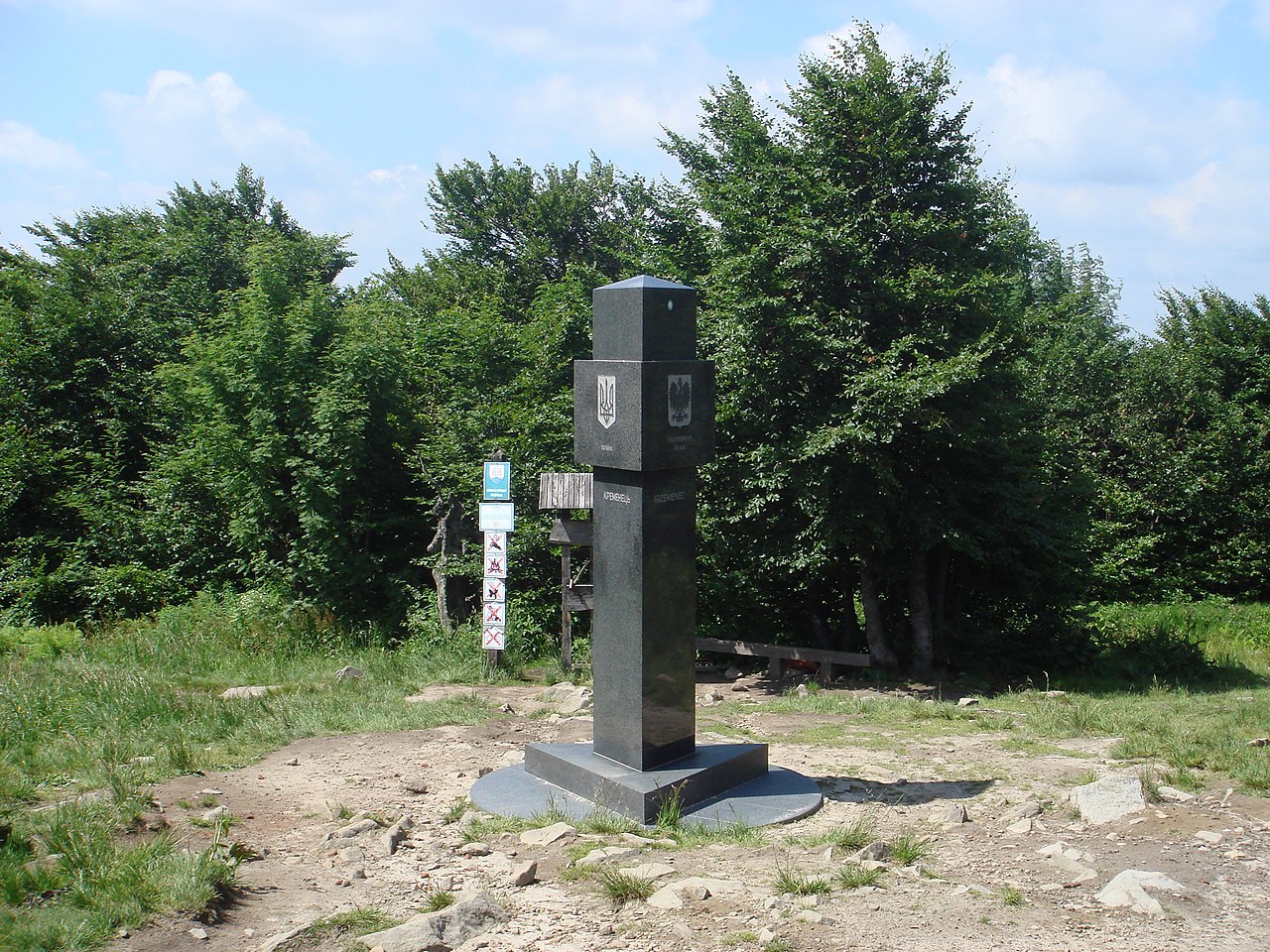
|

.jpg)
See also
Wikimedia Commons has media related to International tripoints.
- List of tripoints of England
- List of tripoints of U.S. states
- Quadripoint
- Tri-cities, for examples of cities within a country's borders.
References
- ^ a b 阿富汗 (in Simplified Chinese). State Ethnic Affairs Commission. 6 July 2004. Archived from the original on 4 December 2008.
中阿边界{...}南起中、巴、阿3国交界处的5587山峰,沿穆斯塔格山脉分水岭北行至克克拉去考勒峰。
- ^ Kamoludin Abdullaev (2018). Historical Dictionary of Tajikistan (3 ed.). Rowman & Littlefield. p. 92. ISBN 9781538102527 – via Google Books.
CHINA-TAJIK BORDER.{...}This mountainous boundary runs along the Sarikol mountain range in eastern Tajikistan, reaching in Pamir the Afghan border at the Povalo-Shveikovskogo peak (5,543 meters above sea level).
- ^ "NJ 43 Su-fu [U.S.S.R., China, Afghanistan, Pakistan, State of Jammu and Kashmir] Series 1301, Edition 5-AMS". Washington, D. C.: Army Map Service. March 1967 – via Perry–Castañeda Library Map Collection.
Pik Povalo-Shveikovskogo
- ^ 中华人民共和国和阿富汗王国边界条约. 22 November 1963 – via Wikisource.
到高程为5698米的克克拉去考勒峰(阿方图称波万洛什维科夫斯基峰)。
- ^ "China Report Political, Sociological and Military Affairs No. 363" (PDF). United States Joint Publications Research Service. 18 November 1982. p. 1. Archived (PDF) from the original on January 11, 2020. Retrieved 11 January 2020 – via Defense Technical Information Center.
If we open up the Atlas of the People's Republic of China we will find that the region of the Pamir, the western extremity of Xinjiang, from the Wuzibieli [Uzbel] Pass1 to the south down to the Kekelaqukaole Peak (which the Soviet Russians call "Pavel Shveikovsky Peak") is designated as a not limited area.
- ^ As known in Syria التنف
- ^ a b Protocol between the Government of the Russian Federation, the Government of Mongolia, and the Government of the People's Republic of China, describing the eastern junction point of the borders of the three states Archived 2018-02-15 at the Wayback Machine (in Russian)
- ^ a b Protocol describing the western junction point of the borders of the PRC, RF, and PRM (in Russian)
- ^ a b Agreement between the Government of the Russian Federation, the Government of the People's Republic of China, and the Government of the People's Democratic Republic of Korea, determining the line of delimitation of the water spaces of the three states on the Tumen River Archived 2015-07-02 at the Wayback Machine (in Russian)
External links
- Borderbase