List of islands of the Dominican Republic

.jpg/1280px-Dominican_Republic_-_panoramio_(22).jpg)


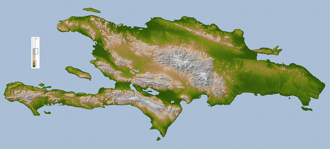
The Dominican Republic, aside from being on the eastern part of Hispaniola (an island which it shares with Haiti), contains many small islands as part of a territory. There were two islands, Cabritos Island, that were in the Isla Cabritos National Park (Parque Nacional Isla Cabritos) on Lake Enriquillo. They were submerged by December 2011.) The other islands are on the Atlantic Ocean or Caribbean Sea (see map link to the right).[1][2]
Island locations
The locations of these islands are listed below:[2]
- Arenas, 19°53′00″N 71°52′00″W / 19.88333°N 71.86667°W / 19.88333; -71.86667 (Arenas)
- Boca Chica Cay, 18°20′19″N 70°49′23″W / 18.33848°N 70.82298°W / 18.33848; -70.82298 (Boca Chica Cay)
- Cayito de Puerto de Luis, 19°10′48″N 69°13′34″W / 19.18001°N 69.22611°W / 19.18001; -69.22611 (Cayito de Puerto de Luis)
- Cayo Agua Dulce, 18°19′01″N 70°51′48″W / 18.31695°N 70.86326°W / 18.31695; -70.86326 (Cayo Agua Dulce)
- Cayo Ahogado, 18°20′00″N 70°50′00″W / 18.33333°N 70.83333°W / 18.33333; -70.83333 (Cayo Ahogado)
- Cayo Arena, 19°09′43″N 69°17′07″W / 19.16205°N 69.2852°W / 19.16205; -69.2852 (Cayo Arena)
- Cayo Arenas, 19°52′00″N 71°15′00″W / 19.86667°N 71.25°W / 19.86667; -71.25 (Cayo Arenas)
- Cayo Arroyo Salado, 19°32′00″N 69°53′00″W / 19.53333°N 69.88333°W / 19.53333; -69.88333 (Cayo Arroyo Salado)
- Cayo La Bocaina, 19°00′40″N 69°11′10″W / 19.01101°N 69.1862°W / 19.01101; -69.1862 (Cayo La Bocaina)
- Cayo Cacata, 19°05′30″N 69°34′09″W / 19.09153°N 69.56914°W / 19.09153; -69.56914 (Cayo Cacata)
- Cayo del Calvario, 19°05′33″N 69°38′10″W / 19.09238°N 69.63623°W / 19.09238; -69.63623 (Cayo del Calvario)
- Cayo Canas, 19°19′36″N 69°23′01″W / 19.32678°N 69.38364°W / 19.32678; -69.38364 (Cayo Canas)
- Cayo El Caney, 18°20′00″N 70°50′00″W / 18.33333°N 70.83333°W / 18.33333; -70.83333 (Cayo El Caney)
- Cayo Chico, 19°11′25″N 69°17′45″W / 19.19033°N 69.29583°W / 19.19033; -69.29583 (Cayo Chico)
- Cayo Los Corozos, 19°10′59″N 69°24′15″W / 19.18307°N 69.40409°W / 19.18307; -69.40409 (Cayo Los Corozos)
- Cayo Culebra, 19°00′54″N 69°10′16″W / 19.01496°N 69.17109°W / 19.01496; -69.17109 (Cayo Culebra)
- Cayo La Isla, 19°51′45″N 70°47′50″W / 19.86244°N 70.79736°W / 19.86244; -70.79736 (Cayo La Isla)
- Cayo La Farola, 19°10′08″N 69°16′13″W / 19.16895°N 69.27022°W / 19.16895; -69.27022 (Cayo La Farola)
- Cayo Garza, 19°11′00″N 69°19′00″W / 19.18333°N 69.31667°W / 19.18333; -69.31667 (Cayo Garza)
- Cayo de la Garza, 19°05′49″N 69°38′29″W / 19.09689°N 69.64131°W / 19.09689; -69.64131 (Cayo de la Garza)
- Cayo de Las Flechas, 19°11′00″N 69°16′32″W / 19.18333°N 69.27568°W / 19.18333; -69.27568 (Cayo de Las Flechas)
- Cayo El Grigrí, 19°39′00″N 70°05′00″W / 19.65°N 70.08333°W / 19.65; -70.08333 (Cayo El Grigrí)
- Cayo Jackson, 19°17′39″N 69°39′48″W / 19.29404°N 69.66337°W / 19.29404; -69.66337 (Cayo Jackson)
- Cayo Limón, 19°19′43″N 69°25′25″W / 19.32874°N 69.42352°W / 19.32874; -69.42352 (Cayo Limón)
- Cayo Levantado (Bacardi Island), 19°17′54″N 69°11′59″W / 19.29823°N 69.19967°W / 19.29823; -69.19967 (Cayo Levantado)
- Cayo Linares, 19°11′48″N 69°20′02″W / 19.19661°N 69.33397°W / 19.19661; -69.33397 (Cayo Linares)
- Cayo Mondesi, 17°44′35″N 71°22′39″W / 17.74295°N 71.37743°W / 17.74295; -71.37743 (Cayo Mondesi)
- Cayo Negro, 19°47′00″N 70°39′00″W / 19.78333°N 70.65°W / 19.78333; -70.65 (Cayo Negro)
- Cayo Paloma, 19°11′32″N 69°19′17″W / 19.19235°N 69.32133°W / 19.19235; -69.32133 (Cayo Paloma)
- Cayo de Pancho Macho, 19°05′27″N 69°38′01″W / 19.09083°N 69.63369°W / 19.09083; -69.63369 (Cayo de Pancho Macho)
- Cayo del Papayo, 17°46′21″N 71°22′40″W / 17.77242°N 71.37779°W / 17.77242; -71.37779 (Cayo del Papayo)
- Cayo Pelú, 19°05′22″N 69°37′55″W / 19.08948°N 69.63185°W / 19.08948; -69.63185 (Cayo Pelú)
- Cayo Puerto Viejo, 18°19′40″N 70°51′05″W / 18.3279°N 70.85127°W / 18.3279; -70.85127 (Cayo Puerto Viejo)
- Cayo Puerto Corral, 18°19′10″N 70°51′38″W / 18.31954°N 70.86046°W / 18.31954; -70.86046 (Cayo Puerto Corral)
- Cayo Puertecito, 18°19′18″N 70°51′30″W / 18.32153°N 70.85829°W / 18.32153; -70.85829 (Cayo Puertecito)
- Cayo Pisaje, 17°50′28″N 71°16′50″W / 17.84105°N 71.28059°W / 17.84105; -71.28059 (Cayo Pisaje)
- Cayo Ratón, 18°09′49″N 68°38′43″W / 18.16355°N 68.64525°W / 18.16355; -68.64525 (Cayo Ratón)
- Cayo Redondo, 19°05′25″N 69°34′03″W / 19.09019°N 69.56745°W / 19.09019; -69.56745 (Cayo Redondo)
- Cayo del Sur, 19°10′00″N 69°16′00″W / 19.16667°N 69.26667°W / 19.16667; -69.26667 (Cayo del Sur)
- Cayo Vigia, 19°11′42″N 69°19′38″W / 19.19498°N 69.32711°W / 19.19498; -69.32711 (Cayo Vigia)
- Cayo de Willy, 19°04′54″N 69°27′55″W / 19.08172°N 69.46535°W / 19.08172; -69.46535 (Cayo de Willy)
- Hispaniola, 19°N 71°W / 19°N 71°W / 19; -71 (Hispaniola))
- Isla Alto Velo, 17°28′33″N 71°38′31″W / 17.4759°N 71.64195°W / 17.4759; -71.64195 (Isla Alto Velo)
- Isla Barbarita
- Isla Beata, 17°35′00″N 71°31′00″W / 17.58333°N 71.51667°W / 17.58333; -71.51667 (Isla Beata)
- El Infiernito, 18°48′15″N 68°33′24″W / 18.80424°N 68.55678°W / 18.80424; -68.55678 (El Infiernito)
- Isla Cabras, 19°53′16″N 71°40′05″W / 19.88787°N 71.66806°W / 19.88787; -71.66806 (Isla Cabras)
- Isla de los Dos Caños, 19°47′27″N 71°45′32″W / 19.79097°N 71.75885°W / 19.79097; -71.75885 (Isla de los Dos Caños)
- Isla Cabritos, 18°29′11″N 71°40′58″W / 18.48636°N 71.68291°W / 18.48636; -71.68291 (Isla Cabritos)
- Isla Catalina, 18°21′28″N 69°00′26″W / 18.3579°N 69.00719°W / 18.3579; -69.00719 (Catalina Island)
- Isla Catalinita, 18°11′46″N 68°38′14″W / 18.19598°N 68.63712°W / 18.19598; -68.63712 (Isla Catalinita)
- Isla Cerro Gordo
- Isla Cuidado, 18°06′33″N 68°34′14″W / 18.10917°N 68.57045°W / 18.10917; -68.57045 (Isla Cuidado)
- Isla Maria, 18°12′42″N 68°43′30″W / 18.21178°N 68.72503°W / 18.21178; -68.72503 (Isla Maria)
- Isla Saona, 18°08′48″N 68°41′16″W / 18.14676°N 68.6877°W / 18.14676; -68.6877 (Isla Saona)
- Isla La Matica, 18°26′36″N 69°36′50″W / 18.44332°N 69.61397°W / 18.44332; -69.61397 (Isla La Matica)
- Islita Island
- Islote El Fraile, 19°53′30″N 71°38′58″W / 19.89163°N 71.64952°W / 19.89163; -71.64952 (Islote El Fraile)
- Islote Manga de Yagua, 19°44′38″N 71°43′49″W / 19.74389°N 71.73038°W / 19.74389; -71.73038 (Islote Manga de Yagua)
- El Jobo, 18°18′31″N 70°52′03″W / 18.30867°N 70.86738°W / 18.30867; -70.86738 (El Jobo)
- Monte Chico, 19°52′00″N 71°46′00″W / 19.86667°N 71.76667°W / 19.86667; -71.76667 (Monte Chico)
- Monte Grande, 19°54′00″N 71°47′00″W / 19.9°N 71.78333°W / 19.9; -71.78333 (Monte Grande)
- Muertos, 19°52′00″N 71°49′00″W / 19.86667°N 71.81667°W / 19.86667; -71.81667 (Muertos)
- La Piedra, 18°26′20″N 69°37′33″W / 18.43894°N 69.62572°W / 18.43894; -69.62572 (La Piedra)
- Piedra de La Ballena, 19°17′52″N 69°11′16″W / 19.29766°N 69.18776°W / 19.29766; -69.18776 (Piedra de La Ballena)
- Piedra Grapin, 19°10′58″N 69°13′15″W / 19.18281°N 69.22083°W / 19.18281; -69.22083 (Piedra Grapin)
- Piedra Negra, 17°29′24″N 71°38′27″W / 17.48998°N 71.6409°W / 17.48998; -71.6409 (Piedra Negra)
- Ratas, 19°53′00″N 71°49′00″W / 19.88333°N 71.81667°W / 19.88333; -71.81667 (Ratas)
- Tercero, 19°54′00″N 71°49′00″W / 19.9°N 71.81667°W / 19.9; -71.81667 (Tercero)
- Tororú, 19°49′39″N 71°47′45″W / 19.82753°N 71.7958°W / 19.82753; -71.7958 (Tororú)
Banks
In addition, two submerged islands, banks, are part of the Dominican Republic:
- Silver Bank, 20°32′30″N 69°42′00″W / 20.54167°N 69.70000°W / 20.54167; -69.70000 (Silver Bank)
- Navidad Bank, 20°01′N 68°51′W / 20.017°N 68.850°W / 20.017; -68.850 (Navidad Bank)
See also
- Geology of the Dominican Republic
- List of national parks of the Dominican Republic
- List of Caribbean islands
References
- ^ Peguero, Adriana (8 December 2011). "Lago Enriquillo amenaza casas de sus alrededores" [Homes around Lake Enriquillo threatened]. Listín Diario (in Spanish). Retrieved 21 December 2011.
... investigador Jorge E. Rodríguez resaltó que han encontrado que el lago Enriquillo ha aumentado en 100%, duplicando su tamaño desde el año 1984, ya que registra una superficie de 350 kilómetros cuadrados, frente a 172 kilómetros cuadrados. [... researcher Jorge E. Rodriguez stressed that he found Lake Enriquillo has increased by 100%, doubling in size since 1984 as it records an area of 350 square kilometers, compared to 172 square kilometers.]
- ^ a b "Islands of the Dominican Republic". GeoNameaccess-date=September 26, 2021.
List of islands of the Americas | ||
|---|---|---|
| ||
|  | |
| Sovereign states |
| |
| ||
.jpg)