Kumhari
Kumhari | |
|---|---|
city | |
 Kumhari Location in Chhattisgarh, India  Kumhari Kumhari (India) | |
| Coordinates: 21°16′N 81°31′E / 21.27°N 81.52°E / 21.27; 81.52 | |
| Country | |
| State | Chhattisgarh |
| District | Durg |
| Government | |
| • Type | Municipal Corporation |
| Area | |
| • Total | 36.9 km2 (14.2 sq mi) |
| Elevation | 285 m (935 ft) |
| Population (2011) | |
| • Total | 35,044 |
| • Density | 950/km2 (2,500/sq mi) |
| Languages | |
| • Official | Hindi, Chhattisgarhi |
| Time zone | UTC+5:30 (IST) |
| Pin | 490042 |
| Vehicle registration | CG-07 |
Kumhari is located in Dhamdha tehsil of Durg district in the Indian state of Chhattisgarh. Kumhari is a Nagar Palika Parishad and situated at Durg district and Raipur district border beside Karun River. It is situated at 21°27'N 81°52' and has an average elevation of 284 meters above the sea level.
The nearest city to Kumhari in Durg district is Bhilai. It is situated at a distance of 5.5 nm west of the Kumhari city. Raipur, the capital city of the state, Chhattisgarh city lies to the east Kumhari's distance from Raipur is about 6.8 nm. The other nearby towns are Jamul and Banbarad situated towards the west of the Kumhari city of Durg. While its distance from the town of Jamul is 6.6 nm, Banbarad is situated 9 nm away from the city of Kumhari. Towards the north of the Kumhari city are the towns of Dharsinwa and Kusmi situated at a distance of 11.7 nm and 15 nm respectively. The city of Mandhar in Raipur district is situated at a distance of .
The nearest airport to this Chhattisgarh city is the one located in [Raipur] Swami Vivekanand airport.
Geography
Kumhari is located at 21°16′N 81°31′E / 21.27°N 81.52°E / 21.27; 81.52.[1] It has an average elevation of 285 metres (935 feet). Area: 36.9 km2 Density: 949.7 inh./km2 [2011] – Change: +1.65%/year [2001 → 2011]
Demographics
Kumhari is divided into 24 wards. Kumhari municipal corporation had controlled Kumhari town and also controlled 5 villages named Kugda, Rampur, Janjgiri, Parsada, Pahanda. As of 2011[update] India census,[2] Kumhari had a population of 45000. Males constitute 52% of the population and females 48%. Kumhari has an average literacy rate of 63%, higher than the national average of 59.5%: male literacy is 71%, and female literacy is 54%. In Kumhari, 16% of the population is under 6 years of age.
Places of interest
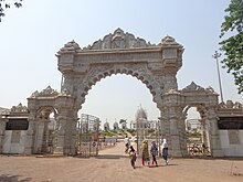
- Kevalya Dham: Jain temple of white marble is on NH 6 and is a place of tourist attraction. Kevalya Dham is a popular Jain tourist pilgrim attraction located in Kumhari town. The temple is also known as Sri Adinath Jain Shwetambar Tirth collection of 26 small and big Jain temples magnificently built with marbles. The temple enshrines the idols of all 24 Tirthankars in small temples with one large temple complex with idol of Rishabhdev. On the corner wall within the shrine carries a detailed description of Sri Shatrunjay Maha Tirtha.
Kaivalydham Jain temple - Mahamaya Temple: There is an old temple of goddess Mahamaya.The beautiful Maa Mahamaya Devi Mandir in Kumhari town is another popular religious attraction. Tourists and devotees from near and far off places visit this temple to offer prayers and seek goddess Mahamaya's blessings.
- Kharun River: Kharun River is a tributary of Shivnath river that empties into Mahanadi river.
- Sai Dham: Sai dham is shridi sai baba temple located at NH 6 Kumhari.
- Durga Maidan Durga Maidan situated in badi colony or ward no 15 has many new things to explore around. There is sahni mandir and during navratri many across charoda and in radius of kumhari come here to play garba and dandiya and many competition are being held in area.

Educational areas
In Kumhari multiple schools and colleges are present which provide quality education in town.
List of schools:
- Govt. Higher Secondary School Kumhari
- Bharti Vidyalaya Kumhari
- Vidya Jyoti English Medium Higher Secondary School Kumhari
- Mansarowar School Janjgiri
- Vishva Vedanta School Kumhari
- Vichakshan Vidyapeeth Near Kevalaya Dham, Kumhari
- Vidya Deep Public School, Kumhari
- Jyoti Hr. Sec. Eng. Med. school, Charoda
List of colleges:
- Sandipany Academy, Achhoti, Kumhari-Ahiwara Road
- Shri Rawatpura Sarkar Pharmacy College
- Shri Rawatpura Sarkar B.Ed college
- ICFAI University
Industries
Kumhari has different types of industries which provides employment to peoples of nearby areas and deals in timber products, steel, iron, coal, liquor and much more.
References
- ^ Falling Rain Genomics, Inc - Kumhari
- ^ "Census of India 2001: Data from the 2001 Census, including cities, villages and towns (Provisional)". Census Commission of India. Archived from the original on 16 June 2004. Retrieved 1 November 2008.
External links
- Durg Government
- Chhattisgarh Government Archived 20 March 2012 at the Wayback Machine
- Latest News of Kumhari