Hoechang County
Hoech'ang County
회창군 | |
|---|---|
| Korean transcription(s) | |
| • Chosŏn'gŭl | 회창군 |
| • Hancha | 檜倉郡 |
| • McCune-Reischauer | Hoech'ang-gun |
| • Revised Romanization | Hoechang-gun |
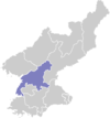
 Map of South Pyongan showing the location of Hoechang | |
| Country | North Korea |
| Province | South P'yŏngan |
| Administrative divisions | 1 ŭp, 4 workers' districts, 17 ri |
| Area | |
| • Total | 681.43 km2 (263.10 sq mi) |
| Population (2008[1]) | |
| • Total | 89,959 |
| • Density | 130/km2 (340/sq mi) |
Hoech'ang County is a kun (county) in South P'yŏngan province, North Korea.
History
Before 1945, most of the territory that now comprises Hoech'ang, was part of neighbouring Sŏngch'ŏn county. In 1952 four townships from Sŏngch'ŏn (Sungin-myŏn, Kuryong-myŏn, Rungjung-myŏn, and Taegok-myŏn) and one from Koksan (Pongmyŏng-myŏn) were split from their counties and merged to form Hoech'ang County.
Administrative divisions
The district is split into 1 ŭp (town), 4 rodongjagu (workers' districts) and 17 ri (villages):
|
|
|
References
- ^ Korean Central Bureau of Statistics: 2008 Population Census Archived 2011-05-14 at the Wayback Machine (Population 2008, published in 2009)
- (in Korean) Detailed map
- (in Korean) County information
External links
