Høyanger
Høyanger Municipality
Høyanger kommune | |
|---|---|
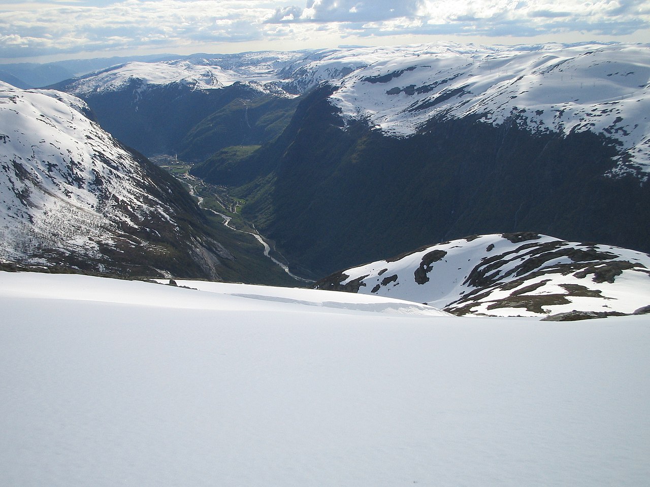 View of the Høyanger valley from the mountain Havren | |
 Vestland within Norway | |
 Høyanger within Vestland | |
| Coordinates: 61°11′17″N 05°53′44″E / 61.18806°N 5.89556°E / 61.18806; 5.89556 | |
| Country | Norway |
| County | Vestland |
| District | Sogn |
| Established | 1 Jan 1964 |
| • Preceded by | Kyrkjebø and Lavik |
| Administrative centre | Høyanger |
| Government | |
| • Mayor (2011) | Petter Sortland (Ap) |
| Area | |
| • Total | 1,000.94 km2 (386.47 sq mi) |
| • Land | 927.62 km2 (358.16 sq mi) |
| • Water | 73.30 km2 (28.30 sq mi) 7.3% |
| • Rank | #115 in Norway |
| Population (2023) | |
| • Total | 3,949 |
| • Rank | #202 in Norway |
| • Density | 4.3/km2 (11/sq mi) |
| • Change (10 years) | |
| Demonym | Høyangring[1] |
| Official language [2] | |
| • Norwegian form | Nynorsk |
| Time zone | UTC+01:00 (CET) |
| • Summer (DST) | UTC+02:00 (CEST) |
| ISO 3166 code | NO-4638[3] |
| Website | Official website |
Data from Statistics Norway | |

Høyanger (Norwegian: [ˈhœ̂ʏɑŋər] ⓘ) is a municipality in Vestland county, Norway. It is located in the traditional district of Sogn. The administrative center is the village of Høyanger. Other villages in Høyanger municipality include Austreim, Bjordal, Kyrkjebø, Lavik, Ortnevik, and Vadheim.
Høyanger is known for having one of the first industrial towns in Norway to use its steep mountains surrounding the town giving excellent conditions for producing hydroelectricity needed for electrolysis. The main product being produced in the village of Høyanger was aluminium.
The 1,001-square-kilometre (386 sq mi) municipality is the 115th largest by area out of the 356 municipalities in Norway. Høyanger is the 202nd most populous municipality in Norway with a population of 3,949. The municipality's population density is 4.3 inhabitants per square kilometre (11/sq mi) and its population has decreased by 6.5% over the previous 10-year period.[4][5]
General information


During the 1960s, there were many municipal mergers across Norway due to the work of the Schei Committee. The municipality of Høyanger was created on 1 January 1964 when the old municipalities of Kyrkjebø and Lavik were merged to form a single municipality.[6]
On 1 January 2020, the Nessane area of neighboring Balestrand Municipality was merged into Høyanger (and the rest of Balestrand was merged into a new, larger Sogndal Municipality).[7] Also on that date, the municipality became part of the newly created Vestland county after Sogn og Fjordane and Hordaland counties were merged.
Name
The municipality is named Høyanger (Old Norse: Høyjangr) after the old name of an arm of the Sognefjorden that is now called the Høyangsfjorden. The first element is derived from the word hey which means "hay". The last element is angr which means "bay" or "inlet". Thus the name is probably referring to the green hillsides along the fjord.[8]
Coat of arms
The coat of arms was granted on 15 May 1987. The official blazon is "Azure, three flames in bend argent" (Norwegian: På blå grunn tre sølv flammer i skrå rekkje). This means the arms have a blue field (background) and the charge is a set of three flames lined up diagonally. The charge has a tincture of argent which means it is commonly colored white, but if it is made out of metal, then silver is used. The flames were chosen as a symbol for the local aluminium industry. Aluminium is melted and purified in the village of Høyanger, due to the cheap hydroelectric energy that is locally available. The colors represent waterpower (blue) and aluminium (silver). The arms were designed by Inge Rotevatn. The municipal flag has the same design as the coat of arms.[9][10][11]
Churches
The Church of Norway has four parishes(sokn) within the municipality of Høyanger. It is part of the Sunnfjord prosti (deanery) in the Diocese of Bjørgvin.
| Parish (sokn) | Church name | Location of the church | Year built |
|---|---|---|---|
| Bjordal og Ortnevik | Bjordal Church | Bjordal | 1906 |
| Ortnevik Church | Ortnevik | 1925 | |
| Høyanger | Høyanger Church | Høyanger | 1960 |
| Kyrkjebø | Kyrkjebø Church | Kyrkjebø | 1869 |
| Vadheim Chapel | Vadheim | 1916 | |
| Lavik | Lavik Church | Lavik | 1865 |
Government
Høyanger Municipality is responsible for primary education (through 10th grade), outpatient health services, senior citizen services, welfare and other social services, zoning, economic development, and municipal roads and utilities. The municipality is governed by a municipal council of directly elected representatives. The mayor is indirectly elected by a vote of the municipal council.[12] The municipality is under the jurisdiction of the Sogn og Fjordane District Court and the Gulating Court of Appeal.
Municipal council
The municipal council (Kommunestyre) of Høyanger is made up of 21 representatives that are elected to four year terms. The tables below show the current and historical composition of the council by political party.
| Party name (in Nynorsk) | Number of representatives | |
|---|---|---|
| Labour Party (Arbeidarpartiet) | 8 | |
| Conservative Party (Høgre) | 2 | |
| Industry and Business Party (Industri‑ og Næringspartiet) | 2 | |
| Red Party (Raudt) | 3 | |
| Centre Party (Senterpartiet) | 5 | |
| Socialist Left Party (Sosialistisk Venstreparti) | 1 | |
| Total number of members: | 21 | |
| Party name (in Nynorsk) | Number of representatives | |
|---|---|---|
| Labour Party (Arbeidarpartiet) | 9 | |
| Conservative Party (Høgre) | 2 | |
| Red Party (Raudt) | 3 | |
| Centre Party (Senterpartiet) | 6 | |
| Socialist Left Party (Sosialistisk Venstreparti) | 1 | |
| Total number of members: | 21 | |
| Party name (in Nynorsk) | Number of representatives | |
|---|---|---|
| Labour Party (Arbeidarpartiet) | 11 | |
| Conservative Party (Høgre) | 2 | |
| Christian Democratic Party (Kristeleg Folkeparti) | 1 | |
| Red Party (Raudt) | 2 | |
| Centre Party (Senterpartiet) | 5 | |
| Total number of members: | 21 | |
| Party name (in Nynorsk) | Number of representatives | |
|---|---|---|
| Labour Party (Arbeidarpartiet) | 10 | |
| Conservative Party (Høgre) | 4 | |
| Christian Democratic Party (Kristeleg Folkeparti) | 1 | |
| Red Party (Raudt) | 2 | |
| Centre Party (Senterpartiet) | 4 | |
| Total number of members: | 21 | |
| Party name (in Nynorsk) | Number of representatives | |
|---|---|---|
| Labour Party (Arbeidarpartiet) | 10 | |
| Conservative Party (Høgre) | 4 | |
| Christian Democratic Party (Kristeleg Folkeparti) | 1 | |
| Red Electoral Alliance (Raud Valallianse) | 2 | |
| Centre Party (Senterpartiet) | 3 | |
| Socialist Left Party (Sosialistisk Venstreparti) | 1 | |
| Total number of members: | 21 | |
| Party name (in Nynorsk) | Number of representatives | |
|---|---|---|
| Labour Party (Arbeidarpartiet) | 11 | |
| Conservative Party (Høgre) | 3 | |
| Coastal Party (Kystpartiet) | 2 | |
| Red Electoral Alliance (Raud Valallianse) | 1 | |
| Centre Party (Senterpartiet) | 3 | |
| Socialist Left Party (Sosialistisk Venstreparti) | 1 | |
| Total number of members: | 21 | |
| Party name (in Nynorsk) | Number of representatives | |
|---|---|---|
| Labour Party (Arbeidarpartiet) | 11 | |
| Progress Party (Framstegspartiet) | 1 | |
| Conservative Party (Høgre) | 8 | |
| Christian Democratic Party (Kristeleg Folkeparti) | 1 | |
| Red Electoral Alliance (Raud Valallianse) | 2 | |
| Centre Party (Senterpartiet) | 4 | |
| Socialist Left Party (Sosialistisk Venstreparti) | 2 | |
| Total number of members: | 29 | |
| Party name (in Nynorsk) | Number of representatives | |
|---|---|---|
| Labour Party (Arbeidarpartiet) | 14 | |
| Progress Party (Framstegspartiet) | 1 | |
| Conservative Party (Høgre) | 4 | |
| Christian Democratic Party (Kristeleg Folkeparti) | 1 | |
| Red Electoral Alliance (Raud Valallianse) | 2 | |
| Centre Party (Senterpartiet) | 5 | |
| Socialist Left Party (Sosialistisk Venstreparti) | 2 | |
| Total number of members: | 29 | |
| Party name (in Nynorsk) | Number of representatives | |
|---|---|---|
| Labour Party (Arbeidarpartiet) | 13 | |
| Conservative Party (Høgre) | 4 | |
| Christian Democratic Party (Kristeleg Folkeparti) | 2 | |
| Red Electoral Alliance (Raud Valallianse) | 1 | |
| Centre Party (Senterpartiet) | 4 | |
| Socialist Left Party (Sosialistisk Venstreparti) | 3 | |
| Common list (Samlingslista) | 2 | |
| Total number of members: | 29 | |
| Party name (in Nynorsk) | Number of representatives | |
|---|---|---|
| Labour Party (Arbeidarpartiet) | 16 | |
| Conservative Party (Høgre) | 4 | |
| Christian Democratic Party (Kristeleg Folkeparti) | 2 | |
| Red Electoral Alliance (Raud Valallianse) | 1 | |
| Centre Party (Senterpartiet) | 2 | |
| Socialist Left Party (Sosialistisk Venstreparti) | 2 | |
| Common list (Samlingslista) | 2 | |
| Total number of members: | 29 | |
| Party name (in Nynorsk) | Number of representatives | |
|---|---|---|
| Labour Party (Arbeidarpartiet) | 17 | |
| Conservative Party (Høgre) | 5 | |
| Christian Democratic Party (Kristeleg Folkeparti) | 2 | |
| Red Electoral Alliance (Raud Valallianse) | 1 | |
| Centre Party (Senterpartiet) | 2 | |
| Socialist Left Party (Sosialistisk Venstreparti) | 3 | |
| Liberal Party (Venstre) | 2 | |
| Common list (Samlingslista) | 3 | |
| Total number of members: | 35 | |
| Party name (in Nynorsk) | Number of representatives | |
|---|---|---|
| Labour Party (Arbeidarpartiet) | 18 | |
| Conservative Party (Høgre) | 5 | |
| Christian Democratic Party (Kristeleg Folkeparti) | 3 | |
| New People's Party (Nye Folkepartiet) | 1 | |
| Centre Party (Senterpartiet) | 3 | |
| Socialist Left Party (Sosialistisk Venstreparti) | 2 | |
| Liberal Party (Venstre) | 2 | |
| Common list (Samlingslista) | 1 | |
| Total number of members: | 35 | |
| Party name (in Nynorsk) | Number of representatives | |
|---|---|---|
| Labour Party (Arbeidarpartiet) | 14 | |
| Christian Democratic Party (Kristeleg Folkeparti) | 3 | |
| Centre Party (Senterpartiet) | 3 | |
| Socialist Left Party (Sosialistisk Venstreparti) | 2 | |
| Joint list of the Conservative Party (Høgre), Liberal Party (Venstre), and New People's Party (Nye Folkepartiet) | 5 | |
| Common list in Høyanger (Samlingslista i Høyanger) | 3 | |
| Non-party list in Høyanger (Upolitisk Liste i Høyanger) | 5 | |
| Total number of members: | 35 | |
| Party name (in Nynorsk) | Number of representatives | |
|---|---|---|
| Labour Party (Arbeidarpartiet) | 15 | |
| Conservative Party (Høgre) | 2 | |
| Christian Democratic Party (Kristeleg Folkeparti) | 3 | |
| Centre Party (Senterpartiet) | 3 | |
| Liberal Party (Venstre) | 3 | |
| Local List(s) (Lokale lister) | 5 | |
| Socialist common list (Venstresosialistiske felleslister) | 3 | |
| Total number of members: | 35 | |
| Party name (in Nynorsk) | Number of representatives | |
|---|---|---|
| Labour Party (Arbeidarpartiet) | 15 | |
| Conservative Party (Høgre) | 2 | |
| Communist Party (Kommunistiske Parti) | 1 | |
| Christian Democratic Party (Kristeleg Folkeparti) | 2 | |
| Centre Party (Senterpartiet) | 3 | |
| Socialist People's Party (Sosialistisk Folkeparti) | 4 | |
| Liberal Party (Venstre) | 5 | |
| Local List(s) (Lokale lister) | 3 | |
| Total number of members: | 35 | |
| Party name (in Nynorsk) | Number of representatives | |
|---|---|---|
| Labour Party (Arbeidarpartiet) | 18 | |
| Communist Party (Kommunistiske Parti) | 3 | |
| Christian Democratic Party (Kristeleg Folkeparti) | 2 | |
| Joint List(s) of Non-Socialist Parties (Borgarlege Felleslister) | 9 | |
| Local List(s) (Lokale lister) | 3 | |
| Total number of members: | 35 | |
Mayors
The mayors (Nynorsk: ordførar) of Høyanger:[26]
Geography
-
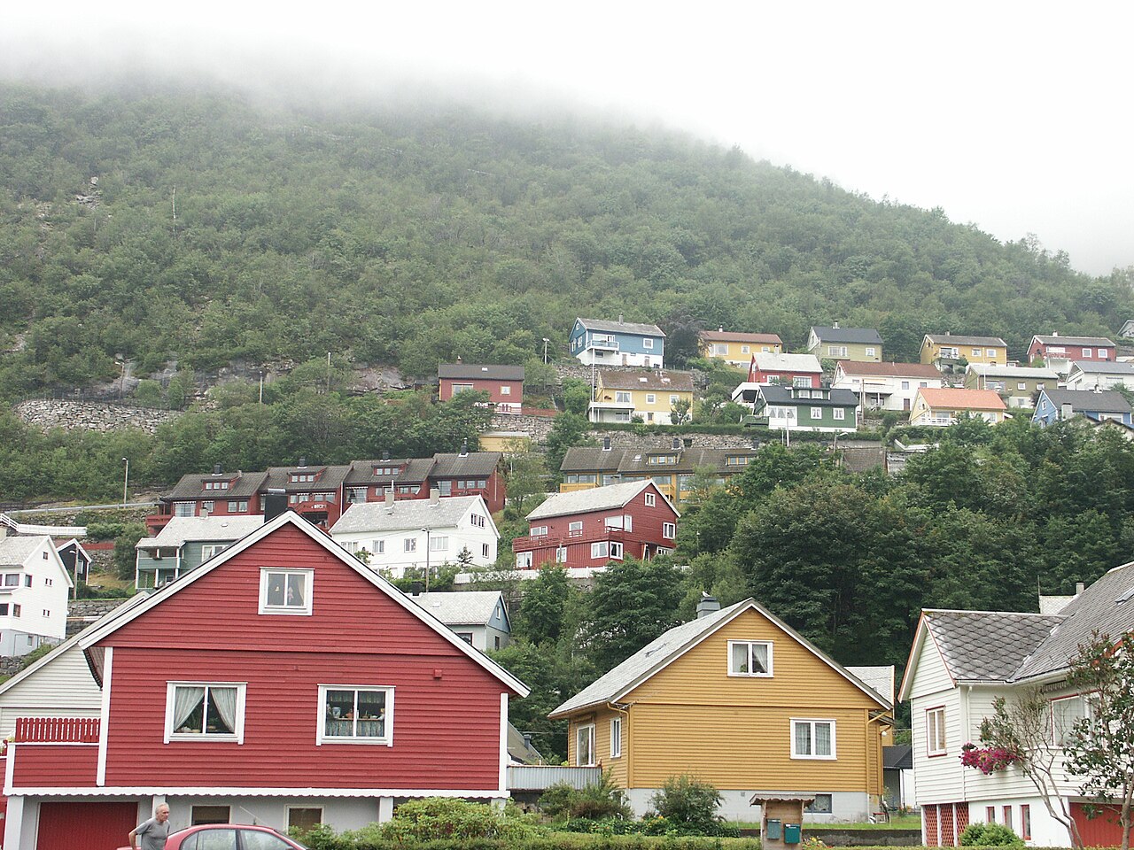
View of the village of Høyanger
-
Construction of the Ikjefjord bridge
-
View of the Fuglsetfjorden
-
View from Ortnevik, looking at the fjord


The Sognefjorden (the largest fjord in Norway) runs through the center of the municipality. Høyanger is bordered to the north by the municipalities of Fjaler and Sunnfjord, to the east by Sogndal and Vik, to the south by Modalen and Masfjorden, and to the west by Gulen and Hyllestad.
Høyanger municipality covers an area of about 910 square kilometres (350 sq mi). Stølsheimen Nature Reserve was created in 1990 in Høyanger. Its 367 square kilometres (142 sq mi) area stretches from high mountaintops through fertile valleys and sweeps over steep meadows down to the fjord. Høyanger is perhaps best known for its mountain farms and lakes. From the village of Ortnevik there are marked footpaths up to Stølsheimen Park and from the village of Bjordal you may drive up the Stordal road to the summit at 730 metres (2,400 ft) above sea level.
Economy
Høyanger is a modern industrial community which has grown in pace with the principal employers being Hydro Aluminium and Høyanger Metallverk. Hydroelectricity has played a major role in the development of the area. In addition to manufacturing aluminium, Høyanger supports a varied range of light industry that is backed by retail and service trades. In the rural areas bordering the fjord, farming is the main source of livelihood.[27] There are currently 115 traditional farms gårds in the municipality. Each traditional farms originally had one owner, but most of them have been divided up and sold off over the years, and so there are more than 115 farms in use today.
Transportation
There are good connections with Oslo and Bergen by bus, as well as air and fast boat services. The nearest airport is in Førde, about 50 kilometres (31 mi) away. The village of Lavik is an important junction for traffic to and from Bergen as it is a ferry port that is part of the European route E39 highway. Høyanger is reached from the neighboring municipality of Balestrand to the east by the Høyangertunnelen which is 7.5 kilometres (4.7 mi) in length. It is part of the Norwegian County Road 55. It is one of the longest tunnels in Europe. Good ferry services across the Sognefjorden link the northern and southern sides of the municipality.[27]
Attractions
In 1986, in Høyanger, Norsk Hydro Aluminium/Høyanger Metallverk opened a museum designed to show what water power has meant both locally and to Norway as a whole. Visitors will get to learn about how the aluminium industry has grown and prospered in the area thanks to the vast energy produced by water.
Near Vadheim is an 18th-century stone bridge called the Ytredal Bridge. It is a popular tourist attraction.
There is also a 600 mm (1 ft 11+5⁄8 in) narrow gauge funicular railway in the area, first opened in 1953.[28]
Notable people


- Johan Austbø (1879 in Ikjefjord – 1945), a teacher, dancer, poet, composer, singer, and proponent for the Nynorsk language
- Einar Liljedahl (1882 in Kyrkjebø – 1955), a Norwegian military officer
- Torfinn Haukås (1931–1993), a novelist
- Per Håland (1919 in Høyanger – 1999), a journalist, newspaper editor, and proponent for the Nynorsk language
- Tell Teigen (1923 in Høyanger - 1958), an acrobat who balanced on stacked chairs atop of masts over 35 metres (115 ft) tall
- Einar Kringlen (born 1931 in Høyanger), a Norwegian physician, psychiatrist, and academic
- Noralv Teigen (1932 in Høyanger – 2017), an actor, theatre instructor, and theatre director[29]
- Einar Førde (1943 in Høyanger – 2004), a journalist, politician, and director-general of the Norwegian Broadcasting Corporation (NRK) from 1989 to 2001
- Marit Tusvik (born 1951 in Høyanger), a Norwegian author, poet, and playwright
- Even Hovland (born 1989 in Vadheim), a professional footballer with almost 300 club caps
- Vegar Gjermundstad (born 1990 in Vadheim), a Norwegian football defender with over 200 club caps
References
- ^ "Navn på steder og personer: Innbyggjarnamn" (in Norwegian). Språkrådet.
- ^ "Forskrift om målvedtak i kommunar og fylkeskommunar" (in Norwegian). Lovdata.no.
- ^ Bolstad, Erik; Thorsnæs, Geir, eds. (26 January 2023). "Kommunenummer". Store norske leksikon (in Norwegian). Kunnskapsforlaget.
- ^ Statistisk sentralbyrå. "Table: 06913: Population 1 January and population changes during the calendar year (M)" (in Norwegian).
- ^ Statistisk sentralbyrå. "09280: Area of land and fresh water (km²) (M)" (in Norwegian).
- ^ Jukvam, Dag (1999). Historisk oversikt over endringer i kommune- og fylkesinndelingen (PDF) (in Norwegian). Statistisk sentralbyrå. ISBN 9788253746845.
- ^ Kommunal- og moderniseringsdepartementet (10 December 2018). "Vedtak om grensejustering mellom kommunane Balestrand og Høyanger". Retrieved 1 December 2019.
- ^ Rygh, Oluf (1919). Norske gaardnavne: Nordre Bergenhus amt (in Norwegian) (12 ed.). Kristiania, Norge: W. C. Fabritius & sønners bogtrikkeri. p. 180.
- ^ "Civic heraldry of Norway - Norske Kommunevåpen". Heraldry of the World. 7 April 2023. Retrieved 15 May 2023.
- ^ "Hoyanger, Sogn og Fjordane (Norway)". Flags of the World. Retrieved 15 May 2023.
- ^ "Godkjenning av våpen og flagg". Lovdata.no (in Norwegian). Norges kommunal- og arbeidsdepartementet. 15 May 1987. Retrieved 15 May 2023.
- ^ Hansen, Tore; Vabo, Signy Irene, eds. (20 September 2022). "kommunestyre". Store norske leksikon (in Norwegian). Kunnskapsforlaget. Retrieved 14 October 2022.
- ^ "Kommunestyrevalg 2023 - Vestland". Valgdirektoratet. Retrieved 21 January 2024.
- ^ "Kommunestyrevalg 2019 – Vestland". Valgdirektoratet. Retrieved 29 October 2019.
- ^ a b c d "Table: 04813: Members of the local councils, by party/electoral list at the Municipal Council election (M)" (in Norwegian). Statistics Norway.
- ^ "Kommunestyrevalg 2011 – Sogn og Fjordane". Valgdirektoratet. Retrieved 29 October 2019.
- ^ "Kommunestyrevalget 1995" (PDF) (in Norwegian). Oslo-Kongsvinger: Statistisk sentralbyrå. 1996. Retrieved 18 February 2020.
- ^ "Kommunestyrevalget 1991" (PDF) (in Norwegian). Oslo-Kongsvinger: Statistisk sentralbyrå. 1993. Retrieved 18 February 2020.
- ^ "Kommunestyrevalget 1987" (PDF) (in Norwegian). Oslo-Kongsvinger: Statistisk sentralbyrå. 1988. Retrieved 18 February 2020.
- ^ "Kommunestyrevalget 1983" (PDF) (in Norwegian). Oslo-Kongsvinger: Statistisk sentralbyrå. 1984. Retrieved 18 February 2020.
- ^ "Kommunestyrevalget 1979" (PDF) (in Norwegian). Oslo: Statistisk sentralbyrå. 1979. Retrieved 18 February 2020.
- ^ "Kommunevalgene 1975" (PDF) (in Norwegian). Oslo: Statistisk sentralbyrå. 1977. Retrieved 1 May 2020.
- ^ "Kommunevalgene 1972" (PDF) (in Norwegian). Oslo: Statistisk sentralbyrå. 1973. Retrieved 1 May 2020.
- ^ "Kommunevalgene 1967" (PDF) (in Norwegian). Oslo: Statistisk sentralbyrå. 1967. Retrieved 1 May 2020.
- ^ "Kommunevalgene 1963" (PDF) (in Norwegian). Oslo: Statistisk sentralbyrå. 1964. Retrieved 1 May 2020.
- ^ "Ordførarar i Høyanger kommune". NRK Fylkesleksikon (in Norwegian Nynorsk). Retrieved 15 May 2023.
- ^ a b Høyanger Kommune (2008). "Høyanger is a modern industrial community". Retrieved 11 June 2008.[permanent dead link]
- ^ Funiculars.net - Høyanger
- ^ Noralv Teigen at IMDb. Retrieved 29 October 2020.
External links
- Municipal fact sheet from Statistics Norway (in Norwegian)
- Official website: Høyanger Kommune (in Norwegian)
| |||||||||||||
 | Towns and cities | ||||||||||||
| Municipalities |
| ||||||||||||
| |||||||||||||