Fort Providence
Fort Providence
Zhahti Koe, Zhahti Kue | |
|---|---|
 Fort Providence from the Mackenzie River | |
 Fort Providence  Fort Providence | |
| Coordinates: 61°21′17″N 117°39′36″W / 61.35472°N 117.66000°W / 61.35472; -117.66000 | |
| Country | Canada |
| Territory | Northwest Territories |
| Region | South Slave Region |
| Constituency | Deh Cho |
| Census division | Region 4 |
| Hamlet | 1 January 1987 |
| Government | |
| • Mayor | Sam Gargan |
| • Senior Administrative Officer | Susan Christie |
| • MP | Michael McLeod |
| Area [1] | |
| • Land | 255.05 km2 (98.48 sq mi) |
| Elevation | 160 m (520 ft) |
| Population (2011)[1] | |
| • Total | 695 |
| • Density | 2.7/km2 (7/sq mi) |
| Time zone | UTC−07:00 (MST) |
| • Summer (DST) | UTC−06:00 (MDT) |
| Canadian Postal code | X0E 0L0 |
| Area code | 867 |
| Telephone exchange | 699 |
| - Living cost | 137.5A |
| - Food price index | 134.7B |
| Sources: Department of Municipal and Community Affairs,[2] Prince of Wales Northern Heritage Centre,[3] Canada Flight Supplement[4] ^A 2013 figure based on Edmonton = 100[5] ^B 2015 figure based on Yellowknife = 100[5] | |
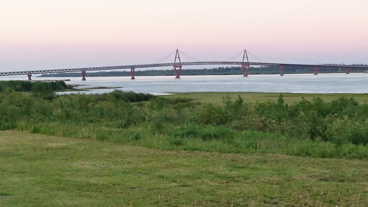
Fort Providence (Slave: Zhahti Koe, Zhahti Kue, lit. 'mission house'[pronunciation?]) is a hamlet in the South Slave Region of the Northwest Territories, Canada. Located west of Great Slave Lake, it has all-weather road connections by way of the Yellowknife Highway (Great Slave Highway) branch off the Mackenzie Highway, and the Deh Cho Bridge opened November 30, 2012, near Fort Providence over the Mackenzie. The bridge replaced the ice bridge and ferry, enabling year-round crossing of the river.
Fort Providence hosts the annual Mackenzie Days celebrations in August each year.
History
Fort Providence was founded in the 1860s as a Catholic mission site. By 1868, the Hudson's Bay Company, which previously has a trading post at Big Island at the source of the MacKenzie River, moved the post to the location of the mission site. From that moment, the settlement was known as Fort Providence. In 1867, the Grey Nuns opened a boarding school and an orphanage in the settlement. Instruction languages were English and French, and most of the nuns originated from Quebec.[6]
Demographics
|
| ||||||||||||||||||||||||||||||||||||||||||||||||||||||||||||||||||||||||
| Sources: NWT Bureau of Statistics (2001 - 2017)[15] | |||||||||||||||||||||||||||||||||||||||||||||||||||||||||||||||||||||||||
In the 2021 Census of Population conducted by Statistics Canada, Fort Providence had a population of 618 living in 256 of its 292 total private dwellings, a change of -11.1% from its 2016 population of 695. With a land area of 255.49 km2 (98.65 sq mi), it had a population density of 2.4/km2 (6.3/sq mi) in 2021.[14]
In 2016, the majority of its population, 620, were Indigenous people, made up of 590 First Nations, Dene people, and 30 Métis.[1]
First Nations
The Dene of the community are represented by the Deh Gáh Got'ı̨ę First Nation[16] and the Métis by Fort Providence Métis Nation.[17] Both groups belong to the Dehcho First Nations.[18]
Gallery

-
Fort Providence Health Centre
-
Our Lady of Providence RC Mission in Fort Providence
-
Providence Mission Indian Residential School showing new Roman Catholic Mission on the left, circa 1930
-
Fort Providence Deh Cho Land Use Planning Committee & Dene Fur Clouds sign
-
The Merv Hardie ferry in use before the bridge was opened.
-
The Deh Cho Bridge


.jpg/1280px-View_of_Providence_Mission_Indian_Residential_School_showing_new_Roman_Catholic_Mission_on_the_left,_Fort_Providence,_NWT_(13929395680).jpg)


.jpg)
Climate
Fort Providence has a continental subarctic climate (Dfc) typical of the Northwest Territories' populated areas. It is marked by a long cold winter season and short, warm summers, that in many ways are warmer than expected for an area so far north. Transition seasons are extremely short, with temperatures rising and falling quickly in respective seasons.
| Climate data for Fort Providence, 1981–2010 normals, extremes 1943–present | |||||||||||||
|---|---|---|---|---|---|---|---|---|---|---|---|---|---|
| Month | Jan | Feb | Mar | Apr | May | Jun | Jul | Aug | Sep | Oct | Nov | Dec | Year |
| Record high °C (°F) | 7.0 (44.6) |
9.9 (49.8) |
16.5 (61.7) |
24.0 (75.2) |
31.3 (88.3) |
34.4 (93.9) |
35.2 (95.4) |
36.1 (97.0) |
30.3 (86.5) |
24.4 (75.9) |
12.8 (55.0) |
11.8 (53.2) |
36.1 (97.0) |
| Mean daily maximum °C (°F) | −18.9 (−2.0) |
−12.9 (8.8) |
−6.2 (20.8) |
5.8 (42.4) |
12.8 (55.0) |
20.9 (69.6) |
23.5 (74.3) |
20.4 (68.7) |
13.4 (56.1) |
3.2 (37.8) |
−7.7 (18.1) |
−15.1 (4.8) |
3.3 (37.9) |
| Daily mean °C (°F) | −23.4 (−10.1) |
−18.7 (−1.7) |
−13.6 (7.5) |
−1.0 (30.2) |
6.3 (43.3) |
13.5 (56.3) |
16.9 (62.4) |
14.0 (57.2) |
7.9 (46.2) |
−0.8 (30.6) |
−11.5 (11.3) |
−19.2 (−2.6) |
−2.5 (27.5) |
| Mean daily minimum °C (°F) | −27.8 (−18.0) |
−24.3 (−11.7) |
−20.9 (−5.6) |
−7.7 (18.1) |
−0.3 (31.5) |
6.0 (42.8) |
10.1 (50.2) |
7.6 (45.7) |
2.4 (36.3) |
−4.8 (23.4) |
−15.2 (4.6) |
−23.1 (−9.6) |
−8.2 (17.2) |
| Record low °C (°F) | −49.4 (−56.9) |
−50.0 (−58.0) |
−45.0 (−49.0) |
−41.1 (−42.0) |
−22.2 (−8.0) |
−5.6 (21.9) |
−2.0 (28.4) |
−2.8 (27.0) |
−14.4 (6.1) |
−27.3 (−17.1) |
−44.4 (−47.9) |
−49.4 (−56.9) |
−50.0 (−58.0) |
| Average relative humidity (%) | 74.9 | 67.6 | 53.1 | 44.4 | 41.8 | 41.7 | 47.1 | 51.4 | 57.6 | 71.3 | 84.0 | 80.2 | 59.6 |
| Source: Environment Canada[19][20] | |||||||||||||
See also
- List of municipalities in the Northwest Territories
- Fort Providence Airport
- Fort Providence Water Aerodrome
References
- ^ a b c d "Population and dwelling counts, for Canada, provinces and territories, and census subdivisions (municipalities), 2016 and 2011 censuses – 100% data (Northwest Territories)". Statistics Canada. February 8, 2017. Retrieved February 1, 2022.
- ^ "NWT Communities - Fort Providence". Government of the Northwest Territories: Department of Municipal and Community Affairs. Retrieved January 13, 2014.
- ^ "Northwest Territories Official Community Names and Pronunciation Guide". Prince of Wales Northern Heritage Centre. Yellowknife: Education, Culture and Employment, Government of the Northwest Territories. Archived from the original on January 13, 2016. Retrieved January 13, 2016.
- ^ Canada Flight Supplement. Effective 0901Z 16 July 2020 to 0901Z 10 September 2020.
- ^ a b "Fort Providence - Statistical Profile (2001-2012)" (PDF). NWT Bureau of Statistics. Archived (PDF) from the original on August 29, 2018.
- ^ Piper, Liza. "Brief History of Fort Providence" (PDF). University of Alberta.
- ^ "1981 Census of Canada: Census subdivisions in decreasing population order" (PDF). Statistics Canada. May 1992. Retrieved February 1, 2021.
- ^ "1986 Census: Population - Census Divisions and Census Subdivisions" (PDF). Statistics Canada. September 1987. Retrieved February 1, 2022.
- ^ "91 Census: Census Divisions and Census Subdivisions - Population and Dwelling Counts" (PDF). Statistics Canada. April 1992. Retrieved February 1, 2022.
- ^ "96 Census: A National Overview - Population and Dwelling Counts" (PDF). Statistics Canada. April 1997. Retrieved February 1, 2022.
- ^ "Population and Dwelling Counts, for Canada, Provinces and Territories, and Census Subdivisions (Municipalities), 2001 and 1996 Censuses - 100% Data (Northwest Territories)". Statistics Canada. August 15, 2012. Retrieved February 1, 2022.
- ^ "Population and dwelling counts, for Canada, provinces and territories, and census subdivisions (municipalities), 2006 and 2001 censuses - 100% data (Northwest Territories)". Statistics Canada. August 20, 2021. Retrieved February 1, 2022.
- ^ "Population and dwelling counts, for Canada, provinces and territories, and census subdivisions (municipalities), 2011 and 2006 censuses (Northwest Territories)". Statistics Canada. July 25, 2021. Retrieved February 1, 2022.
- ^ a b "Population and dwelling counts: Canada, provinces and territories, and census subdivisions (municipalities), Northwest Territories". Statistics Canada. February 9, 2022. Retrieved February 18, 2022.
- ^ Population Estimates By Community from the GNWT
- ^ "Deh Gah Gotie Dene Band". Archived from the original on August 9, 2011. Retrieved June 16, 2011.
- ^ "Fort Providence Métis". Archived from the original on August 9, 2011. Retrieved June 16, 2011.
- ^ "Dehcho First Nations". Archived from the original on July 25, 2011. Retrieved June 16, 2011.
- ^ "Fort Providence". Canadian Climate Normals 1981–2010. Environment Canada. Climate ID: 2201799. Archived from the original (CSV (3069 KB)) on March 13, 2020. Retrieved January 9, 2014.
- ^ "Fort Providence". Canadian Climate Data. Environment Canada. Retrieved August 9, 2016.