File:German Empire states map.svg
Size of this PNG preview of this SVG file: 496 × 600 pixels. Other resolutions: 198 × 240 pixels | 397 × 480 pixels | 635 × 768 pixels | 847 × 1,024 pixels | 1,694 × 2,048 pixels | 1,042 × 1,260 pixels.
Original file (SVG file, nominally 1,042 × 1,260 pixels, file size: 2.31 MB)
| This is a file from the Wikimedia Commons. Information from its description page there is shown below. Commons is a freely licensed media file repository. You can help. |
Summary
| Description |
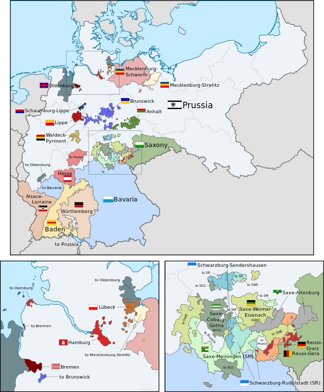
English: A map of the states of the German Empire, showing their location, flags and names in English. |
| Date | |
| Source |
This file was derived from: German Empire blank map.svg: This vector image includes elements that have been taken or adapted from this file: Flagge Herzogtum Anhalt.svg (by David Liuzzo).This vector image includes elements that have been taken or adapted from this file: Flagge Großherzogtum Baden (1891–1918).svg (by David Liuzzo).This vector image includes elements that have been taken or adapted from this file: Flag of Bavaria (striped).svg (by Boris23).This vector image includes elements that have been taken or adapted from this file: Flag of Bremen.svg (by Madden).This vector image includes elements that have been taken or adapted from this file: Flagge Herzogtum Braunschweig.svg (by David Liuzzo).This vector image includes elements that have been taken or adapted from this file: Flagge Großherzogtum Hessen ohne Wappen.svg (by David Liuzzo).This vector image includes elements that have been taken or adapted from this file: Flagge Fürstentum Lippe.svg (by David Liuzzo).This vector image includes elements that have been taken or adapted from this file: Flagge Fürstentum Schaumburg-Lippe.svg (by David Liuzzo).This vector image includes elements that have been taken or adapted from this file: Flag of Hamburg.svg (by Greentubing~commonswiki).This vector image includes elements that have been taken or adapted from this file: Flagge Großherzogtümer Mecklenburg.svg (by David Liuzzo).This vector image includes elements that have been taken or adapted from this file: Flag of the Free City of Lübeck.svg (by Slarre~commonswiki).This vector image includes elements that have been taken or adapted from this file: Civil flag of Oldenburg.svg (by Lokal Profil).This vector image includes elements that have been taken or adapted from this file: Flag of Prussia 1892-1918.svg (by David Liuzzo).This vector image includes elements that have been taken or adapted from this file: Flagge Königreich Sachsen (1815-1918).svg (by David Liuzzo).This vector image includes elements that have been taken or adapted from this file: Flag of Waldeck before 1830.svg (by Orange Tuesday).This vector image includes elements that have been taken or adapted from this file: Flagge Königreich Württemberg.svg (by David Liuzzo).This vector image includes elements that have been taken or adapted from this file: Flagge Großherzogtum Sachsen-Weimar-Eisenach (1813-1897).svg (by David Liuzzo).This vector image includes elements that have been taken or adapted from this file: Flagge Herzogtum Sachsen-Coburg-Gotha (1911-1920).svg (by David Liuzzo).This vector image includes elements that have been taken or adapted from this file: Flag of Saxe-Altenburg (1893-1918).svg (by Sir Iain).This vector image includes elements that have been taken or adapted from this file: Flagge Fürstentum Reuß ältere Linie.svg (by David Liuzzo).This vector image includes elements that have been taken or adapted from this file: Flagge Fürstentum Reuß jüngere Linie.svg (by David Liuzzo).This vector image includes elements that have been taken or adapted from this file: Flagge Fürstentümer Schwarzburg.svg (by David Liuzzo).This vector image includes elements that have been taken or adapted from this file: Dienstflagge Elsaß-Lothringen Kaiserreich.svg (by David Liuzzo).This image includes elements that have been taken or adapted from this file: Saxe- Meiningen.png (by Kanjawe). |
| Author |
|
| Other versions |
|
| SVG development | The SVG code is valid. This flag was created with an unknown SVG tool. This flag uses embedded text that can be easily translated using a text editor. |

Licensing
I, the copyright holder of this work, hereby publish it under the following license:
This file is licensed under the Creative Commons Attribution-Share Alike 3.0 Unported license.
- You are free:
- to share – to copy, distribute and transmit the work
- to remix – to adapt the work
- Under the following conditions:
- attribution – You must give appropriate credit, provide a link to the license, and indicate if changes were made. You may do so in any reasonable manner, but not in any way that suggests the licensor endorses you or your use.
- share alike – If you remix, transform, or build upon the material, you must distribute your contributions under the same or compatible license as the original.
Code for clickable map
File history
Click on a date/time to view the file as it appeared at that time.
| Date/Time | Thumbnail | Dimensions | User | Comment | |
|---|---|---|---|---|---|
| current | 02:43, 24 February 2019 | 1,042 × 1,260 (2.31 MB) | Alphathon | Corrected Brunswick territory accidentally given to Anhalt | |
| 14:55, 4 November 2015 | 1,042 × 1,260 (2.39 MB) | Alphathon | Slight optimisation | ||
| 01:33, 4 November 2015 | 1,042 × 1,260 (2.39 MB) | Alphathon | Another minor tweak | ||
| 01:31, 4 November 2015 | 1,042 × 1,260 (2.39 MB) | Alphathon | Tweaked colours | ||
| 22:25, 3 November 2015 | 1,042 × 1,260 (2.39 MB) | Alphathon | Corrected typo | ||
| 11:51, 3 November 2015 | 1,042 × 1,260 (2.39 MB) | Alphathon | {{Information |Description={{en|A map of the states of the en:German Empire, showing their location, flags and names in English.}} |Source={{Derived from|File:German Empire blank map.svg|display=50}} {{AttribSVG|Flagge Herzogtum Anhalt.svg|David... |
File usage
The following pages on the English Wikipedia use this file (pages on other projects are not listed):
Global file usage
The following other wikis use this file:
- Usage on ar.wikipedia.org
- ويكيبيديا:ورشة الصور/أرشيف 28
- Usage on ast.wikipedia.org
- Estaos del Imperiu alemán
- Usage on az.wikipedia.org
- Almaniyanın birləşdirilməsi (1871)
- Şablon:Alman imperiyası dövlətləri
- Usage on ca.wikipedia.org
- Estats de l'Imperi Alemany (1871-1914)
- Usage on es.wikipedia.org
- Organización territorial del Imperio alemán
- Usage on fi.wikipedia.org
- Saksan keisarikunnan osavaltiot
- Usage on he.wikipedia.org
- הקיסרות הגרמנית
- מדינות הקיסרות הגרמנית
- Usage on hu.wikipedia.org
- Német Császárság
- A Német Császárság tagállamainak listája
- Usage on it.wikipedia.org
- Storia della Germania
- Stati dell'Impero tedesco
- Usage on nl.wikipedia.org
- Duitse eenwording
- Sjabloon:Navigatie kaart staten Duitse Rijk
- Usage on pt.wikipedia.org
- Império Alemão
- Predefinição:Mapa dos Estados do Império Alemão
- Estados do Império Alemão
- Usage on sr.wikipedia.org
- Уједињење Њемачке 1871.
- Шаблон:Државе Њемачког царства
- Usage on th.wikipedia.org
- จักรวรรดิเยอรมัน
- แม่แบบ:กล่องรัฐในจักรวรรดิเยอรมัน
- Usage on zh.wikipedia.org
- 德意志帝國
- Template:德意志帝国邦国地图
- 德意志帝國的邦國