Cromer, Manitoba
Cromer | |
|---|---|
 Cromer, Manitoba | |
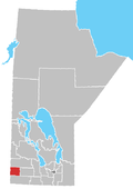
Location of Cromer in Manitoba | |
| Coordinates: 49°43′53″N 101°14′6″W / 49.73139°N 101.23500°W / 49.73139; -101.23500 | |
| Country | |
| Province | |
| Region | Westman Region |
| Census Division | No. 6 |
| Government | |
| • Governing Body | Rural Municipality of Pipestone Council |
| • MP | Larry Maguire |
| • MLA | Greg Nesbitt |
| Time zone | UTC−6 (CST) |
| • Summer (DST) | UTC−5 (CDT) |
| Postal Code | R0M 0J0 |
| Area code | 204 |
| NTS Map | 062F11 |
| GNBC Code | GAFUR |
Cromer, Manitoba is a village located in the Rural Municipality of Pipestone, in south-western Manitoba, Canada in a region called Westman.
In 1884 the Post Office was opened at LSD 26-8-28W and was known as Elm Valley.[2] The name was changed to Cromer when the Canadian Northern Railway came through in 1907.
The community is situated alongside Pipestone Creek in the Pipestone Valley. The valley was formed almost 20,000 years ago during the melting of the last glaciation. The melting waters formed the Pipestone Spillway, which is the valley seen today. The village sits at the intersections of roads 256 and 255 and consists of several businesses, residences, and churches. There is also an ice rink and a 9-hole golf course.[3]
Enbridge Line 2B starts just north of the village at the Tundra Oil & Gas plant.

- Cromer United Church

The Cromer United Church, built in 1911, is designated "Manitoba Municipal Heritage Site No. 89"[4] and part of the Canadian Register of Historic Places.[5] It was originally called Cromer Methodist Church and was built for the Methodist congregation and its architecture is a modest Gothic Revival-style wooden church. As a heritage site, it was recognised on 10 December 1992 and was listed in the Canadian Register on 17 February 2006.
Notable residents
- Mary Carter, judge [6]
See also
References
- ^ "Population and dwelling counts, for Canada and census subdivisions (municipalities), 2006 and 2001 censuses - 100% data". Statistics Canada, 2006 Census of Population. 5 November 2008. Retrieved 30 January 2009.
- ^ 1981 Trails Along the Pipestone - a history book of the Municipality of Pipestone.
- ^ "Cromer Golf Course in Cromer, Manitoba, Canada".
- ^ "HistoricPlaces.ca - HistoricPlaces.ca".
- ^ "Manitoba Municipal Heritage Site No. 89 - Cromer United Church | Municipal Heritage Sites | Historic Resources Branch".
- ^ Beth Bilson, Profile of Mary Carter Archived 2017-07-10 at the Wayback Machine. Encyclopedia of Saskatchewan. Retrieved 2016-11-29.
External links
- Geographic Names of Manitoba (pg. 57) - the Millennium Bureau of Canada
 Media related to Cromer, Manitoba at Wikimedia Commons
 Canada portal

