Avenue B and C, Arizona
Avenue B and C, Arizona | |
|---|---|
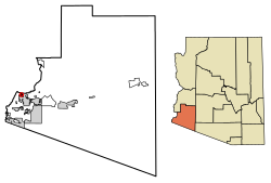
 Location of Avenue B and C in Yuma County, Arizona. | |
| Country | United States |
| State | Arizona |
| County | Yuma |
| Area [1] | |
| • Total | 0.74 sq mi (1.92 km2) |
| • Land | 0.74 sq mi (1.91 km2) |
| • Water | 0.01 sq mi (0.02 km2) |
| Population (2020) | |
| • Total | 4,101 |
| • Density | 5,572.01/sq mi (2,152.53/km2) |
| Time zone | UTC-7 (MST (no DST)) |
| ZIP code | 85364[2] |
| Area code | 928 |
| FIPS code | 04-04710 |
Avenue B and C or B&C Colonia is a census-designated place (CDP)[3] and colonia[4] in Yuma County, Arizona, United States.[3] The population was 4,176 at the 2010 census. Areas that are part of Avenue B and C were first subdivided in the 1920s and 1930s.[5] The colonia received a sewer system in 2011.[6] It is the fifth most populous community in Yuma County and second most populous CDP (behind Fortuna Foothills).[7]
Demographics
| Census | Pop. | Note | %± |
|---|---|---|---|
| 2010 | 4,176 | — | |
| 2020 | 4,101 | −1.8% | |
| U.S. Decennial Census[8] | |||
Avenue B and C first appeared on the 2010 U.S. Census as a census-designated place (CDP).[7]
At the 2020 census, Avenue B and C had a population of 4,176. The racial and ethnic makeup of the population was 22.0% non-Hispanic white, 0.9% black or African American, 2.5% Native American, 0.3% Asian, 0.3% Pacific Islander, 0.1% non-Hispanic of some other race, 3.2% from two or more races and 74.7% Hispanic or Latino.[9]
Notes
- ^ "2020 U.S. Gazetteer Files". United States Census Bureau. Retrieved October 29, 2021.
- ^ "Avenue B and C ZIP Code". zipdatamaps.com. 2023. Retrieved January 12, 2023.
- ^ a b U.S. Geological Survey Geographic Names Information System: Avenue B and C, Arizona
- ^ "Finding of No Significant Impact" (PDF). United States Environmental Protection Agency. Archived from the original (PDF) on June 28, 2011. Retrieved March 15, 2011.
- ^ "Geocortex Viewer for HTML5".
- ^ Arizona Colonia Neighbors Get a New, Safe, Waste Disposal System
- ^ a b U.S. Census Bureau (October 2012). "Arizona: 2010 - Summary Population and Housing Characteristics" (PDF). U.S. Government Printing Office.
- ^ "Census of Population and Housing". Census.gov. Retrieved June 4, 2016.
- ^ 2010 Census report for Avenue B and C
32°43′09″N 114°39′36″W / 32.71917°N 114.66000°W / 32.71917; -114.66000
