Angara
| Angara | |
|---|---|
 | |
 | |
| Location | |
| Country | Russia |
| Regions | Irkutsk Oblast, Krasnoyarsk Krai |
| Physical characteristics | |
| Source | Lake Baikal |
| • location | Baykal, Irkutsk Oblast |
| • coordinates | 51°52′01″N 104°49′05″E / 51.867°N 104.818°E / 51.867; 104.818 |
| • elevation | 389 m (1,276 ft) |
| Mouth | Yenisey |
• location | Lesosibirsk, Krasnoyarsk Krai |
• coordinates | 58°06′07″N 92°59′28″E / 58.102°N 92.991°E / 58.102; 92.991 |
• elevation | 75 m (246 ft) |
| Length | 1,849 km (1,149 mi)[1] to 1,779 km (1,105 mi)[2] |
| Basin size | 1,039,000 km2 (401,000 sq mi)[1] to 1,056,000 km2 (408,000 sq mi)[2] |
| Discharge | |
| • location | Confluence of the Yenisey (near mouth) |
| • average | 4,530 m3/s (160,000 cu ft/s) to 4,980 m3/s (176,000 cu ft/s)[2] |
| Basin features | |
| Progression | Yenisey→ Kara Sea |
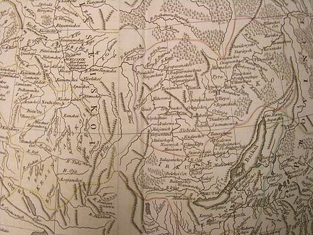
The Angara (Russian: Ангара́, [ənɡɐˈra]; Buryat: Ангар, Angar, lit. "Cleft"[citation needed]) is a major river in Siberia, which traces a course through Russia's Irkutsk Oblast and Krasnoyarsk Krai. It drains out of Lake Baikal and is the headwater tributary of the Yenisey.[3] It is 1,849 kilometres (1,149 mi) long, and has a drainage basin of 1,039,000 square kilometres (401,000 sq mi).[1] It was formerly known as the Lower or Nizhnyaya Angara (distinguishing it from the Upper Angara).[4] Below its junction with the Ilim, it was formerly known as the Upper Tunguska (Russian: Верхняя Тунгуска, Verhnyaya Tunguska, distinguishing it from the Lower Tunguska)[5][6] and, with the names reversed, as the Lower Tunguska.[7]
Course
Leaving Lake Baikal near the settlement of Listvyanka, the Angara flows north past the Irkutsk Oblast cities of Irkutsk, Angarsk, Bratsk, and Ust-Ilimsk. It then crosses the Angara Range and turns west, entering Krasnoyarsk Krai, and joining the Yenisey near Strelka, 40 kilometres (25 mi) south-east of Lesosibirsk.
Dams and reservoirs

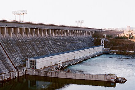
Four dams of major hydroelectric plants - constructed since the 1950s - exploit the waters of the Angara:
- Irkutsk Dam, forming the Irkutsk Reservoir, which floods the valley of the river from its source to Irkutsk, and slightly raises the water level in Lake Baikal
- Bratsk Dam, forming the Bratsk Reservoir
- Ust-Ilimsk Dam, at Ust-Ilimsk, forming the Ust-Ilimsk Reservoir
- Boguchany Dam, at Kodinsk
The reservoirs of these dams flooded a number of villages along the Angara and its tributaries (including the historic fort of Ilimsk on the Ilim), as well as numerous agricultural areas in the river valley. Due to its effects on the way of life of the rural residents of the Angara valley, dam construction was criticized by a number of Soviet intellectuals, in particular by the Irkutsk writer Valentin Rasputin - both in his novel Farewell to Matyora (1976) and in his non-fiction book Siberia, Siberia (1991).


The Angara is navigable by modern watercraft on several isolated sections:[8][9][10]
- from Lake Baikal to Irkutsk
- from Irkutsk to Bratsk
- on the Ust-Ilimsk Reservoir
- from the Boguchany Dam (Kodinsk) to the river's fall into the Yenisey.
The section between the Ust-Ilimsk Dam and the Boguchany Dam has not been navigable due to rapids. However, with the completion of the Boguchany Dam, and filling of its reservoir, at least part of this section of the river will become navigable as well. Nonetheless, this will not enable through navigation from Lake Baikal to the Yenisey, as none of the existing three dams has been provided with a ship lock or a boat lift, nor will the Boguchany Dam have one.

Despite the absence of a continuous navigable waterway, the Angara and its tributary the Ilim were of considerable importance for Russian colonization of Siberia since ca. 1630, when they (and the necessary portages) formed important water routes connecting the Yenisey with Lake Baikal and the Lena. The river lost its transportation significance after the construction of an overland route between Krasnoyarsk and Irkutsk and, later, the Trans-Siberian Railway.
Tributaries
The largest tributaries of the Angara are, from source to mouth:[1][11]
See also
References
Citations
- ^ a b c d "Река Ангара in the State Water Register of Russia". verum.wiki (in Russian).
- ^ a b c "Yenisey River".
- ^ "Angara River". Encyclopædia Britannica Online. Retrieved 2006-10-26.
- ^ EB (1878).
- ^ ВЕРХНЯЯ ТУНГУСКА (Verkhnyaya Tunguska, in the dictionary of Russia's place names).
- ^ Tunguska, in Columbia Electronic Encyclopedia
- ^ See, e.g., the 1773 Kitchen map above.
- ^ "Angara River, southeast-central Russia". Archived from the original on 2017-06-10. Retrieved 2006-10-26.
- ^ Енисейское пароходство: Ангара – судоходство и грузоперевозки (Yenisey Shipping Company: Angara — navigation and cargo shipping) (in Russian)
- ^ Особенности движения и стоянки судов по внутренним водным путям Восточно-Сибирского бассейна Archived March 13, 2008, at the Wayback Machine (Special navigation rules for the internal waterways of the Eastern Siberia Basin) (in Russian)
- ^ Ангара, Great Soviet Encyclopedia
Bibliography
- , 'Encyclopædia Britannica, 9th ed., Vol. II, New York: Charles Scribner's Sons, 1878, p. 26.
External links
- Angara River, southeast-central Russia Archived 2017-06-10 at the Wayback Machine
- Angara River
- Angara River photo
- Map of region showing mouth of Angara River
- Map book of region showing mouth of Angara River Archived 2016-01-09 at the Wayback Machine
- Photo of river and dam